
Size of this PNG preview of this SVG file:
800 × 188 pixels. Other resolutions:
320 × 75 pixels |
640 × 150 pixels |
1,024 × 240 pixels |
1,280 × 300 pixels |
2,560 × 600 pixels |
3,200 × 750 pixels.
Original file (SVG file, nominally 3,200 × 750 pixels, file size: 147 KB)
| This is a file from the
Wikimedia Commons. Information from its
description page there is shown below. Commons is a freely licensed media file repository. You can help. |
Summary
| Description |
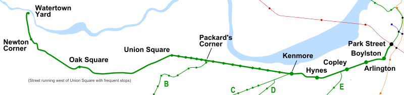
English: Geographic map of the former MBTA Green Line "A" Branch (Watertown Line), made from OpenStreetMap data. Routes are as they were in 1969; the Causeway Street (Green Line) and Washington Street and Charlestown (Orange Line) elevateds are shown. |
| Date | |
| Source | Own work |
| Author | Pi.1415926535 |
Licensing
I, the copyright holder of this work, hereby publish it under the following licenses:
This file is licensed under the
Creative Commons
Attribution-Share Alike 3.0 Unported license.
- You are free:
- to share – to copy, distribute and transmit the work
- to remix – to adapt the work
- Under the following conditions:
- attribution – You must give appropriate credit, provide a link to the license, and indicate if changes were made. You may do so in any reasonable manner, but not in any way that suggests the licensor endorses you or your use.
- share alike – If you remix, transform, or build upon the material, you must distribute your contributions under the same or compatible license as the original.

|
Permission is granted to copy, distribute and/or modify this document under the terms of the GNU Free Documentation License, Version 1.2 or any later version published by the Free Software Foundation; with no Invariant Sections, no Front-Cover Texts, and no Back-Cover Texts. A copy of the license is included in the section entitled GNU Free Documentation License. |
You may select the license of your choice.
File history
Click on a date/time to view the file as it appeared at that time.
| Date/Time | Thumbnail | Dimensions | User | Comment | |
|---|---|---|---|---|---|
| current | 06:08, 7 June 2020 |
| 3,200 × 750 (147 KB) | Pi.1415926535 | correct geography; add stops that existed at the time; simplify text; etc |
| 04:33, 15 September 2011 |
| 3,200 × 750 (266 KB) | Pi.1415926535 | {{Information |Description ={{en|1=Geographic map of the former MBTA Green Line "A" Branch (Watertown Line), made from OpenStreetMap data}} |Source ={{own}} |Author = Pi.1415926535 |Date =15 September 201 |
File usage
The following pages on the English Wikipedia use this file (pages on other projects are not listed):
Global file usage
The following other wikis use this file:
- Usage on de.wikipedia.org
Metadata
Size of this PNG preview of this SVG file:
800 × 188 pixels. Other resolutions:
320 × 75 pixels |
640 × 150 pixels |
1,024 × 240 pixels |
1,280 × 300 pixels |
2,560 × 600 pixels |
3,200 × 750 pixels.
Original file (SVG file, nominally 3,200 × 750 pixels, file size: 147 KB)
| This is a file from the
Wikimedia Commons. Information from its
description page there is shown below. Commons is a freely licensed media file repository. You can help. |
Summary
| Description |
English: Geographic map of the former MBTA Green Line "A" Branch (Watertown Line), made from OpenStreetMap data. Routes are as they were in 1969; the Causeway Street (Green Line) and Washington Street and Charlestown (Orange Line) elevateds are shown. |
| Date | |
| Source | Own work |
| Author | Pi.1415926535 |
Licensing
I, the copyright holder of this work, hereby publish it under the following licenses:
This file is licensed under the
Creative Commons
Attribution-Share Alike 3.0 Unported license.
- You are free:
- to share – to copy, distribute and transmit the work
- to remix – to adapt the work
- Under the following conditions:
- attribution – You must give appropriate credit, provide a link to the license, and indicate if changes were made. You may do so in any reasonable manner, but not in any way that suggests the licensor endorses you or your use.
- share alike – If you remix, transform, or build upon the material, you must distribute your contributions under the same or compatible license as the original.
|
|
Permission is granted to copy, distribute and/or modify this document under the terms of the GNU Free Documentation License, Version 1.2 or any later version published by the Free Software Foundation; with no Invariant Sections, no Front-Cover Texts, and no Back-Cover Texts. A copy of the license is included in the section entitled GNU Free Documentation License. |
You may select the license of your choice.
File history
Click on a date/time to view the file as it appeared at that time.
| Date/Time | Thumbnail | Dimensions | User | Comment | |
|---|---|---|---|---|---|
| current | 06:08, 7 June 2020 |
| 3,200 × 750 (147 KB) | Pi.1415926535 | correct geography; add stops that existed at the time; simplify text; etc |
| 04:33, 15 September 2011 |
| 3,200 × 750 (266 KB) | Pi.1415926535 | {{Information |Description ={{en|1=Geographic map of the former MBTA Green Line "A" Branch (Watertown Line), made from OpenStreetMap data}} |Source ={{own}} |Author = Pi.1415926535 |Date =15 September 201 |
File usage
The following pages on the English Wikipedia use this file (pages on other projects are not listed):
Global file usage
The following other wikis use this file:
- Usage on de.wikipedia.org