Photos • Location


Size of this preview:
450 × 600 pixels. Other resolutions:
180 × 240 pixels |
360 × 480 pixels |
576 × 768 pixels |
768 × 1,024 pixels |
2,304 × 3,072 pixels.
Original file (2,304 × 3,072 pixels, file size: 3.6 MB, MIME type: image/jpeg)
| This is a file from the
Wikimedia Commons. Information from its
description page there is shown below. Commons is a freely licensed media file repository. You can help. |
Summary
| Description |
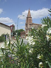
Français : Grépiac (
Haute-Garonne, France) - Église Saint-Martin. |
| Date | 28 July 2009 (according to author) |
| Source | Self-photographed |
| Author | MDG |
| Object location |
| View this and other nearby images on: OpenStreetMap |
|
|---|
Licensing
| I, the copyright holder of this work, release this work into the
public domain. This applies worldwide. In some countries this may not be legally possible; if so: I grant anyone the right to use this work for any purpose, without any conditions, unless such conditions are required by law. |
File history
Click on a date/time to view the file as it appeared at that time.
| Date/Time | Thumbnail | Dimensions | User | Comment | |
|---|---|---|---|---|---|
| current | 05:31, 28 July 2009 |
| 2,304 × 3,072 (3.6 MB) | MDG~commonswiki | {{Information |Description={{fr|1=coeur}} {{fr|1=du village}} |Source=travail personnel (own work) |Author= MDG |Date=2009-07-28 |Permission=mairiedg |other_versions= }} |
File usage
The following pages on the English Wikipedia use this file (pages on other projects are not listed):
Global file usage
The following other wikis use this file:
- Usage on an.wikipedia.org
- Usage on ca.wikipedia.org
- Usage on ceb.wikipedia.org
- Usage on ce.wikipedia.org
- Usage on de.wikipedia.org
- Usage on es.wikipedia.org
- Usage on eu.wikipedia.org
- Usage on fr.wikipedia.org
- Usage on hu.wikipedia.org
- Usage on it.wikipedia.org
- Usage on ku.wikipedia.org
- Usage on nl.wikipedia.org
- Usage on oc.wikipedia.org
- Usage on pl.wikipedia.org
- Usage on pt.wikipedia.org
- Usage on ro.wikipedia.org
- Usage on ru.wikipedia.org
- Usage on sk.wikipedia.org
- Usage on sq.wikipedia.org
- Usage on sv.wikipedia.org
- Usage on tt.wikipedia.org
- Usage on uk.wikipedia.org
- Usage on uz.wikipedia.org
- Usage on vec.wikipedia.org
- Usage on www.wikidata.org
- Usage on zh-min-nan.wikipedia.org
- Usage on zh-yue.wikipedia.org
- Usage on zh.wikipedia.org
Metadata
Size of this preview:
450 × 600 pixels. Other resolutions:
180 × 240 pixels |
360 × 480 pixels |
576 × 768 pixels |
768 × 1,024 pixels |
2,304 × 3,072 pixels.
Original file (2,304 × 3,072 pixels, file size: 3.6 MB, MIME type: image/jpeg)
| This is a file from the
Wikimedia Commons. Information from its
description page there is shown below. Commons is a freely licensed media file repository. You can help. |
Summary
| Description |
Français : Grépiac (
Haute-Garonne, France) - Église Saint-Martin. |
| Date | 28 July 2009 (according to author) |
| Source | Self-photographed |
| Author | MDG |
| Object location |
| View this and other nearby images on: OpenStreetMap |
|
|---|
Licensing
| I, the copyright holder of this work, release this work into the
public domain. This applies worldwide. In some countries this may not be legally possible; if so: I grant anyone the right to use this work for any purpose, without any conditions, unless such conditions are required by law. |
File history
Click on a date/time to view the file as it appeared at that time.
| Date/Time | Thumbnail | Dimensions | User | Comment | |
|---|---|---|---|---|---|
| current | 05:31, 28 July 2009 |
| 2,304 × 3,072 (3.6 MB) | MDG~commonswiki | {{Information |Description={{fr|1=coeur}} {{fr|1=du village}} |Source=travail personnel (own work) |Author= MDG |Date=2009-07-28 |Permission=mairiedg |other_versions= }} |
File usage
The following pages on the English Wikipedia use this file (pages on other projects are not listed):
Global file usage
The following other wikis use this file:
- Usage on an.wikipedia.org
- Usage on ca.wikipedia.org
- Usage on ceb.wikipedia.org
- Usage on ce.wikipedia.org
- Usage on de.wikipedia.org
- Usage on es.wikipedia.org
- Usage on eu.wikipedia.org
- Usage on fr.wikipedia.org
- Usage on hu.wikipedia.org
- Usage on it.wikipedia.org
- Usage on ku.wikipedia.org
- Usage on nl.wikipedia.org
- Usage on oc.wikipedia.org
- Usage on pl.wikipedia.org
- Usage on pt.wikipedia.org
- Usage on ro.wikipedia.org
- Usage on ru.wikipedia.org
- Usage on sk.wikipedia.org
- Usage on sq.wikipedia.org
- Usage on sv.wikipedia.org
- Usage on tt.wikipedia.org
- Usage on uk.wikipedia.org
- Usage on uz.wikipedia.org
- Usage on vec.wikipedia.org
- Usage on www.wikidata.org
- Usage on zh-min-nan.wikipedia.org
- Usage on zh-yue.wikipedia.org
- Usage on zh.wikipedia.org