No higher resolution available.
Gilarivermap.png (499 × 500 pixels, file size: 382 KB, MIME type: image/png)
| This is a file from the
Wikimedia Commons. Information from its
description page there is shown below. Commons is a freely licensed media file repository. You can help. |
| Description |
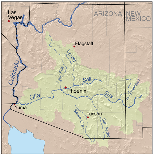
English: Map of the
Gila River watershed-drainage basin — located in
New Mexico and
Arizona.
|
| Date | |
| Source | Self-made, based on USGS data. |
| Author | Kmusser |
I, the copyright holder of this work, hereby publish it under the following license:
This file is licensed under the
Creative Commons
Attribution-Share Alike 2.5 Generic license.
- You are free:
- to share – to copy, distribute and transmit the work
- to remix – to adapt the work
- Under the following conditions:
- attribution – You must give appropriate credit, provide a link to the license, and indicate if changes were made. You may do so in any reasonable manner, but not in any way that suggests the licensor endorses you or your use.
- share alike – If you remix, transform, or build upon the material, you must distribute your contributions under the same or compatible license as the original.
File history
Click on a date/time to view the file as it appeared at that time.
| Date/Time | Thumbnail | Dimensions | User | Comment | |
|---|---|---|---|---|---|
| current | 18:48, 13 September 2007 |
| 499 × 500 (382 KB) | Kmusser | {{Information |Description=Map of the Gila River watershed. |Source=Self-made, based on USGS data. |Date=September 13, 2007 |Author= Kmusser }} {{self|cc-by-sa-2.5}} [[Category:Maps of rivers of the Unite |
File usage
The following pages on the English Wikipedia use this file (pages on other projects are not listed):
- Agua Fria River
- Centennial Wash (Maricopa County)
- East Verde River
- Gila River
- Juan Bautista de Anza National Historic Trail
- List of longest rivers of the United States (by main stem)
- List of tributaries of the Gila River
- Salt River Valley
- San Francisco River (Gila River tributary)
- San Pedro River (Arizona)
- Verde River
- User:Kmusser/Images
- Category:Gila River
- Category:Regions of Arizona
Global file usage
The following other wikis use this file:
- Usage on af.wikipedia.org
- Usage on ar.wikipedia.org
- Usage on arz.wikipedia.org
- Usage on bg.wikipedia.org
- Usage on ca.wikipedia.org
- Usage on ceb.wikipedia.org
- Usage on cs.wikipedia.org
- Usage on cy.wikipedia.org
- Usage on de.wikipedia.org
- Usage on es.wikipedia.org
- Usage on et.wikipedia.org
- Usage on fa.wikipedia.org
- Usage on fi.wikipedia.org
- Usage on fr.wikipedia.org
- Usage on he.wikipedia.org
- Usage on hy.wikipedia.org
- Usage on id.wikipedia.org
- Usage on it.wikipedia.org
- Usage on ja.wikipedia.org
- Usage on lt.wikipedia.org
- Usage on mr.wikipedia.org
- Usage on nl.wikipedia.org
View more global usage of this file.
No higher resolution available.
Gilarivermap.png (499 × 500 pixels, file size: 382 KB, MIME type: image/png)
| This is a file from the
Wikimedia Commons. Information from its
description page there is shown below. Commons is a freely licensed media file repository. You can help. |
| Description |
English: Map of the
Gila River watershed-drainage basin — located in
New Mexico and
Arizona.
|
| Date | |
| Source | Self-made, based on USGS data. |
| Author | Kmusser |
I, the copyright holder of this work, hereby publish it under the following license:
This file is licensed under the
Creative Commons
Attribution-Share Alike 2.5 Generic license.
- You are free:
- to share – to copy, distribute and transmit the work
- to remix – to adapt the work
- Under the following conditions:
- attribution – You must give appropriate credit, provide a link to the license, and indicate if changes were made. You may do so in any reasonable manner, but not in any way that suggests the licensor endorses you or your use.
- share alike – If you remix, transform, or build upon the material, you must distribute your contributions under the same or compatible license as the original.
File history
Click on a date/time to view the file as it appeared at that time.
| Date/Time | Thumbnail | Dimensions | User | Comment | |
|---|---|---|---|---|---|
| current | 18:48, 13 September 2007 |
| 499 × 500 (382 KB) | Kmusser | {{Information |Description=Map of the Gila River watershed. |Source=Self-made, based on USGS data. |Date=September 13, 2007 |Author= Kmusser }} {{self|cc-by-sa-2.5}} [[Category:Maps of rivers of the Unite |
File usage
The following pages on the English Wikipedia use this file (pages on other projects are not listed):
- Agua Fria River
- Centennial Wash (Maricopa County)
- East Verde River
- Gila River
- Juan Bautista de Anza National Historic Trail
- List of longest rivers of the United States (by main stem)
- List of tributaries of the Gila River
- Salt River Valley
- San Francisco River (Gila River tributary)
- San Pedro River (Arizona)
- Verde River
- User:Kmusser/Images
- Category:Gila River
- Category:Regions of Arizona
Global file usage
The following other wikis use this file:
- Usage on af.wikipedia.org
- Usage on ar.wikipedia.org
- Usage on arz.wikipedia.org
- Usage on bg.wikipedia.org
- Usage on ca.wikipedia.org
- Usage on ceb.wikipedia.org
- Usage on cs.wikipedia.org
- Usage on cy.wikipedia.org
- Usage on de.wikipedia.org
- Usage on es.wikipedia.org
- Usage on et.wikipedia.org
- Usage on fa.wikipedia.org
- Usage on fi.wikipedia.org
- Usage on fr.wikipedia.org
- Usage on he.wikipedia.org
- Usage on hy.wikipedia.org
- Usage on id.wikipedia.org
- Usage on it.wikipedia.org
- Usage on ja.wikipedia.org
- Usage on lt.wikipedia.org
- Usage on mr.wikipedia.org
- Usage on nl.wikipedia.org
View more global usage of this file.