No higher resolution available.
Ghaznavid_Empire_975_-_1187_(AD).PNG (620 × 428 pixels, file size: 20 KB, MIME type: image/png)
| This is a file from the
Wikimedia Commons. Information from its
description page there is shown below. Commons is a freely licensed media file repository. You can help. |
.PNG)
Summary
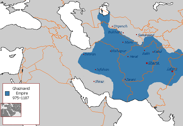
| Description |
Polski: Państwo
Ghaznawidów
English:
Ghaznavid Empire |
| Date | |
| Source | Own work |
| Author | Arab League |
| Other versions | Arabic |
-ar.PNG)
Licensing
| This work has been released into the
public domain by its author,
Arab League at
English Wikipedia. This applies worldwide. In some countries this may not be legally possible; if so: Arab League grants anyone the right to use this work for any purpose, without any conditions, unless such conditions are required by law. |
File history
Click on a date/time to view the file as it appeared at that time.
.PNG&dir=prev)
.PNG&offset=20130607145450)
.PNG&offset=&limit=20)
.PNG&offset=&limit=50)
.PNG&offset=&limit=100)
.PNG&offset=&limit=250)
.PNG&offset=&limit=500)
| Date/Time | Thumbnail | Dimensions | User | Comment | |
|---|---|---|---|---|---|
| current | 04:54, 7 July 2015 |
| 620 × 428 (20 KB) | HistoryofIran | Of course Iranica doesn't, it states which areas they ruled at their extent, stop making reverts without discussing.. |
| 01:05, 4 July 2015 |
 | 619 × 428 (21 KB) | Persia10101 | More accurate map after some research | |
| 01:05, 4 July 2015 |
 | 619 × 428 (21 KB) | Persia10101 | More accurate map after some research | |
| 00:58, 4 July 2015 |
 | 620 × 428 (26 KB) | Persia10101 | Iranica doesnt show a map. reverting to the more commonly agreed map | |
| 00:57, 4 July 2015 |
 | 620 × 428 (26 KB) | Persia10101 | Reverted to version as of 08:05, 14 August 2011 | |
| 12:08, 9 May 2014 |
 | 620 × 428 (20 KB) | HistoryofIran | Further fixed the map, i will be adding vassals later. | |
| 23:47, 28 January 2014 |
 | 620 × 428 (20 KB) | HistoryofIran | Fars and Kerman remained under Buyid rule until the Seljuqs came. | |
| 15:01, 7 June 2013 |
 | 620 × 428 (20 KB) | HistoryofIran | Fixed the map, according to Iranica the map was like this at it's greatest extent. | |
| 14:58, 7 June 2013 |
 | 620 × 428 (20 KB) | HistoryofIran | Fixed the map, according to Iranica the map was like this at it's greatest extent. | |
| 14:54, 7 June 2013 |
 | 620 × 428 (20 KB) | HistoryofIran | Fixed the map, according to Iranica the map was like this at it's greatest extent. |
File usage
The following pages on the English Wikipedia use this file (pages on other projects are not listed):
- Greater Iran
- History of Afghanistan
- Jasrota
- Muslim conquest of Khorasan
- Muslim conquests of Afghanistan
- Nurpur kingdom
- Shia Islam in the Indian subcontinent
- Turkic peoples
- User:Arab Hafez/Map
- User:Kansas Bear/Ghaznavids
- User:Kansas Bear/Saffarid dynasty
- User:Kypioys sx/sandbox
- User:Northamerica1000/Portals of the world
- User:Ottava Rima/Persian Empire
- User:Sobreira/Religion
- Portal:Afghanistan
Global file usage
The following other wikis use this file:
- Usage on arz.wikipedia.org
- Usage on ast.wikipedia.org
- Usage on av.wikipedia.org
- Usage on azb.wikipedia.org
- Usage on az.wikipedia.org
- Usage on ba.wikipedia.org
- Usage on be.wikipedia.org
- Usage on bg.wikipedia.org
- Usage on bn.wikipedia.org
- Usage on ca.wikipedia.org
- Usage on ceb.wikipedia.org
- Usage on ckb.wikipedia.org
- Usage on da.wikipedia.org
- Usage on de.wikipedia.org
- Usage on el.wikipedia.org
- Usage on eo.wikipedia.org
- Usage on es.wikipedia.org
- Usage on et.wikipedia.org
- Usage on eu.wikipedia.org
- Usage on fa.wikipedia.org
View more global usage of this file.
.PNG)
Metadata
.PNG)
No higher resolution available.
Ghaznavid_Empire_975_-_1187_(AD).PNG (620 × 428 pixels, file size: 20 KB, MIME type: image/png)
| This is a file from the
Wikimedia Commons. Information from its
description page there is shown below. Commons is a freely licensed media file repository. You can help. |
Summary
| Description |
Polski: Państwo
Ghaznawidów
English:
Ghaznavid Empire |
| Date | |
| Source | Own work |
| Author | Arab League |
| Other versions | Arabic |
Licensing
| This work has been released into the
public domain by its author,
Arab League at
English Wikipedia. This applies worldwide. In some countries this may not be legally possible; if so: Arab League grants anyone the right to use this work for any purpose, without any conditions, unless such conditions are required by law. |
File history
Click on a date/time to view the file as it appeared at that time.
| Date/Time | Thumbnail | Dimensions | User | Comment | |
|---|---|---|---|---|---|
| current | 04:54, 7 July 2015 |
| 620 × 428 (20 KB) | HistoryofIran | Of course Iranica doesn't, it states which areas they ruled at their extent, stop making reverts without discussing.. |
| 01:05, 4 July 2015 |
| 619 × 428 (21 KB) | Persia10101 | More accurate map after some research | |
| 01:05, 4 July 2015 |
| 619 × 428 (21 KB) | Persia10101 | More accurate map after some research | |
| 00:58, 4 July 2015 |
| 620 × 428 (26 KB) | Persia10101 | Iranica doesnt show a map. reverting to the more commonly agreed map | |
| 00:57, 4 July 2015 |
| 620 × 428 (26 KB) | Persia10101 | Reverted to version as of 08:05, 14 August 2011 | |
| 12:08, 9 May 2014 |
| 620 × 428 (20 KB) | HistoryofIran | Further fixed the map, i will be adding vassals later. | |
| 23:47, 28 January 2014 |
| 620 × 428 (20 KB) | HistoryofIran | Fars and Kerman remained under Buyid rule until the Seljuqs came. | |
| 15:01, 7 June 2013 |
| 620 × 428 (20 KB) | HistoryofIran | Fixed the map, according to Iranica the map was like this at it's greatest extent. | |
| 14:58, 7 June 2013 |
| 620 × 428 (20 KB) | HistoryofIran | Fixed the map, according to Iranica the map was like this at it's greatest extent. | |
| 14:54, 7 June 2013 |
| 620 × 428 (20 KB) | HistoryofIran | Fixed the map, according to Iranica the map was like this at it's greatest extent. |
File usage
The following pages on the English Wikipedia use this file (pages on other projects are not listed):
- Greater Iran
- History of Afghanistan
- Jasrota
- Muslim conquest of Khorasan
- Muslim conquests of Afghanistan
- Nurpur kingdom
- Shia Islam in the Indian subcontinent
- Turkic peoples
- User:Arab Hafez/Map
- User:Kansas Bear/Ghaznavids
- User:Kansas Bear/Saffarid dynasty
- User:Kypioys sx/sandbox
- User:Northamerica1000/Portals of the world
- User:Ottava Rima/Persian Empire
- User:Sobreira/Religion
- Portal:Afghanistan
Global file usage
The following other wikis use this file:
- Usage on arz.wikipedia.org
- Usage on ast.wikipedia.org
- Usage on av.wikipedia.org
- Usage on azb.wikipedia.org
- Usage on az.wikipedia.org
- Usage on ba.wikipedia.org
- Usage on be.wikipedia.org
- Usage on bg.wikipedia.org
- Usage on bn.wikipedia.org
- Usage on ca.wikipedia.org
- Usage on ceb.wikipedia.org
- Usage on ckb.wikipedia.org
- Usage on da.wikipedia.org
- Usage on de.wikipedia.org
- Usage on el.wikipedia.org
- Usage on eo.wikipedia.org
- Usage on es.wikipedia.org
- Usage on et.wikipedia.org
- Usage on eu.wikipedia.org
- Usage on fa.wikipedia.org
View more global usage of this file.