
Size of this preview:
421 × 599 pixels. Other resolutions:
169 × 240 pixels |
592 × 842 pixels.
Original file (592 × 842 pixels, file size: 77 KB, MIME type: image/png)
| This is a file from the
Wikimedia Commons. Information from its
description page there is shown below. Commons is a freely licensed media file repository. You can help. |
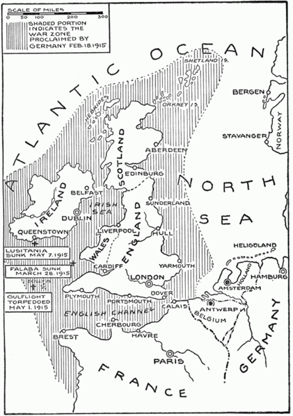
| Description | Map showing submarine warfare zone around the United Kingdom, declared by Germany on February 18 1915. | ||
| Date | |||
| Source |
"The Sory of the Great War" Volume V. Edited by Francis J Reynolds, Allen C Churchill, Francis Trevelyan Miller. Publised by John A Collier & Son Company, New York, 1919. Downloaded from Project Gutenberg at http://www.gutenberg.org/ebooks/23861 |
||
| Author | artist not identified | ||
| Permission ( Reusing this file) |
|
||
| Other versions | Derivative works of this file: German Submarine Zone February 1915 after Reynolds et al.jpg |
File history
Click on a date/time to view the file as it appeared at that time.
| Date/Time | Thumbnail | Dimensions | User | Comment | |
|---|---|---|---|---|---|
| current | 10:03, 7 February 2009 |
| 592 × 842 (77 KB) | Rcbutcher | {{Information |Description=Map showing submarine warfare zone around the United Kingdom, declared by Germany on February 18 1915. |Source="The Sory of the Great War" Volume V. Edited by Francis J Reynolds, Allen C Churchill, Francis Trevelyan Miller. Pub |
File usage
The following pages on the English Wikipedia use this file (pages on other projects are not listed):
Global file usage
The following other wikis use this file:
- Usage on ast.wikipedia.org
- Usage on ca.wikipedia.org
- Usage on de.wikipedia.org
- Usage on es.wikipedia.org
- Usage on fr.wikipedia.org
- Usage on he.wikipedia.org
- Usage on hu.wikipedia.org
- Usage on id.wikipedia.org
- Usage on ru.wikipedia.org
- Usage on uk.wikipedia.org
Size of this preview:
421 × 599 pixels. Other resolutions:
169 × 240 pixels |
592 × 842 pixels.
Original file (592 × 842 pixels, file size: 77 KB, MIME type: image/png)
| This is a file from the
Wikimedia Commons. Information from its
description page there is shown below. Commons is a freely licensed media file repository. You can help. |
| Description | Map showing submarine warfare zone around the United Kingdom, declared by Germany on February 18 1915. | ||
| Date | |||
| Source |
"The Sory of the Great War" Volume V. Edited by Francis J Reynolds, Allen C Churchill, Francis Trevelyan Miller. Publised by John A Collier & Son Company, New York, 1919. Downloaded from Project Gutenberg at http://www.gutenberg.org/ebooks/23861 |
||
| Author | artist not identified | ||
| Permission ( Reusing this file) |
|
||
| Other versions | Derivative works of this file: German Submarine Zone February 1915 after Reynolds et al.jpg |
File history
Click on a date/time to view the file as it appeared at that time.
| Date/Time | Thumbnail | Dimensions | User | Comment | |
|---|---|---|---|---|---|
| current | 10:03, 7 February 2009 |
| 592 × 842 (77 KB) | Rcbutcher | {{Information |Description=Map showing submarine warfare zone around the United Kingdom, declared by Germany on February 18 1915. |Source="The Sory of the Great War" Volume V. Edited by Francis J Reynolds, Allen C Churchill, Francis Trevelyan Miller. Pub |
File usage
The following pages on the English Wikipedia use this file (pages on other projects are not listed):
Global file usage
The following other wikis use this file:
- Usage on ast.wikipedia.org
- Usage on ca.wikipedia.org
- Usage on de.wikipedia.org
- Usage on es.wikipedia.org
- Usage on fr.wikipedia.org
- Usage on he.wikipedia.org
- Usage on hu.wikipedia.org
- Usage on id.wikipedia.org
- Usage on ru.wikipedia.org
- Usage on uk.wikipedia.org