No higher resolution available.
Ga-map.png (631 × 319 pixels, file size: 12 KB, MIME type: image/png)
| This is a file from the
Wikimedia Commons. Information from its
description page there is shown below. Commons is a freely licensed media file repository. You can help. |
Summary
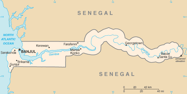
| Description |
English: Map of
Gambia |
| Date | Unknown date |
| Source | CIA World Factbook — https://www.cia.gov/library/publications/the-world-factbook/graphics/maps/ga-map.gif |
| Author | Central Intelligence Agency |
Licensing
This image is in the
public domain because it contains materials that originally came from the United States
Central Intelligence Agency's
World Factbook.
|
 |
File history
Click on a date/time to view the file as it appeared at that time.
| Date/Time | Thumbnail | Dimensions | User | Comment | |
|---|---|---|---|---|---|
| current | 00:30, 31 October 2021 |
| 631 × 319 (12 KB) | Lojwe | Cropped < 1 % horizontally, 1 % vertically using CropTool with precise mode. |
| 09:54, 7 October 2013 |
 | 634 × 323 (13 KB) | Jahoe | version as of October 2013 | |
| 06:15, 7 June 2006 |
 | 634 × 323 (11 KB) | Jed | ||
| 20:42, 3 March 2005 |
 | 637 × 323 (12 KB) | Alfio | CIA map of Gambia |
File usage
The following pages on the English Wikipedia use this file (pages on other projects are not listed):
- Alexander Grant (British Army officer)
- Gambia–Senegal border
- History of the Gambia
- List of cities in the Gambia
- List of villages in the Gambia
- The Gambia
- Wildlife of the Gambia
- User:Annatto
- User:Anonymous101/Userboxes
- User:Atamari
- User:Catjacket
- Wikipedia:Userboxes/Location/Gambia
- Wikipedia:Userboxes/WikiProjects/Regional/04
- Wikipedia:Userboxes/WikiProjects/alphabetical/12
- Wikipedia:WikiProject Gambia/Participants
- Template:User WikiProject Gambia
- Category:Populated places in the Gambia
- Category:WikiProject Gambia participants
- Module:Location map/data/Gambia
- Module:Location map/data/Gambia/doc
Global file usage
The following other wikis use this file:
- Usage on als.wikipedia.org
- Usage on ar.wikipedia.org
- Usage on ast.wikipedia.org
- Usage on azb.wikipedia.org
- Usage on be-tarask.wikipedia.org
- Usage on bg.wikipedia.org
- Usage on bn.wikipedia.org
- Usage on bs.wikipedia.org
- Usage on ca.wikipedia.org
- Usage on da.wikipedia.org
- Usage on de.wikipedia.org
- Usage on el.wikipedia.org
- Usage on en.wikinews.org
- Usage on eo.wikipedia.org
- Usage on es.wikipedia.org
- Usage on eu.wikipedia.org
- Usage on fa.wikipedia.org
- Usage on ff.wikipedia.org
- Usage on fi.wikipedia.org
- Usage on fy.wikipedia.org
- Usage on gd.wikipedia.org
- Usage on gl.wikipedia.org
- Usage on ha.wikipedia.org
- Usage on he.wikipedia.org
- Usage on hif.wikipedia.org
- Usage on hi.wikipedia.org
View more global usage of this file.
Metadata
No higher resolution available.
Ga-map.png (631 × 319 pixels, file size: 12 KB, MIME type: image/png)
| This is a file from the
Wikimedia Commons. Information from its
description page there is shown below. Commons is a freely licensed media file repository. You can help. |
Summary
| Description |
English: Map of
Gambia |
| Date | Unknown date |
| Source | CIA World Factbook — https://www.cia.gov/library/publications/the-world-factbook/graphics/maps/ga-map.gif |
| Author | Central Intelligence Agency |
Licensing
This image is in the
public domain because it contains materials that originally came from the United States
Central Intelligence Agency's
World Factbook.
|
|
File history
Click on a date/time to view the file as it appeared at that time.
| Date/Time | Thumbnail | Dimensions | User | Comment | |
|---|---|---|---|---|---|
| current | 00:30, 31 October 2021 |
| 631 × 319 (12 KB) | Lojwe | Cropped < 1 % horizontally, 1 % vertically using CropTool with precise mode. |
| 09:54, 7 October 2013 |
| 634 × 323 (13 KB) | Jahoe | version as of October 2013 | |
| 06:15, 7 June 2006 |
| 634 × 323 (11 KB) | Jed | ||
| 20:42, 3 March 2005 |
| 637 × 323 (12 KB) | Alfio | CIA map of Gambia |
File usage
The following pages on the English Wikipedia use this file (pages on other projects are not listed):
- Alexander Grant (British Army officer)
- Gambia–Senegal border
- History of the Gambia
- List of cities in the Gambia
- List of villages in the Gambia
- The Gambia
- Wildlife of the Gambia
- User:Annatto
- User:Anonymous101/Userboxes
- User:Atamari
- User:Catjacket
- Wikipedia:Userboxes/Location/Gambia
- Wikipedia:Userboxes/WikiProjects/Regional/04
- Wikipedia:Userboxes/WikiProjects/alphabetical/12
- Wikipedia:WikiProject Gambia/Participants
- Template:User WikiProject Gambia
- Category:Populated places in the Gambia
- Category:WikiProject Gambia participants
- Module:Location map/data/Gambia
- Module:Location map/data/Gambia/doc
Global file usage
The following other wikis use this file:
- Usage on als.wikipedia.org
- Usage on ar.wikipedia.org
- Usage on ast.wikipedia.org
- Usage on azb.wikipedia.org
- Usage on be-tarask.wikipedia.org
- Usage on bg.wikipedia.org
- Usage on bn.wikipedia.org
- Usage on bs.wikipedia.org
- Usage on ca.wikipedia.org
- Usage on da.wikipedia.org
- Usage on de.wikipedia.org
- Usage on el.wikipedia.org
- Usage on en.wikinews.org
- Usage on eo.wikipedia.org
- Usage on es.wikipedia.org
- Usage on eu.wikipedia.org
- Usage on fa.wikipedia.org
- Usage on ff.wikipedia.org
- Usage on fi.wikipedia.org
- Usage on fy.wikipedia.org
- Usage on gd.wikipedia.org
- Usage on gl.wikipedia.org
- Usage on ha.wikipedia.org
- Usage on he.wikipedia.org
- Usage on hif.wikipedia.org
- Usage on hi.wikipedia.org
View more global usage of this file.