Photos • Location


Size of this preview:
800 × 542 pixels. Other resolutions:
320 × 217 pixels |
640 × 434 pixels |
1,024 × 694 pixels |
1,280 × 867 pixels |
2,560 × 1,735 pixels |
3,624 × 2,456 pixels.
Original file (3,624 × 2,456 pixels, file size: 1.24 MB, MIME type: image/jpeg)
| This is a file from the
Wikimedia Commons. Information from its
description page there is shown below. Commons is a freely licensed media file repository. You can help. |
Summary
| Description |
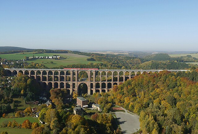
English:
Göltzsch Viaduct
Deutsch:
Göltzschtalbrücke |
| Date | |
| Source | Own work |
| Author | user:UlrichAAB |
| Camera location |
| View this and other nearby images on: OpenStreetMap |
|
|---|
| Object location |
| View this and other nearby images on: OpenStreetMap |
|
|---|
Licensing
I, the copyright holder of this work, hereby publish it under the following license:
This file is licensed under the
Creative Commons
Attribution 3.0 Unported license.
- You are free:
- to share – to copy, distribute and transmit the work
- to remix – to adapt the work
- Under the following conditions:
- attribution – You must give appropriate credit, provide a link to the license, and indicate if changes were made. You may do so in any reasonable manner, but not in any way that suggests the licensor endorses you or your use.
File history
Click on a date/time to view the file as it appeared at that time.
| Date/Time | Thumbnail | Dimensions | User | Comment | |
|---|---|---|---|---|---|
| current | 01:09, 23 October 2012 |
| 3,624 × 2,456 (1.24 MB) | UlrichAAB | reduce blue |
| 19:28, 21 October 2012 |
 | 3,624 × 2,456 (1.22 MB) | UlrichAAB |
File usage
The following pages on the English Wikipedia use this file (pages on other projects are not listed):
Global file usage
The following other wikis use this file:
- Usage on azb.wikipedia.org
- Usage on be.wikipedia.org
- Usage on cs.wikipedia.org
- Usage on de.wikipedia.org
- Vogtland
- Göltzschtalbrücke
- Johann Andreas Schubert
- Mylau
- Die Spur des Bernsteinzimmers
- Liste der Kulturdenkmale in Netzschkau
- Liste der Eisenbahnbrücken in Sachsen
- Portal:Bahn/Bildergalerie/Archiv 2015
- Liste der technischen Denkmale im Vogtlandkreis
- Liste der Kulturdenkmale in Mylau
- Benutzer:Cmuelle8/Liste der Brücken über Fließgewässer in Sachsen
- Usage on de.wikivoyage.org
- Usage on es.wikipedia.org
- Usage on fr.wikipedia.org
- Usage on hsb.wikipedia.org
- Usage on hu.wikipedia.org
- Usage on lv.wikipedia.org
- Usage on nl.wikipedia.org
- Usage on no.wikipedia.org
- Usage on ru.wikipedia.org
- Usage on uk.wikipedia.org
- Usage on vi.wikipedia.org
- Usage on www.wikidata.org
Metadata
Size of this preview:
800 × 542 pixels. Other resolutions:
320 × 217 pixels |
640 × 434 pixels |
1,024 × 694 pixels |
1,280 × 867 pixels |
2,560 × 1,735 pixels |
3,624 × 2,456 pixels.
Original file (3,624 × 2,456 pixels, file size: 1.24 MB, MIME type: image/jpeg)
| This is a file from the
Wikimedia Commons. Information from its
description page there is shown below. Commons is a freely licensed media file repository. You can help. |
Summary
| Description |
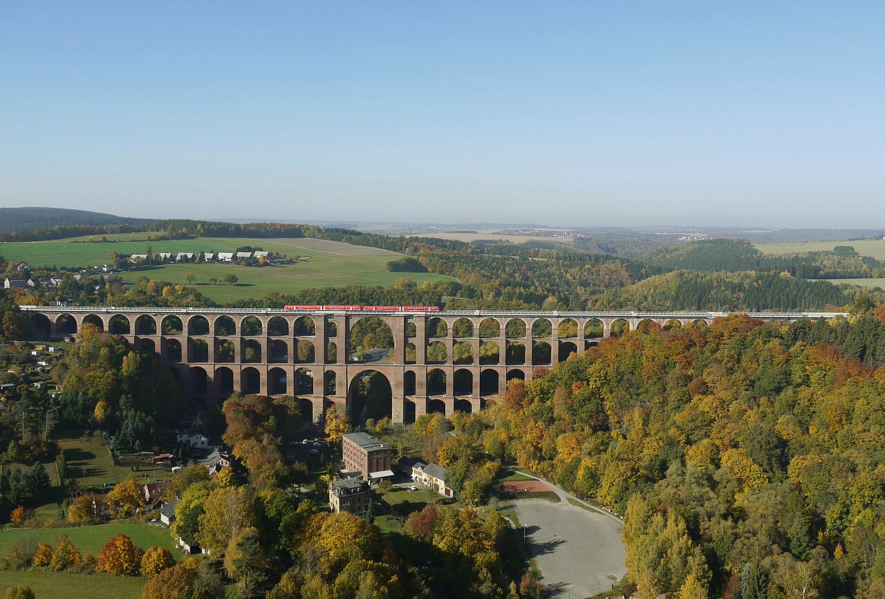
English:
Göltzsch Viaduct
Deutsch:
Göltzschtalbrücke |
| Date | |
| Source | Own work |
| Author | user:UlrichAAB |
| Camera location |
| View this and other nearby images on: OpenStreetMap |
|
|---|
| Object location |
| View this and other nearby images on: OpenStreetMap |
|
|---|
Licensing
I, the copyright holder of this work, hereby publish it under the following license:
This file is licensed under the
Creative Commons
Attribution 3.0 Unported license.
- You are free:
- to share – to copy, distribute and transmit the work
- to remix – to adapt the work
- Under the following conditions:
- attribution – You must give appropriate credit, provide a link to the license, and indicate if changes were made. You may do so in any reasonable manner, but not in any way that suggests the licensor endorses you or your use.
File history
Click on a date/time to view the file as it appeared at that time.
| Date/Time | Thumbnail | Dimensions | User | Comment | |
|---|---|---|---|---|---|
| current | 01:09, 23 October 2012 |
| 3,624 × 2,456 (1.24 MB) | UlrichAAB | reduce blue |
| 19:28, 21 October 2012 |
| 3,624 × 2,456 (1.22 MB) | UlrichAAB |
File usage
The following pages on the English Wikipedia use this file (pages on other projects are not listed):
Global file usage
The following other wikis use this file:
- Usage on azb.wikipedia.org
- Usage on be.wikipedia.org
- Usage on cs.wikipedia.org
- Usage on de.wikipedia.org
- Vogtland
- Göltzschtalbrücke
- Johann Andreas Schubert
- Mylau
- Die Spur des Bernsteinzimmers
- Liste der Kulturdenkmale in Netzschkau
- Liste der Eisenbahnbrücken in Sachsen
- Portal:Bahn/Bildergalerie/Archiv 2015
- Liste der technischen Denkmale im Vogtlandkreis
- Liste der Kulturdenkmale in Mylau
- Benutzer:Cmuelle8/Liste der Brücken über Fließgewässer in Sachsen
- Usage on de.wikivoyage.org
- Usage on es.wikipedia.org
- Usage on fr.wikipedia.org
- Usage on hsb.wikipedia.org
- Usage on hu.wikipedia.org
- Usage on lv.wikipedia.org
- Usage on nl.wikipedia.org
- Usage on no.wikipedia.org
- Usage on ru.wikipedia.org
- Usage on uk.wikipedia.org
- Usage on vi.wikipedia.org
- Usage on www.wikidata.org