
Size of this preview:
800 × 587 pixels. Other resolutions:
320 × 235 pixels |
640 × 470 pixels |
1,024 × 751 pixels |
1,280 × 939 pixels |
2,435 × 1,787 pixels.
Original file (2,435 × 1,787 pixels, file size: 8.01 MB, MIME type: image/png)
| This is a file from the
Wikimedia Commons. Information from its
description page there is shown below. Commons is a freely licensed media file repository. You can help. |
Summary
| Description |
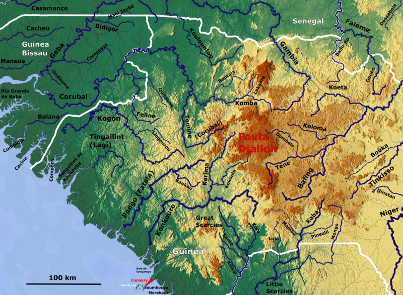
English: Map of Fouta Djallon with the major rivers_OSM, Based up on US Army map NC28-29 |
| Date | |
| Source | https://maps-for-free.com, https://maps.lib.utexas.edu/maps/imw/ |
| Author | Hans Braxmeier & Peter in s |
This file is licensed under the
Creative Commons
Attribution-Share Alike 2.0 Generic license.
- You are free:
- to share – to copy, distribute and transmit the work
- to remix – to adapt the work
- Under the following conditions:
- attribution – You must give appropriate credit, provide a link to the license, and indicate if changes were made. You may do so in any reasonable manner, but not in any way that suggests the licensor endorses you or your use.
- share alike – If you remix, transform, or build upon the material, you must distribute your contributions under the same or compatible license as the original.
File history
Click on a date/time to view the file as it appeared at that time.
| Date/Time | Thumbnail | Dimensions | User | Comment | |
|---|---|---|---|---|---|
| current | 11:23, 2 November 2019 |
| 2,435 × 1,787 (8.01 MB) | Peter in s | more sharp |
| 11:02, 2 November 2019 |
 | 2,435 × 1,787 (8.02 MB) | Peter in s | {{Information |description ={{en|1=Map of Fouta Djallon with the major rivers_OSM}} |date =2019-11-02 |source =https://maps-for-free.com/ |author =Hans Braxmeier & Peter in s }} {{cc-by-sa-2.0}} Category:Maps of rivers of Guinea Category:Geography of Guinea |
File usage
The following pages on the English Wikipedia use this file (pages on other projects are not listed):
Global file usage
The following other wikis use this file:
- Usage on ar.wikipedia.org
- Usage on bs.wikipedia.org
- Usage on de.wikipedia.org
- Usage on ha.wikipedia.org
- Usage on mg.wikipedia.org
- Usage on nl.wikipedia.org
- Usage on no.wikipedia.org
- Usage on ro.wikipedia.org
Metadata
Size of this preview:
800 × 587 pixels. Other resolutions:
320 × 235 pixels |
640 × 470 pixels |
1,024 × 751 pixels |
1,280 × 939 pixels |
2,435 × 1,787 pixels.
Original file (2,435 × 1,787 pixels, file size: 8.01 MB, MIME type: image/png)
| This is a file from the
Wikimedia Commons. Information from its
description page there is shown below. Commons is a freely licensed media file repository. You can help. |
Summary
| Description |
English: Map of Fouta Djallon with the major rivers_OSM, Based up on US Army map NC28-29 |
| Date | |
| Source | https://maps-for-free.com, https://maps.lib.utexas.edu/maps/imw/ |
| Author | Hans Braxmeier & Peter in s |
This file is licensed under the
Creative Commons
Attribution-Share Alike 2.0 Generic license.
- You are free:
- to share – to copy, distribute and transmit the work
- to remix – to adapt the work
- Under the following conditions:
- attribution – You must give appropriate credit, provide a link to the license, and indicate if changes were made. You may do so in any reasonable manner, but not in any way that suggests the licensor endorses you or your use.
- share alike – If you remix, transform, or build upon the material, you must distribute your contributions under the same or compatible license as the original.
File history
Click on a date/time to view the file as it appeared at that time.
| Date/Time | Thumbnail | Dimensions | User | Comment | |
|---|---|---|---|---|---|
| current | 11:23, 2 November 2019 |
| 2,435 × 1,787 (8.01 MB) | Peter in s | more sharp |
| 11:02, 2 November 2019 |
| 2,435 × 1,787 (8.02 MB) | Peter in s | {{Information |description ={{en|1=Map of Fouta Djallon with the major rivers_OSM}} |date =2019-11-02 |source =https://maps-for-free.com/ |author =Hans Braxmeier & Peter in s }} {{cc-by-sa-2.0}} Category:Maps of rivers of Guinea Category:Geography of Guinea |
File usage
The following pages on the English Wikipedia use this file (pages on other projects are not listed):
Global file usage
The following other wikis use this file:
- Usage on ar.wikipedia.org
- Usage on bs.wikipedia.org
- Usage on de.wikipedia.org
- Usage on ha.wikipedia.org
- Usage on mg.wikipedia.org
- Usage on nl.wikipedia.org
- Usage on no.wikipedia.org
- Usage on ro.wikipedia.org