Photos • Location


Size of this preview:
800 × 450 pixels. Other resolutions:
320 × 180 pixels |
640 × 360 pixels |
1,024 × 576 pixels |
1,280 × 720 pixels |
2,816 × 1,584 pixels.
Original file (2,816 × 1,584 pixels, file size: 2.58 MB, MIME type: image/jpeg)
| This is a file from the
Wikimedia Commons. Information from its
description page there is shown below. Commons is a freely licensed media file repository. You can help. |
| Camera location |
| View this and other nearby images on: OpenStreetMap |
|
|---|
| Object location |
| View this and other nearby images on: OpenStreetMap |
|
|---|
| Description |
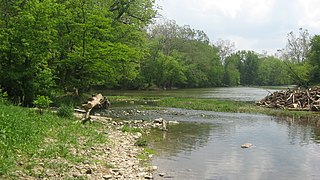
English: Surface-level view of the Forks of the Wabash: the confluence of the
Wabash River (right) with the
Little Wabash River (left), at the western edge of
Huntington,
Indiana,
United States. Picture looks eastward from the riverbank under the bridge carrying
State Road 9 over the Wabash. The site is part of the
historic district known as the
Chief Richardville House and Miami Treaty Grounds, which is listed on the
National Register of Historic Places. |
||
| Date | Taken on 8 May 2012 | ||
| Source | Own work | ||
| Author | Nyttend | ||
| Permission ( Reusing this file) |
|
| Annotations | This image is annotated: View the annotations at Commons |
File history
Click on a date/time to view the file as it appeared at that time.
| Date/Time | Thumbnail | Dimensions | User | Comment | |
|---|---|---|---|---|---|
| current | 16:13, 11 May 2012 |
| 2,816 × 1,584 (2.58 MB) | Nyttend | {{Location|40|52|35.4|N|85|31|56|W}} {{Object location|40|52|35|N|85|31|49|W}} {{Information |Description={{en|Surface-level view of the Forks of the Wabash: the confluence of the {{w|Wabash River}} (right) with the {{w|Little River (Indiana)|Little Wa... |
File usage
The following pages on the English Wikipedia use this file (pages on other projects are not listed):
Metadata
Size of this preview:
800 × 450 pixels. Other resolutions:
320 × 180 pixels |
640 × 360 pixels |
1,024 × 576 pixels |
1,280 × 720 pixels |
2,816 × 1,584 pixels.
Original file (2,816 × 1,584 pixels, file size: 2.58 MB, MIME type: image/jpeg)
| This is a file from the
Wikimedia Commons. Information from its
description page there is shown below. Commons is a freely licensed media file repository. You can help. |
| Camera location |
| View this and other nearby images on: OpenStreetMap |
|
|---|
| Object location |
| View this and other nearby images on: OpenStreetMap |
|
|---|
| Description |
English: Surface-level view of the Forks of the Wabash: the confluence of the
Wabash River (right) with the
Little Wabash River (left), at the western edge of
Huntington,
Indiana,
United States. Picture looks eastward from the riverbank under the bridge carrying
State Road 9 over the Wabash. The site is part of the
historic district known as the
Chief Richardville House and Miami Treaty Grounds, which is listed on the
National Register of Historic Places. |
||
| Date | Taken on 8 May 2012 | ||
| Source | Own work | ||
| Author | Nyttend | ||
| Permission ( Reusing this file) |
|
| Annotations | This image is annotated: View the annotations at Commons |
File history
Click on a date/time to view the file as it appeared at that time.
| Date/Time | Thumbnail | Dimensions | User | Comment | |
|---|---|---|---|---|---|
| current | 16:13, 11 May 2012 |
| 2,816 × 1,584 (2.58 MB) | Nyttend | {{Location|40|52|35.4|N|85|31|56|W}} {{Object location|40|52|35|N|85|31|49|W}} {{Information |Description={{en|Surface-level view of the Forks of the Wabash: the confluence of the {{w|Wabash River}} (right) with the {{w|Little River (Indiana)|Little Wa... |
File usage
The following pages on the English Wikipedia use this file (pages on other projects are not listed):