Photos • Location


No higher resolution available.
Fore_Street_Grampound_-_geograph.org.uk_-_1816580.jpg (640 × 480 pixels, file size: 97 KB, MIME type: image/jpeg)
| This is a file from the
Wikimedia Commons. Information from its
description page there is shown below. Commons is a freely licensed media file repository. You can help. |
Summary
| Description |
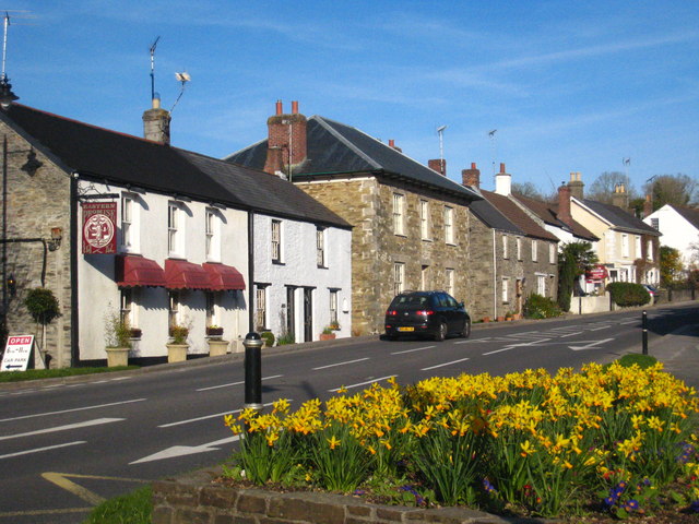
English: Fore Street Grampound, near to Grampound, Cornwall, Great Britain.
Grampound's linear layout is medieval, with long thin burgage plots extending away from the main street, Fore Street (A390). Most of the village core is a Conservation Area, and there are many listed buildings on Fore Street. Its name is from the Norman French grand (great) and pont (bridge) and it was an important crossing point on the River Fal. It was notorious as a rotten borough, returning two MPs to the House of Commons from the reign of Edward VI until it was disenfranchised in 1821, after a corruption scandal that led to the conviction and imprisonment of several people for bribery. |
| Date | |
| Source | From geograph.org.uk; transferred by User:Skinsmoke using geograph_org2commons. |
| Author | Rod Allday |
| Permission ( Reusing this file) |
Creative Commons Attribution Share-alike license 2.0 |
| Attribution ( required by the license) | Rod Allday / Fore Street Grampound / |
| Camera location | | View this and other nearby images on: OpenStreetMap |
|
|---|
| Object location | | View this and other nearby images on: OpenStreetMap |
|
|---|
_region:GB-GBN_heading:90.00&language=en)
Licensing

|
This image was taken from the
Geograph project collection. See
this photograph's page on the Geograph website for the photographer's contact details. The copyright on this image is owned by Rod Allday and is licensed for reuse under the
Creative Commons Attribution-ShareAlike 2.0 license.
|
This file is licensed under the
Creative Commons
Attribution-Share Alike 2.0 Generic license.
Attribution: Rod Allday
- You are free:
- to share – to copy, distribute and transmit the work
- to remix – to adapt the work
- Under the following conditions:
- attribution – You must give appropriate credit, provide a link to the license, and indicate if changes were made. You may do so in any reasonable manner, but not in any way that suggests the licensor endorses you or your use.
- share alike – If you remix, transform, or build upon the material, you must distribute your contributions under the same or compatible license as the original.
File history
Click on a date/time to view the file as it appeared at that time.
| Date/Time | Thumbnail | Dimensions | User | Comment | |
|---|---|---|---|---|---|
| current | 04:00, 24 September 2010 |
| 640 × 480 (97 KB) | File Upload Bot (Magnus Manske) | == {{int:filedesc}} == {{Information |Description={{en|1=Fore Street Grampound, near to Grampound, Cornwall, Great Britain. Grampound's linear layout is medieval, with long thin burgage plots extending away from the main street, Fore Street (A390). M |
File usage
The following pages on the English Wikipedia use this file (pages on other projects are not listed):
Global file usage
The following other wikis use this file:
- Usage on simple.wikipedia.org
- Usage on sv.wikipedia.org
- Usage on tr.wikipedia.org
Metadata
No higher resolution available.
Fore_Street_Grampound_-_geograph.org.uk_-_1816580.jpg (640 × 480 pixels, file size: 97 KB, MIME type: image/jpeg)
| This is a file from the
Wikimedia Commons. Information from its
description page there is shown below. Commons is a freely licensed media file repository. You can help. |
Summary
| Description |
English: Fore Street Grampound, near to Grampound, Cornwall, Great Britain.
Grampound's linear layout is medieval, with long thin burgage plots extending away from the main street, Fore Street (A390). Most of the village core is a Conservation Area, and there are many listed buildings on Fore Street. Its name is from the Norman French grand (great) and pont (bridge) and it was an important crossing point on the River Fal. It was notorious as a rotten borough, returning two MPs to the House of Commons from the reign of Edward VI until it was disenfranchised in 1821, after a corruption scandal that led to the conviction and imprisonment of several people for bribery. |
| Date | |
| Source | From geograph.org.uk; transferred by User:Skinsmoke using geograph_org2commons. |
| Author | Rod Allday |
| Permission ( Reusing this file) |
Creative Commons Attribution Share-alike license 2.0 |
| Attribution ( required by the license) | Rod Allday / Fore Street Grampound / |
| Camera location | | View this and other nearby images on: OpenStreetMap |
|
|---|
| Object location | | View this and other nearby images on: OpenStreetMap |
|
|---|
Licensing
|
|
This image was taken from the
Geograph project collection. See
this photograph's page on the Geograph website for the photographer's contact details. The copyright on this image is owned by Rod Allday and is licensed for reuse under the
Creative Commons Attribution-ShareAlike 2.0 license.
|
This file is licensed under the
Creative Commons
Attribution-Share Alike 2.0 Generic license.
Attribution: Rod Allday
- You are free:
- to share – to copy, distribute and transmit the work
- to remix – to adapt the work
- Under the following conditions:
- attribution – You must give appropriate credit, provide a link to the license, and indicate if changes were made. You may do so in any reasonable manner, but not in any way that suggests the licensor endorses you or your use.
- share alike – If you remix, transform, or build upon the material, you must distribute your contributions under the same or compatible license as the original.
File history
Click on a date/time to view the file as it appeared at that time.
| Date/Time | Thumbnail | Dimensions | User | Comment | |
|---|---|---|---|---|---|
| current | 04:00, 24 September 2010 |
| 640 × 480 (97 KB) | File Upload Bot (Magnus Manske) | == {{int:filedesc}} == {{Information |Description={{en|1=Fore Street Grampound, near to Grampound, Cornwall, Great Britain. Grampound's linear layout is medieval, with long thin burgage plots extending away from the main street, Fore Street (A390). M |
File usage
The following pages on the English Wikipedia use this file (pages on other projects are not listed):
Global file usage
The following other wikis use this file:
- Usage on simple.wikipedia.org
- Usage on sv.wikipedia.org
- Usage on tr.wikipedia.org