Size of this preview:
341 × 600 pixels. Other resolutions:
136 × 240 pixels |
455 × 800 pixels.
Original file (455 × 800 pixels, file size: 108 KB, MIME type: image/png)
| This is a file from the
Wikimedia Commons. Information from its
description page there is shown below. Commons is a freely licensed media file repository. You can help. |
Summary
| Description |
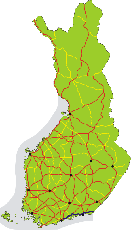
English: Map of the main road 7 in Finland, shown in dark blue. The other 1st class main roads (numbers 1–29) are red, 2nd class main roads (numbers 40–98) yellow. Black dots show the 12 biggest urban areas.
Suomi:
Valtatie 7 on merkitty karttaan tummansinisellä. Muut
valtatiet (numerot 1–29) on merkitty karttaan punaisella,
kantatiet (numerot 40–98) keltaisella. Tärkeimmät kaupunkiseudut on merkitty mustilla pisteillä. |
| Date | |
| Source | Own work |
| Author | Migro |
Licensing
| I, the copyright holder of this work, release this work into the
public domain. This applies worldwide. In some countries this may not be legally possible; if so: I grant anyone the right to use this work for any purpose, without any conditions, unless such conditions are required by law. |
File history
Click on a date/time to view the file as it appeared at that time.
| Date/Time | Thumbnail | Dimensions | User | Comment | |
|---|---|---|---|---|---|
| current | 21:02, 1 July 2007 |
| 455 × 800 (108 KB) | Migro | == Summary == {{Information |Description=Map of main road 7 in Finland, shown in dark blue. Roads 1-29 are red, 40-98 are yellow. Black dots show the 12 biggest urban areas. |Source=self-made |Date=2007-07-01 |Author= Migro }} [[Category: |
File usage
The following pages on the English Wikipedia use this file (pages on other projects are not listed):
Global file usage
The following other wikis use this file:
- Usage on cs.wikipedia.org
- Usage on de.wikipedia.org
- Usage on fi.wikipedia.org
- Usage on fr.wikipedia.org
- Usage on it.wikipedia.org
- Usage on ko.wikipedia.org
- Usage on lmo.wikipedia.org
- Usage on no.wikipedia.org
- Usage on ru.wikipedia.org
- Usage on sv.wikipedia.org
- Usage on uk.wikipedia.org
- Usage on www.wikidata.org
- Usage on zh.wikipedia.org
Size of this preview:
341 × 600 pixels. Other resolutions:
136 × 240 pixels |
455 × 800 pixels.
Original file (455 × 800 pixels, file size: 108 KB, MIME type: image/png)
| This is a file from the
Wikimedia Commons. Information from its
description page there is shown below. Commons is a freely licensed media file repository. You can help. |
Summary
| Description |
English: Map of the main road 7 in Finland, shown in dark blue. The other 1st class main roads (numbers 1–29) are red, 2nd class main roads (numbers 40–98) yellow. Black dots show the 12 biggest urban areas.
Suomi:
Valtatie 7 on merkitty karttaan tummansinisellä. Muut
valtatiet (numerot 1–29) on merkitty karttaan punaisella,
kantatiet (numerot 40–98) keltaisella. Tärkeimmät kaupunkiseudut on merkitty mustilla pisteillä. |
| Date | |
| Source | Own work |
| Author | Migro |
Licensing
| I, the copyright holder of this work, release this work into the
public domain. This applies worldwide. In some countries this may not be legally possible; if so: I grant anyone the right to use this work for any purpose, without any conditions, unless such conditions are required by law. |
File history
Click on a date/time to view the file as it appeared at that time.
| Date/Time | Thumbnail | Dimensions | User | Comment | |
|---|---|---|---|---|---|
| current | 21:02, 1 July 2007 |
| 455 × 800 (108 KB) | Migro | == Summary == {{Information |Description=Map of main road 7 in Finland, shown in dark blue. Roads 1-29 are red, 40-98 are yellow. Black dots show the 12 biggest urban areas. |Source=self-made |Date=2007-07-01 |Author= Migro }} [[Category: |
File usage
The following pages on the English Wikipedia use this file (pages on other projects are not listed):
Global file usage
The following other wikis use this file:
- Usage on cs.wikipedia.org
- Usage on de.wikipedia.org
- Usage on fi.wikipedia.org
- Usage on fr.wikipedia.org
- Usage on it.wikipedia.org
- Usage on ko.wikipedia.org
- Usage on lmo.wikipedia.org
- Usage on no.wikipedia.org
- Usage on ru.wikipedia.org
- Usage on sv.wikipedia.org
- Usage on uk.wikipedia.org
- Usage on www.wikidata.org
- Usage on zh.wikipedia.org