
Size of this preview:
751 × 600 pixels. Other resolutions:
301 × 240 pixels |
601 × 480 pixels |
962 × 768 pixels |
1,200 × 958 pixels.
Original file (1,200 × 958 pixels, file size: 598 KB, MIME type: image/png)
| This is a file from the
Wikimedia Commons. Information from its
description page there is shown below. Commons is a freely licensed media file repository. You can help. |

|
This linguistic map image could be re-created using
vector graphics as an
SVG file. This has several advantages; see
Commons:Media for cleanup for more information. If an SVG form of this image is available, please upload it and afterwards replace this template with
{{
vector version available|new image name}}
.
It is recommended to name the SVG file “Euskalkiak koldo zuazo 2008.svg”—then the template Vector version available (or Vva) does not need the new image name parameter. |
Summary
| Description |
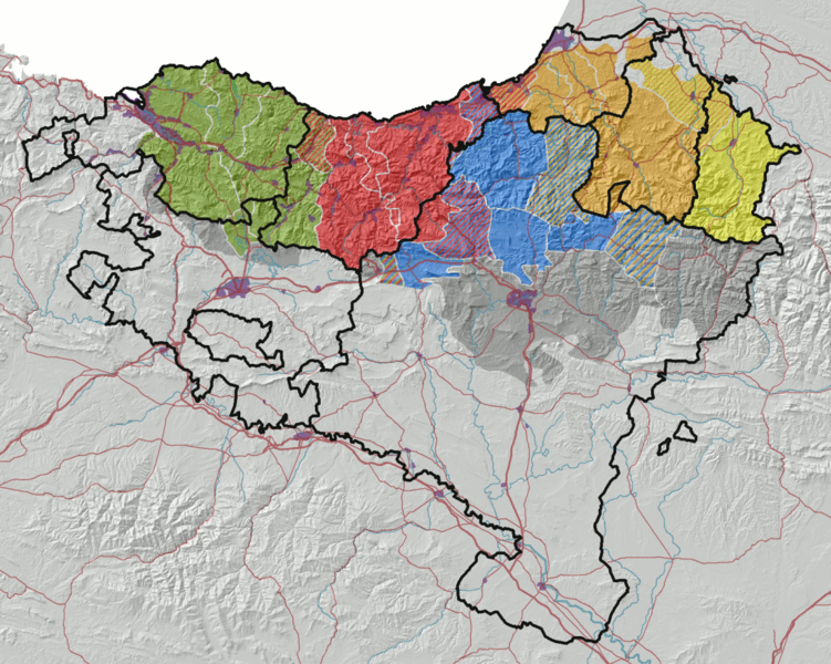
English: Modern map of Basque dialects, developed by Koldo Zuazo:
Western dialect
Central dialect
Navarrese
Navarrese-lapurdian
Dialect of Soule
Basque speaking places in the 19th century (according to
Louis-Lucien Bonaparte's map) Esperanto: Mapo montranta la nunan distribuon de la eŭskaj dialektoj, laŭ Koldo Zuazo:
Okcidenta dialekto
Centra dialekto
Navara dialekto
Navar-lapurda dialekto
Suleta dialekto
Hispanparolantaj zonoj kiuj estis eŭskparalantaj en la 19a jarcento (laŭ
la mapo de Louis-Lucien Bonaparte) Català: Mapa mostrant la distribució contemporània dels dialectes de l'euskera, segons Koldo Zuazo:
dialecte occidental
dialecte central
dialecte navarrès
dialecte navarro-labortà
dialecte suletí
àrees hispanòfones que foren vascòfones al segle XIX (d'acord amb
el mapa de Louis-Lucien Bonaparte) Español: Mapa mostrando la distribución actual de los dialectos del euskera, según Koldo Zuazo:
dialecto occidental
dialecto central
dialecto navarro
dialecto navarro-labortano
dialecto suletino
zonas hispanófonas que eran vascófonas en el siglo XIX (de acuerdo con
el mapa de Louis-Lucien Bonaparte) Euskara: Koldo Zuazok atondutako euskalkien mapa modernoa:
Mendebalekoa
Erdialdekoa
Nafarra
Nafar-lapurtarra
Zuberotarra
XIX. mendean euskal hiztunak zituzten eremuak (
Luis Luziano Bonapartek egindako maparen arabera) Français : Carte montrant la distribution actuelle des dialectes basques selon Koldo Zuazo:
dialecte occidental
dialecte central
dialecte navarrais
dialecte navarro-labourdin
dialecte souletin
zones hispanophones qui étaient bascophones au XIXe siècle (selon
la carte de Louis-Lucien Bonaparte) Português: Mapa da distribuição atual dos
dialetos bascos, segundo Koldo Zuazo:
dialeto ocidental
dialeto central
dialeto navarro
dialeto navarro-labortano
dialeto suletino
áreas hispanófonas que eram vascófonas no século XIX (de acordo com o
mapa de Louis-Lucien Bonaparte) |
| Source |
|
| Author | Asier Sarasua Garmendia, Assar |
| Other versions | Derivative works of this file: Euskalkiak koldo zuazo 2008 euskara.png |
Licensing
| I, the copyright holder of this work, release this work into the
public domain. This applies worldwide. In some countries this may not be legally possible; if so: I grant anyone the right to use this work for any purpose, without any conditions, unless such conditions are required by law. |
File history
Click on a date/time to view the file as it appeared at that time.
| Date/Time | Thumbnail | Dimensions | User | Comment | |
|---|---|---|---|---|---|
| current | 20:05, 26 September 2008 |
| 1,200 × 958 (598 KB) | Assar | {{Information |Description={{eu|1=Koldo Zuazok atondutako euskalkien mapa modernoa}} |Source=*DEM: SRTM3 published by the NASA (http://seamless.usgs.gov) *Cities: own work, digitalization based on Landsat imagery (http://www.landsat.org) *Rivers: own work |
File usage
The following pages on the English Wikipedia use this file (pages on other projects are not listed):
Global file usage
The following other wikis use this file:
- Usage on an.wikipedia.org
- Usage on ast.wikipedia.org
- Usage on ast.wiktionary.org
- Usage on br.wikipedia.org
- Usage on ca.wikipedia.org
- Usage on de.wikipedia.org
- Usage on eo.wikipedia.org
- Usage on es.wikipedia.org
- Usage on eu.wikipedia.org
- Euskara batua
- Mendebaleko euskara
- Euskara
- Euskalki
- Euskararen historia
- Kategoria:Euskalkiak
- Zuberera
- Gipuzkera
- Nafar-lapurtera
- Erronkariera
- Aitzineuskara
- Isoglosa
- Zerrenda:Euskalkiak eta azpieuskalkiak
- Ekialdeko nafar euskalkia
- Akitaniera
- Arabako euskara
- Erroibarrera
- Euskal literatura
- Goi-nafarrera
- Euskal Pizkundea
- Esteribarrera
- Donemiliagako glosak
- Euskal Herriko hizkuntzak
- Euskara Bigarren Mundu Gerran
- Euskararen ahaideak
- Euskalgintza
- Txantiloi:Euskalkiak
- Hegoaldeko goi nafarrera
- Eztabaida:Beterriko gipuzkera
- Txantiloi:Euskalkiak2008
- Atari:Euskara
- Atari:Euskara/Historia
- Codex Calixtinus
- Euskararen debekua
- Txantiloi:2011-44 Nabarmendutakoa
View more global usage of this file.
Size of this preview:
751 × 600 pixels. Other resolutions:
301 × 240 pixels |
601 × 480 pixels |
962 × 768 pixels |
1,200 × 958 pixels.
Original file (1,200 × 958 pixels, file size: 598 KB, MIME type: image/png)
| This is a file from the
Wikimedia Commons. Information from its
description page there is shown below. Commons is a freely licensed media file repository. You can help. |
|
|
This linguistic map image could be re-created using
vector graphics as an
SVG file. This has several advantages; see
Commons:Media for cleanup for more information. If an SVG form of this image is available, please upload it and afterwards replace this template with
{{
vector version available|new image name}}
.
It is recommended to name the SVG file “Euskalkiak koldo zuazo 2008.svg”—then the template Vector version available (or Vva) does not need the new image name parameter. |
Summary
| Description |
English: Modern map of Basque dialects, developed by Koldo Zuazo:
Western dialect
Central dialect
Navarrese
Navarrese-lapurdian
Dialect of Soule
Basque speaking places in the 19th century (according to
Louis-Lucien Bonaparte's map) Esperanto: Mapo montranta la nunan distribuon de la eŭskaj dialektoj, laŭ Koldo Zuazo:
Okcidenta dialekto
Centra dialekto
Navara dialekto
Navar-lapurda dialekto
Suleta dialekto
Hispanparolantaj zonoj kiuj estis eŭskparalantaj en la 19a jarcento (laŭ
la mapo de Louis-Lucien Bonaparte) Català: Mapa mostrant la distribució contemporània dels dialectes de l'euskera, segons Koldo Zuazo:
dialecte occidental
dialecte central
dialecte navarrès
dialecte navarro-labortà
dialecte suletí
àrees hispanòfones que foren vascòfones al segle XIX (d'acord amb
el mapa de Louis-Lucien Bonaparte) Español: Mapa mostrando la distribución actual de los dialectos del euskera, según Koldo Zuazo:
dialecto occidental
dialecto central
dialecto navarro
dialecto navarro-labortano
dialecto suletino
zonas hispanófonas que eran vascófonas en el siglo XIX (de acuerdo con
el mapa de Louis-Lucien Bonaparte) Euskara: Koldo Zuazok atondutako euskalkien mapa modernoa:
Mendebalekoa
Erdialdekoa
Nafarra
Nafar-lapurtarra
Zuberotarra
XIX. mendean euskal hiztunak zituzten eremuak (
Luis Luziano Bonapartek egindako maparen arabera) Français : Carte montrant la distribution actuelle des dialectes basques selon Koldo Zuazo:
dialecte occidental
dialecte central
dialecte navarrais
dialecte navarro-labourdin
dialecte souletin
zones hispanophones qui étaient bascophones au XIXe siècle (selon
la carte de Louis-Lucien Bonaparte) Português: Mapa da distribuição atual dos
dialetos bascos, segundo Koldo Zuazo:
dialeto ocidental
dialeto central
dialeto navarro
dialeto navarro-labortano
dialeto suletino
áreas hispanófonas que eram vascófonas no século XIX (de acordo com o
mapa de Louis-Lucien Bonaparte) |
| Source |
|
| Author | Asier Sarasua Garmendia, Assar |
| Other versions | Derivative works of this file: Euskalkiak koldo zuazo 2008 euskara.png |
Licensing
| I, the copyright holder of this work, release this work into the
public domain. This applies worldwide. In some countries this may not be legally possible; if so: I grant anyone the right to use this work for any purpose, without any conditions, unless such conditions are required by law. |
File history
Click on a date/time to view the file as it appeared at that time.
| Date/Time | Thumbnail | Dimensions | User | Comment | |
|---|---|---|---|---|---|
| current | 20:05, 26 September 2008 |
| 1,200 × 958 (598 KB) | Assar | {{Information |Description={{eu|1=Koldo Zuazok atondutako euskalkien mapa modernoa}} |Source=*DEM: SRTM3 published by the NASA (http://seamless.usgs.gov) *Cities: own work, digitalization based on Landsat imagery (http://www.landsat.org) *Rivers: own work |
File usage
The following pages on the English Wikipedia use this file (pages on other projects are not listed):
Global file usage
The following other wikis use this file:
- Usage on an.wikipedia.org
- Usage on ast.wikipedia.org
- Usage on ast.wiktionary.org
- Usage on br.wikipedia.org
- Usage on ca.wikipedia.org
- Usage on de.wikipedia.org
- Usage on eo.wikipedia.org
- Usage on es.wikipedia.org
- Usage on eu.wikipedia.org
- Euskara batua
- Mendebaleko euskara
- Euskara
- Euskalki
- Euskararen historia
- Kategoria:Euskalkiak
- Zuberera
- Gipuzkera
- Nafar-lapurtera
- Erronkariera
- Aitzineuskara
- Isoglosa
- Zerrenda:Euskalkiak eta azpieuskalkiak
- Ekialdeko nafar euskalkia
- Akitaniera
- Arabako euskara
- Erroibarrera
- Euskal literatura
- Goi-nafarrera
- Euskal Pizkundea
- Esteribarrera
- Donemiliagako glosak
- Euskal Herriko hizkuntzak
- Euskara Bigarren Mundu Gerran
- Euskararen ahaideak
- Euskalgintza
- Txantiloi:Euskalkiak
- Hegoaldeko goi nafarrera
- Eztabaida:Beterriko gipuzkera
- Txantiloi:Euskalkiak2008
- Atari:Euskara
- Atari:Euskara/Historia
- Codex Calixtinus
- Euskararen debekua
- Txantiloi:2011-44 Nabarmendutakoa
View more global usage of this file.