Photos • Location


Size of this preview:
800 × 192 pixels. Other resolutions:
320 × 77 pixels |
640 × 153 pixels |
1,024 × 245 pixels |
3,337 × 800 pixels.
Original file (3,337 × 800 pixels, file size: 907 KB, MIME type: image/jpeg)
| This is a file from the
Wikimedia Commons. Information from its
description page there is shown below. Commons is a freely licensed media file repository. You can help. |
Summary
| Description |
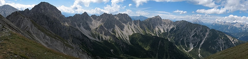
Deutsch: Westseite der
Erlspitzgruppe (
Karwendel) von N (Maderkarlspitze): Von links (O) nach rechts (W):
Großer Solstein,
Erlspitze, Kuhljochspitze, Freiungen, Reitherspitze, Seefelder Spitze, Seefelder Joch, Hohe Munde (Mieminger), Zugspitzplatt und Wettersteinhauptkamm |
| Date | |
| Source | photo taken by Kogo |
| Author | Kogo |
| Permission ( Reusing this file) |
GFDL |
| Camera location |
| View this and other nearby images on: OpenStreetMap |
|
|---|
Licensing
I, the copyright holder of this work, hereby publish it under the following license:

|
Permission is granted to copy, distribute and/or modify this document under the terms of the GNU Free Documentation License, Version 1.2 or any later version published by the Free Software Foundation; with no Invariant Sections, no Front-Cover Texts, and no Back-Cover Texts. A copy of the license is included in the section entitled GNU Free Documentation License. |
| Annotations | This image is annotated: View the annotations at Commons |
File history
Click on a date/time to view the file as it appeared at that time.
| Date/Time | Thumbnail | Dimensions | User | Comment | |
|---|---|---|---|---|---|
| current | 21:56, 10 December 2007 |
| 3,337 × 800 (907 KB) | Kogo | {{Information |Description=Erlspitzgruppe (Karwendel) |Source=photo taken by Kogo |Date=26. August 2006 |Author= Kogo |Permission=GFDL |other_versions= }} |
File usage
The following pages on the English Wikipedia use this file (pages on other projects are not listed):
Global file usage
The following other wikis use this file:
- Usage on de.wikipedia.org
- Usage on es.wikipedia.org
- Usage on nl.wikipedia.org
Metadata
Size of this preview:
800 × 192 pixels. Other resolutions:
320 × 77 pixels |
640 × 153 pixels |
1,024 × 245 pixels |
3,337 × 800 pixels.
Original file (3,337 × 800 pixels, file size: 907 KB, MIME type: image/jpeg)
| This is a file from the
Wikimedia Commons. Information from its
description page there is shown below. Commons is a freely licensed media file repository. You can help. |
Summary
| Description |
Deutsch: Westseite der
Erlspitzgruppe (
Karwendel) von N (Maderkarlspitze): Von links (O) nach rechts (W):
Großer Solstein,
Erlspitze, Kuhljochspitze, Freiungen, Reitherspitze, Seefelder Spitze, Seefelder Joch, Hohe Munde (Mieminger), Zugspitzplatt und Wettersteinhauptkamm |
| Date | |
| Source | photo taken by Kogo |
| Author | Kogo |
| Permission ( Reusing this file) |
GFDL |
| Camera location |
| View this and other nearby images on: OpenStreetMap |
|
|---|
Licensing
I, the copyright holder of this work, hereby publish it under the following license:
|
|
Permission is granted to copy, distribute and/or modify this document under the terms of the GNU Free Documentation License, Version 1.2 or any later version published by the Free Software Foundation; with no Invariant Sections, no Front-Cover Texts, and no Back-Cover Texts. A copy of the license is included in the section entitled GNU Free Documentation License. |
| Annotations | This image is annotated: View the annotations at Commons |
File history
Click on a date/time to view the file as it appeared at that time.
| Date/Time | Thumbnail | Dimensions | User | Comment | |
|---|---|---|---|---|---|
| current | 21:56, 10 December 2007 |
| 3,337 × 800 (907 KB) | Kogo | {{Information |Description=Erlspitzgruppe (Karwendel) |Source=photo taken by Kogo |Date=26. August 2006 |Author= Kogo |Permission=GFDL |other_versions= }} |
File usage
The following pages on the English Wikipedia use this file (pages on other projects are not listed):
Global file usage
The following other wikis use this file:
- Usage on de.wikipedia.org
- Usage on es.wikipedia.org
- Usage on nl.wikipedia.org