
Original file (2,149 × 1,405 pixels, file size: 2.06 MB, MIME type: image/jpeg)
| This is a file from the
Wikimedia Commons. Information from its
description page there is shown below. Commons is a freely licensed media file repository. You can help. |
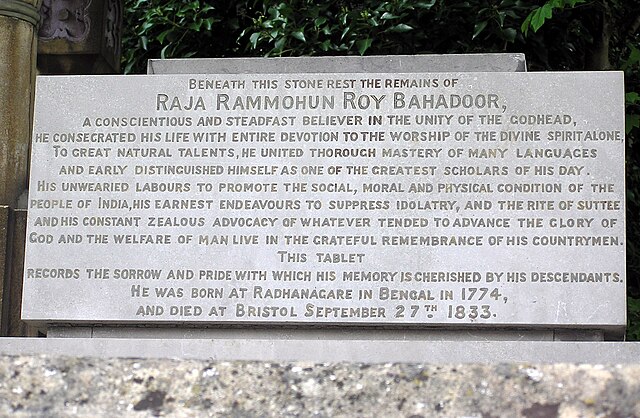
| Description | Gravestone of Raja at Arno’s Vale Cemetery in Bristol, England. | ||
| Date | May 2005 (2 May 2005 (according to Exif data)) | ||
| Source | Photographed by Adrian Pingstone | ||
| Author | Arpingstone | ||
| Permission ( Reusing this file) |
|
| Camera location | | View this and other nearby images on: OpenStreetMap |
|
|---|
File history
Click on a date/time to view the file as it appeared at that time.
| Date/Time | Thumbnail | Dimensions | User | Comment | |
|---|---|---|---|---|---|
| current | 21:35, 23 February 2007 |
| 2,149 × 1,405 (2.06 MB) | Arpingstone | Epitaph |
File usage
Global file usage
The following other wikis use this file:
- Usage on es.wikipedia.org
- Usage on kn.wikipedia.org
- Usage on te.wikipedia.org
Metadata
Original file (2,149 × 1,405 pixels, file size: 2.06 MB, MIME type: image/jpeg)
| This is a file from the
Wikimedia Commons. Information from its
description page there is shown below. Commons is a freely licensed media file repository. You can help. |
| Description | Gravestone of Raja at Arno’s Vale Cemetery in Bristol, England. | ||
| Date | May 2005 (2 May 2005 (according to Exif data)) | ||
| Source | Photographed by Adrian Pingstone | ||
| Author | Arpingstone | ||
| Permission ( Reusing this file) |
|
| Camera location | | View this and other nearby images on: OpenStreetMap |
|
|---|
File history
Click on a date/time to view the file as it appeared at that time.
| Date/Time | Thumbnail | Dimensions | User | Comment | |
|---|---|---|---|---|---|
| current | 21:35, 23 February 2007 |
| 2,149 × 1,405 (2.06 MB) | Arpingstone | Epitaph |
File usage
Global file usage
The following other wikis use this file:
- Usage on es.wikipedia.org
- Usage on kn.wikipedia.org
- Usage on te.wikipedia.org