
Size of this preview:
488 × 600 pixels. Other resolutions:
195 × 240 pixels |
391 × 480 pixels |
625 × 768 pixels |
833 × 1,024 pixels |
1,667 × 2,048 pixels |
5,300 × 6,512 pixels.
Original file (5,300 × 6,512 pixels, file size: 3.07 MB, MIME type: image/jpeg)
| This is a file from the
Wikimedia Commons. Information from its
description page there is shown below. Commons is a freely licensed media file repository. You can help. |
Summary
| Description |
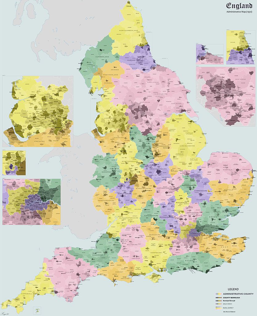
English: Administrative map of England in 1931. Shows Administrative Counties, County Boroughs, Municipal Boroughs, Urban and Rural Districts. |
| Date | |
| Source | Own work |
| Author | XrysD |
| Other versions | Derivative works of this file: England Administrative 1931 Unlabelled.png |
Licensing
I, the copyright holder of this work, hereby publish it under the following licenses:
This file is licensed under the
Creative Commons
Attribution-Share Alike 3.0 Unported license.
- You are free:
- to share – to copy, distribute and transmit the work
- to remix – to adapt the work
- Under the following conditions:
- attribution – You must give appropriate credit, provide a link to the license, and indicate if changes were made. You may do so in any reasonable manner, but not in any way that suggests the licensor endorses you or your use.
- share alike – If you remix, transform, or build upon the material, you must distribute your contributions under the same or compatible license as the original.

|
Permission is granted to copy, distribute and/or modify this document under the terms of the GNU Free Documentation License, Version 1.2 or any later version published by the Free Software Foundation; with no Invariant Sections, no Front-Cover Texts, and no Back-Cover Texts. A copy of the license is included in the section entitled GNU Free Documentation License. |
You may select the license of your choice.
File history
Click on a date/time to view the file as it appeared at that time.
| Date/Time | Thumbnail | Dimensions | User | Comment | |
|---|---|---|---|---|---|
| current | 20:23, 6 May 2011 |
| 5,300 × 6,512 (3.07 MB) | XrysD | 1) Labelled district to the west of Wolverhampton CB (Tettenhall UD) 2) District wrongly labelled as Tettenhall MB changed to Brownhills UD. 3) Aldridge changed to UD 4) District between Smethwick CB and and Rowley Regis UD wrongly labelled as Bebington |
| 11:24, 27 November 2010 |
 | 5,300 × 6,512 (3.06 MB) | XrysD | Fixed some typos in Hampshire. | |
| 18:52, 20 August 2010 |
 | 5,300 × 6,512 (7.51 MB) | XrysD | {{Information |Description={{en|1=Administrative map of England in 1931. Shows Administrative Counties, County Boroughs, Municipal Boroughs, Urban and Rural Districts.}} |Source={{own}} |Author= XrysD |Date=2010-08-20 |Permission= |other_ver |
File usage
The following pages on the English Wikipedia use this file (pages on other projects are not listed):
Global file usage
The following other wikis use this file:
- Usage on it.wikipedia.org
- Usage on lv.wikipedia.org
- Usage on nl.wikipedia.org
- Usage on simple.wikipedia.org
- Usage on uk.wikipedia.org
Metadata
Size of this preview:
488 × 600 pixels. Other resolutions:
195 × 240 pixels |
391 × 480 pixels |
625 × 768 pixels |
833 × 1,024 pixels |
1,667 × 2,048 pixels |
5,300 × 6,512 pixels.
Original file (5,300 × 6,512 pixels, file size: 3.07 MB, MIME type: image/jpeg)
| This is a file from the
Wikimedia Commons. Information from its
description page there is shown below. Commons is a freely licensed media file repository. You can help. |
Summary
| Description |
English: Administrative map of England in 1931. Shows Administrative Counties, County Boroughs, Municipal Boroughs, Urban and Rural Districts. |
| Date | |
| Source | Own work |
| Author | XrysD |
| Other versions | Derivative works of this file: England Administrative 1931 Unlabelled.png |
Licensing
I, the copyright holder of this work, hereby publish it under the following licenses:
This file is licensed under the
Creative Commons
Attribution-Share Alike 3.0 Unported license.
- You are free:
- to share – to copy, distribute and transmit the work
- to remix – to adapt the work
- Under the following conditions:
- attribution – You must give appropriate credit, provide a link to the license, and indicate if changes were made. You may do so in any reasonable manner, but not in any way that suggests the licensor endorses you or your use.
- share alike – If you remix, transform, or build upon the material, you must distribute your contributions under the same or compatible license as the original.
|
|
Permission is granted to copy, distribute and/or modify this document under the terms of the GNU Free Documentation License, Version 1.2 or any later version published by the Free Software Foundation; with no Invariant Sections, no Front-Cover Texts, and no Back-Cover Texts. A copy of the license is included in the section entitled GNU Free Documentation License. |
You may select the license of your choice.
File history
Click on a date/time to view the file as it appeared at that time.
| Date/Time | Thumbnail | Dimensions | User | Comment | |
|---|---|---|---|---|---|
| current | 20:23, 6 May 2011 |
| 5,300 × 6,512 (3.07 MB) | XrysD | 1) Labelled district to the west of Wolverhampton CB (Tettenhall UD) 2) District wrongly labelled as Tettenhall MB changed to Brownhills UD. 3) Aldridge changed to UD 4) District between Smethwick CB and and Rowley Regis UD wrongly labelled as Bebington |
| 11:24, 27 November 2010 |
| 5,300 × 6,512 (3.06 MB) | XrysD | Fixed some typos in Hampshire. | |
| 18:52, 20 August 2010 |
| 5,300 × 6,512 (7.51 MB) | XrysD | {{Information |Description={{en|1=Administrative map of England in 1931. Shows Administrative Counties, County Boroughs, Municipal Boroughs, Urban and Rural Districts.}} |Source={{own}} |Author= XrysD |Date=2010-08-20 |Permission= |other_ver |
File usage
The following pages on the English Wikipedia use this file (pages on other projects are not listed):
Global file usage
The following other wikis use this file:
- Usage on it.wikipedia.org
- Usage on lv.wikipedia.org
- Usage on nl.wikipedia.org
- Usage on simple.wikipedia.org
- Usage on uk.wikipedia.org