No higher resolution available.
EnglandDorset.png (197 × 244 pixels, file size: 20 KB, MIME type: image/png)
| This is a file from the
Wikimedia Commons. Information from its
description page there is shown below. Commons is a freely licensed media file repository. You can help. |

|
File:EnglandDorset.svg is a vector version of this file. It should be used in place of this PNG file when not inferior.
File:EnglandDorset.png →
File:EnglandDorset.svg
For more information, see
Help:SVG. |
 |
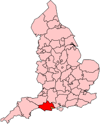
From en:Image:EnglandDorset.png
map of admin county

|
Permission is granted to copy, distribute and/or modify this document under the terms of the GNU Free Documentation License, Version 1.2 or any later version published by the Free Software Foundation; with no Invariant Sections, no Front-Cover Texts, and no Back-Cover Texts. A copy of the license is included in the section entitled GNU Free Documentation License. |
| This file is licensed under the Creative Commons Attribution-Share Alike 3.0 Unported license. | ||
| ||
| This licensing tag was added to this file as part of the GFDL licensing update. |
File history
Click on a date/time to view the file as it appeared at that time.
| Date/Time | Thumbnail | Dimensions | User | Comment | |
|---|---|---|---|---|---|
| current | 18:41, 20 December 2007 |
| 197 × 244 (20 KB) | Mahahahaneapneap | pngcrushed |
| 17:16, 9 April 2007 |
 | 197 × 244 (30 KB) | Steinsky | removed background | |
| 16:19, 20 June 2005 |
 | 200 × 247 (22 KB) | Airunp | From en:Image:EnglandDorset.png map of admin county {{GFDL}} Category:Maps of England es:Dorset en:Dorset |
File usage
The following pages on the English Wikipedia use this file (pages on other projects are not listed):
Global file usage
The following other wikis use this file:
- Usage on no.wikipedia.org
No higher resolution available.
EnglandDorset.png (197 × 244 pixels, file size: 20 KB, MIME type: image/png)
| This is a file from the
Wikimedia Commons. Information from its
description page there is shown below. Commons is a freely licensed media file repository. You can help. |
|
|
File:EnglandDorset.svg is a vector version of this file. It should be used in place of this PNG file when not inferior.
File:EnglandDorset.png →
File:EnglandDorset.svg
For more information, see
Help:SVG. |
|
From en:Image:EnglandDorset.png
map of admin county
|
|
Permission is granted to copy, distribute and/or modify this document under the terms of the GNU Free Documentation License, Version 1.2 or any later version published by the Free Software Foundation; with no Invariant Sections, no Front-Cover Texts, and no Back-Cover Texts. A copy of the license is included in the section entitled GNU Free Documentation License. |
| This file is licensed under the Creative Commons Attribution-Share Alike 3.0 Unported license. | ||
| ||
| This licensing tag was added to this file as part of the GFDL licensing update. |
File history
Click on a date/time to view the file as it appeared at that time.
| Date/Time | Thumbnail | Dimensions | User | Comment | |
|---|---|---|---|---|---|
| current | 18:41, 20 December 2007 |
| 197 × 244 (20 KB) | Mahahahaneapneap | pngcrushed |
| 17:16, 9 April 2007 |
| 197 × 244 (30 KB) | Steinsky | removed background | |
| 16:19, 20 June 2005 |
| 200 × 247 (22 KB) | Airunp | From en:Image:EnglandDorset.png map of admin county {{GFDL}} Category:Maps of England es:Dorset en:Dorset |
File usage
The following pages on the English Wikipedia use this file (pages on other projects are not listed):
Global file usage
The following other wikis use this file:
- Usage on no.wikipedia.org