
Original file (SVG file, nominally 1,604 × 1,280 pixels, file size: 260 KB)
| This is a file from the
Wikimedia Commons. Information from its
description page there is shown below. Commons is a freely licensed media file repository. You can help. |
| Description |
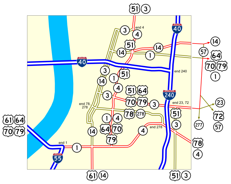
Map of numbered routes in downtown Memphis, Tennessee. Traced on USGS topos.
|
||
| Source | http://www.tdot.state.tn.us/ | ||
| Author | User:SPUI | ||
| Permission ( Reusing this file) |
|
||
| Other versions | Image:Downtown Memphis.png |
File history
Click on a date/time to view the file as it appeared at that time.
| Date/Time | Thumbnail | Dimensions | User | Comment | |
|---|---|---|---|---|---|
| current | 08:27, 19 August 2007 |
| 1,604 × 1,280 (260 KB) | NE2 | Why did this show SR 14 ending in Memphis? |
| 05:08, 17 May 2006 |
 | 1,604 × 1,280 (248 KB) | SPUI~commonswiki | ||
| 04:59, 17 May 2006 |
 | 1,596 × 1,268 (2.44 MB) | SPUI~commonswiki | {{spuimap}} Map of numbered routes in downtown Memphis, Tennessee. Traced on USGS topos. Information is from [http://www.tdot.state.tn.us/Maps/city/Memphis%20DT.PDF]. *Blue: Interstate *Red: Primary *Yellow: Secondary Category:road maps [[Category:Mem |
File usage
Global file usage
The following other wikis use this file:
- Usage on ja.wikipedia.org
- Usage on ko.wikipedia.org
Original file (SVG file, nominally 1,604 × 1,280 pixels, file size: 260 KB)
| This is a file from the
Wikimedia Commons. Information from its
description page there is shown below. Commons is a freely licensed media file repository. You can help. |
| Description |
Map of numbered routes in downtown Memphis, Tennessee. Traced on USGS topos.
|
||
| Source | http://www.tdot.state.tn.us/ | ||
| Author | User:SPUI | ||
| Permission ( Reusing this file) |
|
||
| Other versions | Image:Downtown Memphis.png |
File history
Click on a date/time to view the file as it appeared at that time.
| Date/Time | Thumbnail | Dimensions | User | Comment | |
|---|---|---|---|---|---|
| current | 08:27, 19 August 2007 |
| 1,604 × 1,280 (260 KB) | NE2 | Why did this show SR 14 ending in Memphis? |
| 05:08, 17 May 2006 |
| 1,604 × 1,280 (248 KB) | SPUI~commonswiki | ||
| 04:59, 17 May 2006 |
| 1,596 × 1,268 (2.44 MB) | SPUI~commonswiki | {{spuimap}} Map of numbered routes in downtown Memphis, Tennessee. Traced on USGS topos. Information is from [http://www.tdot.state.tn.us/Maps/city/Memphis%20DT.PDF]. *Blue: Interstate *Red: Primary *Yellow: Secondary Category:road maps [[Category:Mem |
File usage
Global file usage
The following other wikis use this file:
- Usage on ja.wikipedia.org
- Usage on ko.wikipedia.org