Photos • Location


Size of this preview:
450 × 600 pixels. Other resolutions:
180 × 240 pixels |
360 × 480 pixels |
576 × 768 pixels |
768 × 1,024 pixels |
1,536 × 2,048 pixels |
3,000 × 4,000 pixels.
Original file (3,000 × 4,000 pixels, file size: 1.14 MB, MIME type: image/jpeg)
| This is a file from the
Wikimedia Commons. Information from its
description page there is shown below. Commons is a freely licensed media file repository. You can help. |
.jpg)
Summary
| Description |
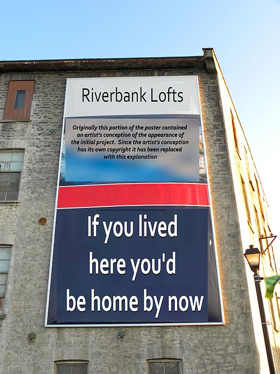
English: The Riverbank lofts Condo, in Downtown Hespeler, Ontario, part of a real estate development operation. The development is right on the
Speed River, and has been compared with Toronto's
Distillery district, a campus of 19th Century industrial buildings transformed into a hip hub of condos, boutiques and restaurants.
To address concerns that the original poster had its copyright, it has been largely reformatted. |
| Date | |
| Source | Downtown Hespeler |
| Author | JasonParis from Toronto, Canada |
| Camera location |
| View this and other nearby images on: OpenStreetMap |
|
|---|
.jpg¶ms=043.432462_N_-080.311303_E_globe:Earth_type:camera_source:Flickr_&language=en)
Licensing
This file is licensed under the
Creative Commons
Attribution 2.0 Generic license.
- You are free:
- to share – to copy, distribute and transmit the work
- to remix – to adapt the work
- Under the following conditions:
- attribution – You must give appropriate credit, provide a link to the license, and indicate if changes were made. You may do so in any reasonable manner, but not in any way that suggests the licensor endorses you or your use.
| This image was originally posted to Flickr by JasonParis at https://www.flickr.com/photos/94064020@N00/6622482049. It was reviewed on 30 September 2014 by FlickreviewR and was confirmed to be licensed under the terms of the cc-by-2.0. |
File history
Click on a date/time to view the file as it appeared at that time.
| Date/Time | Thumbnail | Dimensions | User | Comment | |
|---|---|---|---|---|---|
| current | 13:52, 10 October 2014 |
| 3,000 × 4,000 (1.14 MB) | Geo Swan | Change replacement text |
| 12:50, 10 October 2014 |
 | 3,000 × 4,000 (1.17 MB) | Geo Swan | as per File talk:Downtown Hespeler (6622482049).jpg#Copyright issues. | |
| 12:31, 10 October 2014 |
 | 3,000 × 4,000 (1.12 MB) | Geo Swan | reformat replacement text | |
| 04:55, 30 September 2014 |
 | 3,000 × 4,000 (1.08 MB) | Geo Swan | possible copyvio element corrected | |
| 03:06, 30 September 2014 | No thumbnail | 3,000 × 4,000 (3.44 MB) | Geo Swan | Transferred from Flickr via Flickr2commons |
.jpg&action=edit&redlink=1)
File usage
No pages on the English Wikipedia use this file (pages on other projects are not listed).
Metadata
.jpg)
Size of this preview:
450 × 600 pixels. Other resolutions:
180 × 240 pixels |
360 × 480 pixels |
576 × 768 pixels |
768 × 1,024 pixels |
1,536 × 2,048 pixels |
3,000 × 4,000 pixels.
Original file (3,000 × 4,000 pixels, file size: 1.14 MB, MIME type: image/jpeg)
| This is a file from the
Wikimedia Commons. Information from its
description page there is shown below. Commons is a freely licensed media file repository. You can help. |
Summary
| Description |
English: The Riverbank lofts Condo, in Downtown Hespeler, Ontario, part of a real estate development operation. The development is right on the
Speed River, and has been compared with Toronto's
Distillery district, a campus of 19th Century industrial buildings transformed into a hip hub of condos, boutiques and restaurants.
To address concerns that the original poster had its copyright, it has been largely reformatted. |
| Date | |
| Source | Downtown Hespeler |
| Author | JasonParis from Toronto, Canada |
| Camera location |
| View this and other nearby images on: OpenStreetMap |
|
|---|
Licensing
This file is licensed under the
Creative Commons
Attribution 2.0 Generic license.
- You are free:
- to share – to copy, distribute and transmit the work
- to remix – to adapt the work
- Under the following conditions:
- attribution – You must give appropriate credit, provide a link to the license, and indicate if changes were made. You may do so in any reasonable manner, but not in any way that suggests the licensor endorses you or your use.
| This image was originally posted to Flickr by JasonParis at https://www.flickr.com/photos/94064020@N00/6622482049. It was reviewed on 30 September 2014 by FlickreviewR and was confirmed to be licensed under the terms of the cc-by-2.0. |
File history
Click on a date/time to view the file as it appeared at that time.
| Date/Time | Thumbnail | Dimensions | User | Comment | |
|---|---|---|---|---|---|
| current | 13:52, 10 October 2014 |
| 3,000 × 4,000 (1.14 MB) | Geo Swan | Change replacement text |
| 12:50, 10 October 2014 |
| 3,000 × 4,000 (1.17 MB) | Geo Swan | as per File talk:Downtown Hespeler (6622482049).jpg#Copyright issues. | |
| 12:31, 10 October 2014 |
| 3,000 × 4,000 (1.12 MB) | Geo Swan | reformat replacement text | |
| 04:55, 30 September 2014 |
| 3,000 × 4,000 (1.08 MB) | Geo Swan | possible copyvio element corrected | |
| 03:06, 30 September 2014 | No thumbnail | 3,000 × 4,000 (3.44 MB) | Geo Swan | Transferred from Flickr via Flickr2commons |
File usage
No pages on the English Wikipedia use this file (pages on other projects are not listed).