
Size of this preview:
800 × 580 pixels. Other resolutions:
320 × 232 pixels |
640 × 464 pixels |
1,024 × 742 pixels |
1,280 × 927 pixels |
2,650 × 1,920 pixels.
Original file (2,650 × 1,920 pixels, file size: 1.63 MB, MIME type: image/jpeg)
| This is a file from the
Wikimedia Commons. Information from its
description page there is shown below. Commons is a freely licensed media file repository. You can help. |
Summary
| Description |
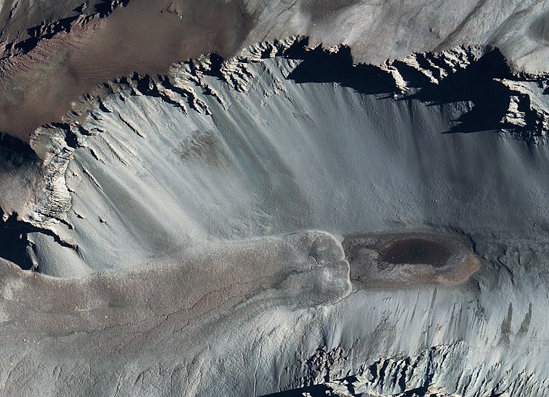
English: Satellite photo of Don Juan Pond
Deutsch: Satellitenfoto des Don-Juan-See |
| Source | Great Zoom into Don Juan Pond, Antarctica (treatment #2) |
| Author | NASA/Goddard Space Flight Center Scientific Visualization Studio, Landsat 7 Project Science Office; MODIS Rapid Response Team, NASA Goddard Space Flight Center ( http://rapidfire.sci.gsfc.nasa.gov) |
Licensing
| This file is in the public domain in the United States because it was solely created by NASA. NASA copyright policy states that "NASA material is not protected by copyright unless noted". (See Template:PD-USGov, NASA copyright policy page or JPL Image Use Policy.) | ||
 |
Warnings:
|
File history
Click on a date/time to view the file as it appeared at that time.
| Date/Time | Thumbnail | Dimensions | User | Comment | |
|---|---|---|---|---|---|
| current | 08:54, 16 November 2017 |
| 2,650 × 1,920 (1.63 MB) | Szczureq | NOW it is in full resolution |
| 17:28, 29 May 2014 |
 | 1,550 × 1,123 (1.81 MB) | Szczureq | full resolution | |
| 15:10, 2 November 2009 |
 | 320 × 231 (15 KB) | Peter in s | {{Information |Description={{en|1=Satellite photo of Don Juan Pond}} {{de|1=Satellitenfoto des Don-Juan-See}} |Source=NASA/Goddard Space Flight Center Scientific Visualization Studio, Landsat 7 Project Science Office; MODIS Rapid Response Team, NASA Godda |
File usage
The following pages on the English Wikipedia use this file (pages on other projects are not listed):
Global file usage
The following other wikis use this file:
- Usage on ar.wikipedia.org
- Usage on az.wikipedia.org
- Usage on bg.wikipedia.org
- Usage on ca.wikipedia.org
- Usage on ceb.wikipedia.org
- Usage on cs.wikipedia.org
- Usage on de.wikipedia.org
- Usage on eo.wikipedia.org
- Usage on es.wikipedia.org
- Usage on fa.wikipedia.org
- Usage on fr.wikipedia.org
- Usage on he.wikipedia.org
- Usage on id.wikipedia.org
- Usage on it.wikipedia.org
- Usage on ja.wikipedia.org
- Usage on ka.wikipedia.org
- Usage on lv.wikipedia.org
- Usage on nl.wikipedia.org
- Usage on nn.wikipedia.org
- Usage on pl.wikipedia.org
- Usage on ru.wikipedia.org
- Usage on sv.wikipedia.org
- Usage on th.wikipedia.org
- Usage on tr.wikipedia.org
- Usage on uk.wikipedia.org
- Usage on vi.wikipedia.org
- Usage on www.wikidata.org
- Usage on zh.wikipedia.org
Size of this preview:
800 × 580 pixels. Other resolutions:
320 × 232 pixels |
640 × 464 pixels |
1,024 × 742 pixels |
1,280 × 927 pixels |
2,650 × 1,920 pixels.
Original file (2,650 × 1,920 pixels, file size: 1.63 MB, MIME type: image/jpeg)
| This is a file from the
Wikimedia Commons. Information from its
description page there is shown below. Commons is a freely licensed media file repository. You can help. |
Summary
| Description |
English: Satellite photo of Don Juan Pond
Deutsch: Satellitenfoto des Don-Juan-See |
| Source | Great Zoom into Don Juan Pond, Antarctica (treatment #2) |
| Author | NASA/Goddard Space Flight Center Scientific Visualization Studio, Landsat 7 Project Science Office; MODIS Rapid Response Team, NASA Goddard Space Flight Center ( http://rapidfire.sci.gsfc.nasa.gov) |
Licensing
| This file is in the public domain in the United States because it was solely created by NASA. NASA copyright policy states that "NASA material is not protected by copyright unless noted". (See Template:PD-USGov, NASA copyright policy page or JPL Image Use Policy.) | ||
|
Warnings:
|
File history
Click on a date/time to view the file as it appeared at that time.
| Date/Time | Thumbnail | Dimensions | User | Comment | |
|---|---|---|---|---|---|
| current | 08:54, 16 November 2017 |
| 2,650 × 1,920 (1.63 MB) | Szczureq | NOW it is in full resolution |
| 17:28, 29 May 2014 |
| 1,550 × 1,123 (1.81 MB) | Szczureq | full resolution | |
| 15:10, 2 November 2009 |
| 320 × 231 (15 KB) | Peter in s | {{Information |Description={{en|1=Satellite photo of Don Juan Pond}} {{de|1=Satellitenfoto des Don-Juan-See}} |Source=NASA/Goddard Space Flight Center Scientific Visualization Studio, Landsat 7 Project Science Office; MODIS Rapid Response Team, NASA Godda |
File usage
The following pages on the English Wikipedia use this file (pages on other projects are not listed):
Global file usage
The following other wikis use this file:
- Usage on ar.wikipedia.org
- Usage on az.wikipedia.org
- Usage on bg.wikipedia.org
- Usage on ca.wikipedia.org
- Usage on ceb.wikipedia.org
- Usage on cs.wikipedia.org
- Usage on de.wikipedia.org
- Usage on eo.wikipedia.org
- Usage on es.wikipedia.org
- Usage on fa.wikipedia.org
- Usage on fr.wikipedia.org
- Usage on he.wikipedia.org
- Usage on id.wikipedia.org
- Usage on it.wikipedia.org
- Usage on ja.wikipedia.org
- Usage on ka.wikipedia.org
- Usage on lv.wikipedia.org
- Usage on nl.wikipedia.org
- Usage on nn.wikipedia.org
- Usage on pl.wikipedia.org
- Usage on ru.wikipedia.org
- Usage on sv.wikipedia.org
- Usage on th.wikipedia.org
- Usage on tr.wikipedia.org
- Usage on uk.wikipedia.org
- Usage on vi.wikipedia.org
- Usage on www.wikidata.org
- Usage on zh.wikipedia.org