Photos • Location


Size of this preview:
800 × 532 pixels. Other resolutions:
320 × 213 pixels |
640 × 426 pixels |
1,024 × 682 pixels |
1,280 × 852 pixels |
2,560 × 1,704 pixels |
4,928 × 3,280 pixels.
Original file (4,928 × 3,280 pixels, file size: 1.6 MB, MIME type: image/jpeg)
| This is a file from the
Wikimedia Commons. Information from its
description page there is shown below. Commons is a freely licensed media file repository. You can help. |
Summary
| Description |
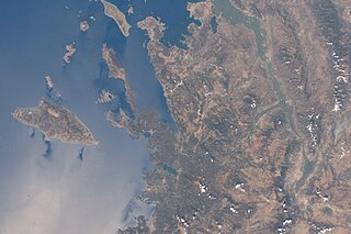
English: Dodecanese and Anatolian coasts in 2016 |
| Date | |
| Source | https://eol.jsc.nasa.gov/SearchPhotos/photo.pl?mission=ISS048&roll=E&frame=63874 |
| Author | NASA |
| Camera location |
| View this and other nearby images on: OpenStreetMap |
|
|---|
Licensing
This file is in the
public domain in the United States because it was created by the Image Science & Analysis Laboratory, of the
NASA Johnson Space Center. NASA copyright policy states that "NASA material is not protected by copyright unless noted". (
NASA media use guidelines or
Conditions of Use of Astronaut Photographs).
Photo source:
ISS048-E-63874.
|
File history
Click on a date/time to view the file as it appeared at that time.
| Date/Time | Thumbnail | Dimensions | User | Comment | |
|---|---|---|---|---|---|
| current | 17:32, 8 February 2021 |
| 4,928 × 3,280 (1.6 MB) | Ahmetlii | Uploaded a work by NASA from https://eol.jsc.nasa.gov/SearchPhotos/photo.pl?mission=ISS048&roll=E&frame=63874 with UploadWizard |
File usage
The following pages on the English Wikipedia use this file (pages on other projects are not listed):
Global file usage
The following other wikis use this file:
- Usage on it.wikipedia.org
Metadata
Size of this preview:
800 × 532 pixels. Other resolutions:
320 × 213 pixels |
640 × 426 pixels |
1,024 × 682 pixels |
1,280 × 852 pixels |
2,560 × 1,704 pixels |
4,928 × 3,280 pixels.
Original file (4,928 × 3,280 pixels, file size: 1.6 MB, MIME type: image/jpeg)
| This is a file from the
Wikimedia Commons. Information from its
description page there is shown below. Commons is a freely licensed media file repository. You can help. |
Summary
| Description |
English: Dodecanese and Anatolian coasts in 2016 |
| Date | |
| Source | https://eol.jsc.nasa.gov/SearchPhotos/photo.pl?mission=ISS048&roll=E&frame=63874 |
| Author | NASA |
| Camera location |
| View this and other nearby images on: OpenStreetMap |
|
|---|
Licensing
This file is in the
public domain in the United States because it was created by the Image Science & Analysis Laboratory, of the
NASA Johnson Space Center. NASA copyright policy states that "NASA material is not protected by copyright unless noted". (
NASA media use guidelines or
Conditions of Use of Astronaut Photographs).
Photo source:
ISS048-E-63874.
|
File history
Click on a date/time to view the file as it appeared at that time.
| Date/Time | Thumbnail | Dimensions | User | Comment | |
|---|---|---|---|---|---|
| current | 17:32, 8 February 2021 |
| 4,928 × 3,280 (1.6 MB) | Ahmetlii | Uploaded a work by NASA from https://eol.jsc.nasa.gov/SearchPhotos/photo.pl?mission=ISS048&roll=E&frame=63874 with UploadWizard |
File usage
The following pages on the English Wikipedia use this file (pages on other projects are not listed):
Global file usage
The following other wikis use this file:
- Usage on it.wikipedia.org