
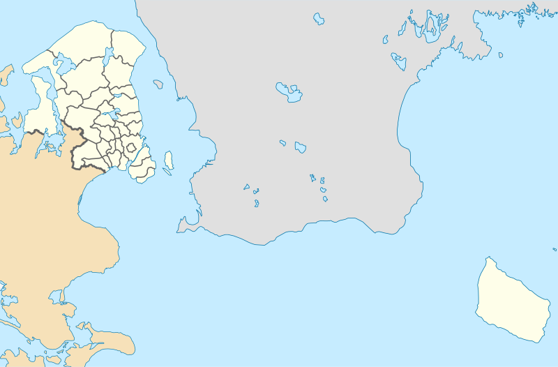
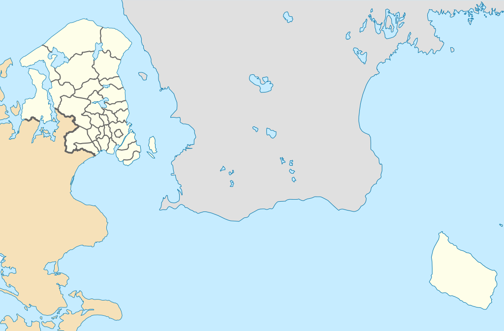
Original file (SVG file, nominally 1,000 × 657 pixels, file size: 244 KB)
| This is a file from the
Wikimedia Commons. Information from its
description page there is shown below. Commons is a freely licensed media file repository. You can help. |
.svg)
Summary
| Description |
English: Location map of the Capital Region in Denmark, color adjusted
Equirectangular projection, N/S stretching 177 %. Geographic limits of the map:
Deutsch: Positionskarte von der Region Hovedstaden in Dänemark, Farben wurden angepasst
Quadratische Plattkarte, N-S-Streckung 177 %. Geographische Begrenzung der Karte:
|
| Date | |
| Source | Own work, derived from Denmark_Capital_Region_location_map.svg |
| Author | Erik Frohne |
| Other versions | Denmark_Capital_Region_location_map.svg |
Licensing

|
Permission is granted to copy, distribute and/or modify this document under the terms of the GNU Free Documentation License, Version 1.2 or any later version published by the Free Software Foundation; with no Invariant Sections, no Front-Cover Texts, and no Back-Cover Texts. A copy of the license is included in the section entitled GNU Free Documentation License. |
- You are free:
- to share – to copy, distribute and transmit the work
- to remix – to adapt the work
- Under the following conditions:
- attribution – You must give appropriate credit, provide a link to the license, and indicate if changes were made. You may do so in any reasonable manner, but not in any way that suggests the licensor endorses you or your use.
- share alike – If you remix, transform, or build upon the material, you must distribute your contributions under the same or compatible license as the original.
File history
Click on a date/time to view the file as it appeared at that time.
| Date/Time | Thumbnail | Dimensions | User | Comment | |
|---|---|---|---|---|---|
| current | 13:37, 13 January 2010 |
| 1,000 × 657 (244 KB) | Erik Frohne | == {{int:filedesc}} == {{Information |Description={{en|1=Location map of the Capital Region in Denmark, color adjusted Equirectangular projection, N/S stretching 177 %. Geographic limits of the map: * N: 56.20° N * S: 54.90° N * W: 11.70° E * E: 15.2 |
File usage
More than 100 pages use this file. The following list shows the first 100 pages that use this file only. A full list is available.
.svg)
- 2015 European Ladies' Team Championship
- Albertslund railway station
- Allerød railway station
- Annisse
- Annisse Nord
- Birkerød
- Blistrup
- Blovstrød
- Bondebyen
- Brede, Denmark
- Charlottenlund railway station
- Copenhagen Airport
- Copenhagen South railway station
- Dragør
- Egedal railway station
- Esbønderup
- Farum
- Farum railway station
- Favrholm railway station
- Fortunen
- Fredensborg
- Frederikssund
- Frederiksværk
- Frederiksværk railway station
- Fuglevad
- Ganløse
- Gerlev
- Gilleleje
- Glostrup railway station
- Græse Bakkeby
- Græsted
- Græsted South railway halt
- Græsted railway station
- Hedehusene
- Hedehusene railway station
- Hellebæk
- Helsinge
- Helsinge railway station
- Helsingør
- Hillerød
- Hillerød railway station
- Hjortekær
- Humlebæk
- Humlebæk railway station
- Hundested
- Høje Taastrup railway station
- Jægersborg railway station
- Jægerspris
- Kagerup
- Kagerup railway station
- Klampenborg station
- Kokkedal railway station
- Kongens Lyngby
- Kulhuse
- Kvistgård
- Lillerød
- Liseleje
- Lundtofte
- Lyngby railway station
- Lynge, Allerød Municipality
- Melby, Halsnæs Municipality
- Måløv railway station
- Mårum
- Nivå
- Nivå railway station
- Nødebo
- Nørre Herlev
- Ordrup railway station
- Pårup railway halt
- Raadvad
- Ramløse
- Ravnholm
- Reerslev
- Rungsted Kyst railway station
- Rågeleje
- Saltrup railway halt
- Sengeløse
- Skibby
- Skodsborg
- Skodsborg railway station
- Skuldelev
- Skævinge
- Slangerup
- Smidstrup
- Sorgenfri
- Spring-forbi
- Stenløse railway station
- Taarbæk
- Tisvilde
- Tisvildeleje railway station
- Torup, Halsnæs Municipality
- Vallensbæk
- Vallensbæk Landsby
- Vedbæk railway station
- Vejby, Gribskov Municipality
- Virum
- Værløse
- Ølsted, Halsnæs Municipality
- Ølstykke-Stenløse
- Ølstykke railway station
View more links to this file.
Global file usage
The following other wikis use this file:
- Usage on bn.wikipedia.org
- Usage on da.wikipedia.org
- Frederiksberg
- Middelgrundsfortet
- Nivå
- Kronborg
- Indre By (København)
- Valby
- Vanløse
- Brønshøj-Husum
- Bispebjerg
- Sundbyøster
- Sundbyvester
- Hesselø
- Peberholm
- Louisiana (kunstmuseum)
- Vallensbæk
- Helsingør
- Charlottenlund
- Hillerød
- Slangerup
- Vangede
- Smørum
- Værløse
- Ørestad
- Hellerup
- Helsinge
- Gilleleje
- Holte
- Dragør
- Birkerød Gymnasium, HF, IB & Kostskole
- Buresø
- Østerbro
- Dyssegård
- Birkerød
- Kongens Lyngby
- Høje-Taastrup
- Taastrup
- Hedehusene
- Hvidovre
- Christiansø
- Frederikssund
- Fredensborg
- Jægerspris
- Gentofte
- Hvissinge
- Ejby (Glostrup)
- Nørrebro
- Græsholm (Ertholmene)
- Glostrup
- Hellebæk
View more global usage of this file.
.svg)
.svg)
Original file (SVG file, nominally 1,000 × 657 pixels, file size: 244 KB)
| This is a file from the
Wikimedia Commons. Information from its
description page there is shown below. Commons is a freely licensed media file repository. You can help. |
Summary
| Description |
English: Location map of the Capital Region in Denmark, color adjusted
Equirectangular projection, N/S stretching 177 %. Geographic limits of the map:
Deutsch: Positionskarte von der Region Hovedstaden in Dänemark, Farben wurden angepasst
Quadratische Plattkarte, N-S-Streckung 177 %. Geographische Begrenzung der Karte:
|
| Date | |
| Source | Own work, derived from Denmark_Capital_Region_location_map.svg |
| Author | Erik Frohne |
| Other versions | Denmark_Capital_Region_location_map.svg |
Licensing
|
|
Permission is granted to copy, distribute and/or modify this document under the terms of the GNU Free Documentation License, Version 1.2 or any later version published by the Free Software Foundation; with no Invariant Sections, no Front-Cover Texts, and no Back-Cover Texts. A copy of the license is included in the section entitled GNU Free Documentation License. |
- You are free:
- to share – to copy, distribute and transmit the work
- to remix – to adapt the work
- Under the following conditions:
- attribution – You must give appropriate credit, provide a link to the license, and indicate if changes were made. You may do so in any reasonable manner, but not in any way that suggests the licensor endorses you or your use.
- share alike – If you remix, transform, or build upon the material, you must distribute your contributions under the same or compatible license as the original.
File history
Click on a date/time to view the file as it appeared at that time.
| Date/Time | Thumbnail | Dimensions | User | Comment | |
|---|---|---|---|---|---|
| current | 13:37, 13 January 2010 |
| 1,000 × 657 (244 KB) | Erik Frohne | == {{int:filedesc}} == {{Information |Description={{en|1=Location map of the Capital Region in Denmark, color adjusted Equirectangular projection, N/S stretching 177 %. Geographic limits of the map: * N: 56.20° N * S: 54.90° N * W: 11.70° E * E: 15.2 |
File usage
More than 100 pages use this file. The following list shows the first 100 pages that use this file only. A full list is available.
- 2015 European Ladies' Team Championship
- Albertslund railway station
- Allerød railway station
- Annisse
- Annisse Nord
- Birkerød
- Blistrup
- Blovstrød
- Bondebyen
- Brede, Denmark
- Charlottenlund railway station
- Copenhagen Airport
- Copenhagen South railway station
- Dragør
- Egedal railway station
- Esbønderup
- Farum
- Farum railway station
- Favrholm railway station
- Fortunen
- Fredensborg
- Frederikssund
- Frederiksværk
- Frederiksværk railway station
- Fuglevad
- Ganløse
- Gerlev
- Gilleleje
- Glostrup railway station
- Græse Bakkeby
- Græsted
- Græsted South railway halt
- Græsted railway station
- Hedehusene
- Hedehusene railway station
- Hellebæk
- Helsinge
- Helsinge railway station
- Helsingør
- Hillerød
- Hillerød railway station
- Hjortekær
- Humlebæk
- Humlebæk railway station
- Hundested
- Høje Taastrup railway station
- Jægersborg railway station
- Jægerspris
- Kagerup
- Kagerup railway station
- Klampenborg station
- Kokkedal railway station
- Kongens Lyngby
- Kulhuse
- Kvistgård
- Lillerød
- Liseleje
- Lundtofte
- Lyngby railway station
- Lynge, Allerød Municipality
- Melby, Halsnæs Municipality
- Måløv railway station
- Mårum
- Nivå
- Nivå railway station
- Nødebo
- Nørre Herlev
- Ordrup railway station
- Pårup railway halt
- Raadvad
- Ramløse
- Ravnholm
- Reerslev
- Rungsted Kyst railway station
- Rågeleje
- Saltrup railway halt
- Sengeløse
- Skibby
- Skodsborg
- Skodsborg railway station
- Skuldelev
- Skævinge
- Slangerup
- Smidstrup
- Sorgenfri
- Spring-forbi
- Stenløse railway station
- Taarbæk
- Tisvilde
- Tisvildeleje railway station
- Torup, Halsnæs Municipality
- Vallensbæk
- Vallensbæk Landsby
- Vedbæk railway station
- Vejby, Gribskov Municipality
- Virum
- Værløse
- Ølsted, Halsnæs Municipality
- Ølstykke-Stenløse
- Ølstykke railway station
View more links to this file.
Global file usage
The following other wikis use this file:
- Usage on bn.wikipedia.org
- Usage on da.wikipedia.org
- Frederiksberg
- Middelgrundsfortet
- Nivå
- Kronborg
- Indre By (København)
- Valby
- Vanløse
- Brønshøj-Husum
- Bispebjerg
- Sundbyøster
- Sundbyvester
- Hesselø
- Peberholm
- Louisiana (kunstmuseum)
- Vallensbæk
- Helsingør
- Charlottenlund
- Hillerød
- Slangerup
- Vangede
- Smørum
- Værløse
- Ørestad
- Hellerup
- Helsinge
- Gilleleje
- Holte
- Dragør
- Birkerød Gymnasium, HF, IB & Kostskole
- Buresø
- Østerbro
- Dyssegård
- Birkerød
- Kongens Lyngby
- Høje-Taastrup
- Taastrup
- Hedehusene
- Hvidovre
- Christiansø
- Frederikssund
- Fredensborg
- Jægerspris
- Gentofte
- Hvissinge
- Ejby (Glostrup)
- Nørrebro
- Græsholm (Ertholmene)
- Glostrup
- Hellebæk
View more global usage of this file.