No higher resolution available.
Dendera_Topo_Map.jpg (563 × 400 pixels, file size: 95 KB, MIME type: image/jpeg)
| This is a file from the
Wikimedia Commons. Information from its
description page there is shown below. Commons is a freely licensed media file repository. You can help. |
Summary
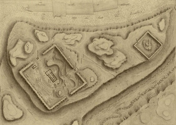
| Description |
English: Denderah (Tentyris), topographical map of the ruins Français : Denderah (Tentyris), plan topographique des ruines |
| Date | |
| Source | Description de l'Egypte, Plate Volume Antiquités IV, Plate 2 |
| Author | Napoleon Expedition |
Licensing
|
This work is in the public domain in its country of origin and other countries and areas where the copyright term is the author's life plus 100 years or fewer. | |
| This file has been identified as being free of known restrictions under copyright law, including all related and neighboring rights. | |
File history
Click on a date/time to view the file as it appeared at that time.
| Date/Time | Thumbnail | Dimensions | User | Comment | |
|---|---|---|---|---|---|
| current | 08:13, 13 April 2011 |
| 563 × 400 (95 KB) | Sinuhe20 | {{Information |Description ={{fr|1=Denderah (Tentyris), plan topographique des ruines}} |Source =[http://descegy.bibalex.org/ Description de l'Egypte, Plate Volume Antiquités IV, Plate 2] |Author =Napoleon Expedition |Date =1 |
File usage
The following pages on the English Wikipedia use this file (pages on other projects are not listed):
Global file usage
The following other wikis use this file:
- Usage on ar.wikipedia.org
- Usage on bn.wikipedia.org
- Usage on de.wikipedia.org
- Usage on el.wikipedia.org
- Usage on fr.wikipedia.org
- Usage on ms.wikipedia.org
- Usage on sl.wikipedia.org
- Usage on sw.wikipedia.org
- Usage on uk.wikipedia.org
- Usage on ur.wikipedia.org
Metadata
No higher resolution available.
Dendera_Topo_Map.jpg (563 × 400 pixels, file size: 95 KB, MIME type: image/jpeg)
| This is a file from the
Wikimedia Commons. Information from its
description page there is shown below. Commons is a freely licensed media file repository. You can help. |
Summary
| Description |
English: Denderah (Tentyris), topographical map of the ruins Français : Denderah (Tentyris), plan topographique des ruines |
| Date | |
| Source | Description de l'Egypte, Plate Volume Antiquités IV, Plate 2 |
| Author | Napoleon Expedition |
Licensing
|
This work is in the public domain in its country of origin and other countries and areas where the copyright term is the author's life plus 100 years or fewer. | |
| This file has been identified as being free of known restrictions under copyright law, including all related and neighboring rights. | |
File history
Click on a date/time to view the file as it appeared at that time.
| Date/Time | Thumbnail | Dimensions | User | Comment | |
|---|---|---|---|---|---|
| current | 08:13, 13 April 2011 |
| 563 × 400 (95 KB) | Sinuhe20 | {{Information |Description ={{fr|1=Denderah (Tentyris), plan topographique des ruines}} |Source =[http://descegy.bibalex.org/ Description de l'Egypte, Plate Volume Antiquités IV, Plate 2] |Author =Napoleon Expedition |Date =1 |
File usage
The following pages on the English Wikipedia use this file (pages on other projects are not listed):
Global file usage
The following other wikis use this file:
- Usage on ar.wikipedia.org
- Usage on bn.wikipedia.org
- Usage on de.wikipedia.org
- Usage on el.wikipedia.org
- Usage on fr.wikipedia.org
- Usage on ms.wikipedia.org
- Usage on sl.wikipedia.org
- Usage on sw.wikipedia.org
- Usage on uk.wikipedia.org
- Usage on ur.wikipedia.org