Photos • Location


Size of this preview:
800 × 486 pixels. Other resolutions:
320 × 194 pixels |
640 × 389 pixels |
1,024 × 622 pixels |
1,280 × 777 pixels |
2,560 × 1,554 pixels |
5,619 × 3,411 pixels.
Original file (5,619 × 3,411 pixels, file size: 14.71 MB, MIME type: image/jpeg)
| This is a file from the
Wikimedia Commons. Information from its
description page there is shown below. Commons is a freely licensed media file repository. You can help. |
Summary
| Description |
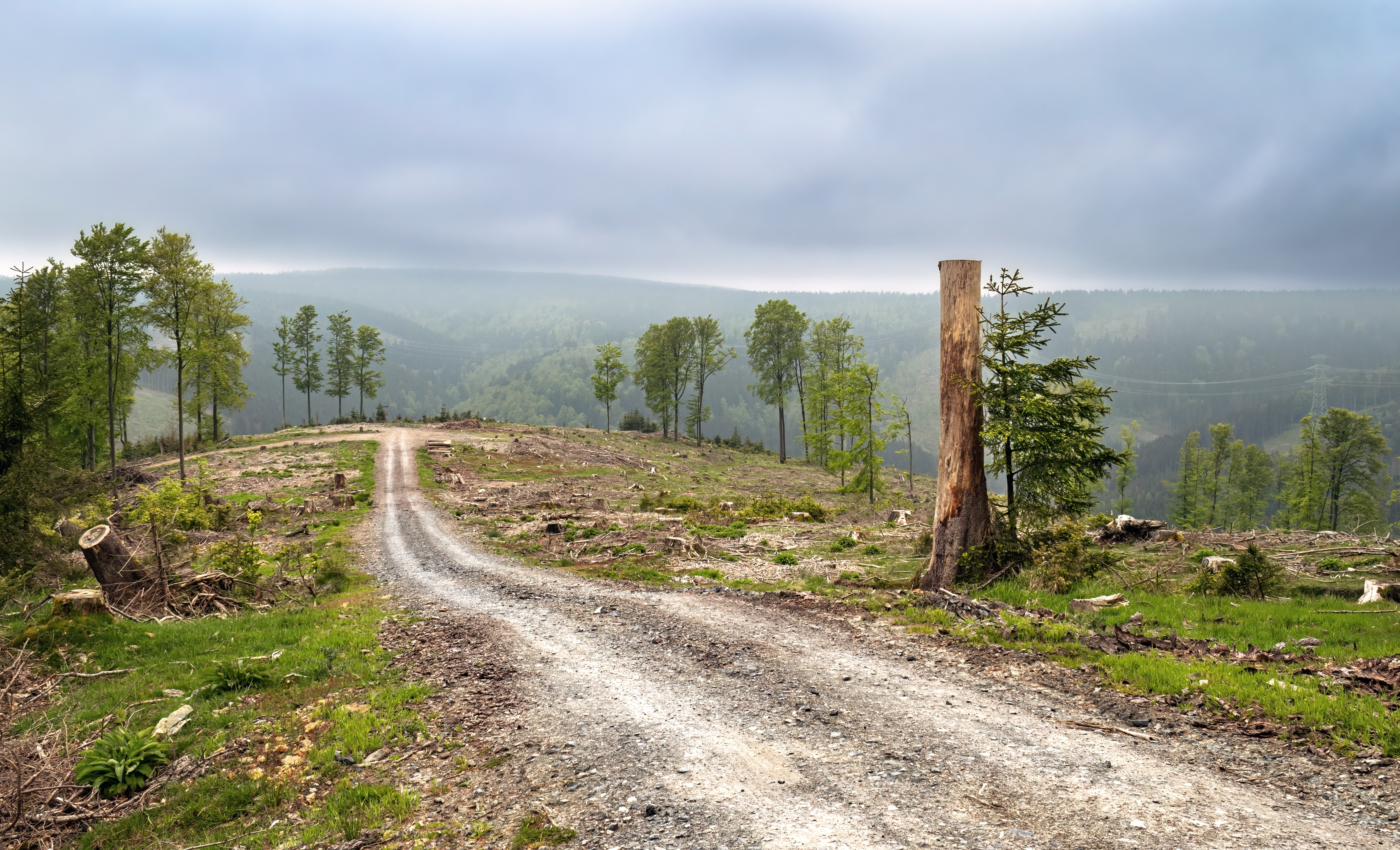
English: Deforested area 170 meters above the
Goldisthal lower reservoir, part of Germany's largest pumped-storage
power plant.
Deutsch: Abgeholzte Waldfläche 170 Meter oberhalb des Unterbeckens
Goldisthal, das zum größten
Pumpspeicherwerk Deutschlands gehört.
Polski: Wylesiony obszar 170 metrów nad dolnym zbiornikiem
Goldisthal, częścią największej niemieckiej
elektrowni szczytowo-pompowej. |
| Date | Taken on 20 May 2023, 10:42:39 |
| Source | Own work |
| Author | Radomianin |
| Camera location | | View this and other nearby images on: OpenStreetMap |
|
|---|
| Attribution ( required by the license) | © Radomianin / Wikimedia Commons / CC BY-SA 4.0 |
| Using this image | You can use this image file free of charge under the terms of the free license
CC BY-SA 4.0. In particular, this means:
|
| Editing this image |
|
Assessment
This image has been assessed using the
Quality image guidelines and is considered a
Quality image.
|
Licensing
I, the copyright holder of this work, hereby publish it under the following license:
This file is licensed under the
Creative Commons
Attribution-Share Alike 4.0 International license.
- You are free:
- to share – to copy, distribute and transmit the work
- to remix – to adapt the work
- Under the following conditions:
- attribution – You must give appropriate credit, provide a link to the license, and indicate if changes were made. You may do so in any reasonable manner, but not in any way that suggests the licensor endorses you or your use.
- share alike – If you remix, transform, or build upon the material, you must distribute your contributions under the same or compatible license as the original.
File history
Click on a date/time to view the file as it appeared at that time.
| Date/Time | Thumbnail | Dimensions | User | Comment | |
|---|---|---|---|---|---|
| current | 08:00, 20 February 2024 |
| 5,619 × 3,411 (14.71 MB) | Radomianin | Improved saturation values |
| 22:00, 18 February 2024 |
 | 5,619 × 3,411 (14.84 MB) | Radomianin | Metadata updated | |
| 21:00, 18 February 2024 |
 | 5,619 × 3,411 (14.84 MB) | Radomianin | Uploaded own work with UploadWizard |
File usage
The following pages on the English Wikipedia use this file (pages on other projects are not listed):
Metadata
Size of this preview:
800 × 486 pixels. Other resolutions:
320 × 194 pixels |
640 × 389 pixels |
1,024 × 622 pixels |
1,280 × 777 pixels |
2,560 × 1,554 pixels |
5,619 × 3,411 pixels.
Original file (5,619 × 3,411 pixels, file size: 14.71 MB, MIME type: image/jpeg)
| This is a file from the
Wikimedia Commons. Information from its
description page there is shown below. Commons is a freely licensed media file repository. You can help. |
Summary
| Description |
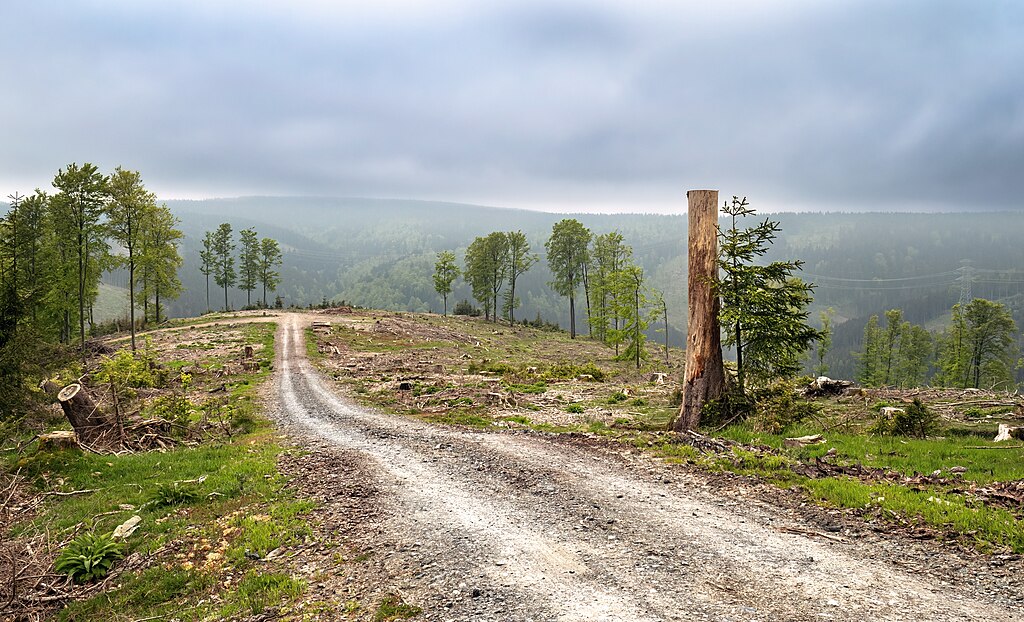
English: Deforested area 170 meters above the
Goldisthal lower reservoir, part of Germany's largest pumped-storage
power plant.
Deutsch: Abgeholzte Waldfläche 170 Meter oberhalb des Unterbeckens
Goldisthal, das zum größten
Pumpspeicherwerk Deutschlands gehört.
Polski: Wylesiony obszar 170 metrów nad dolnym zbiornikiem
Goldisthal, częścią największej niemieckiej
elektrowni szczytowo-pompowej. |
| Date | Taken on 20 May 2023, 10:42:39 |
| Source | Own work |
| Author | Radomianin |
| Camera location | | View this and other nearby images on: OpenStreetMap |
|
|---|
| Attribution ( required by the license) | © Radomianin / Wikimedia Commons / CC BY-SA 4.0 |
| Using this image | You can use this image file free of charge under the terms of the free license
CC BY-SA 4.0. In particular, this means:
|
| Editing this image |
|
Assessment
This image has been assessed using the
Quality image guidelines and is considered a
Quality image.
|
Licensing
I, the copyright holder of this work, hereby publish it under the following license:
This file is licensed under the
Creative Commons
Attribution-Share Alike 4.0 International license.
- You are free:
- to share – to copy, distribute and transmit the work
- to remix – to adapt the work
- Under the following conditions:
- attribution – You must give appropriate credit, provide a link to the license, and indicate if changes were made. You may do so in any reasonable manner, but not in any way that suggests the licensor endorses you or your use.
- share alike – If you remix, transform, or build upon the material, you must distribute your contributions under the same or compatible license as the original.
File history
Click on a date/time to view the file as it appeared at that time.
| Date/Time | Thumbnail | Dimensions | User | Comment | |
|---|---|---|---|---|---|
| current | 08:00, 20 February 2024 |
| 5,619 × 3,411 (14.71 MB) | Radomianin | Improved saturation values |
| 22:00, 18 February 2024 |
| 5,619 × 3,411 (14.84 MB) | Radomianin | Metadata updated | |
| 21:00, 18 February 2024 |
| 5,619 × 3,411 (14.84 MB) | Radomianin | Uploaded own work with UploadWizard |
File usage
The following pages on the English Wikipedia use this file (pages on other projects are not listed):