Photos • Location


No higher resolution available.
De_Hoop,_Oudtshoorn.jpg (640 × 427 pixels, file size: 28 KB, MIME type: image/jpeg)
| This is a file from the
Wikimedia Commons. Information from its
description page there is shown below. Commons is a freely licensed media file repository. You can help. |
Summary
| Camera location |
| View this and other nearby images on: OpenStreetMap |
|
|---|
| Description |
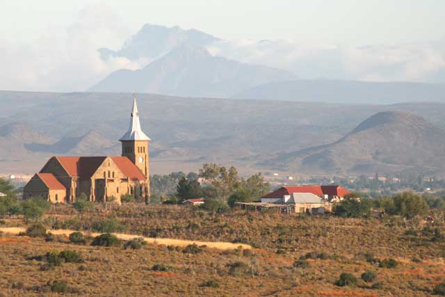
Afrikaans: Kerkgebou van De Hoop-gemeente, 16 km wes van Oudtshoorn, Wes-Kaap. In die agtergrond die Swartrug en Wakloof, en die Camferskloofberg en Cradocksberg (1,579m) van die Outeniekwareeks.
English: Church building of De Hoop congregation, 10 miles west of Oudtshoorn, Western Cape |
| Date | circa 2008 |
| Source | Own work |
| Author | Reinderd Visser, who releases it under the terms below. JMK ( talk) 13:26, 15 June 2011 (UTC) |
Licensing
This file is licensed under the
Creative Commons
Attribution-Share Alike 3.0 Unported license.
- You are free:
- to share – to copy, distribute and transmit the work
- to remix – to adapt the work
- Under the following conditions:
- attribution – You must give appropriate credit, provide a link to the license, and indicate if changes were made. You may do so in any reasonable manner, but not in any way that suggests the licensor endorses you or your use.
- share alike – If you remix, transform, or build upon the material, you must distribute your contributions under the same or compatible license as the original.
File history
Click on a date/time to view the file as it appeared at that time.
| Date/Time | Thumbnail | Dimensions | User | Comment | |
|---|---|---|---|---|---|
| current | 13:26, 15 June 2011 |
| 640 × 427 (28 KB) | JMK | {{Information |Description ={{af|1=Kerkgebou van De Hoop-gemeente, Oudtshoorn, Weskaap}} {{en|1=Church building of De Hoop congregation, Oudtshoorn, Western Cape}} |Source ={{own}} |Author =Reinderd Visser, who releases it under the ter |
File usage
The following pages on the English Wikipedia use this file (pages on other projects are not listed):
Global file usage
The following other wikis use this file:
- Usage on af.wikipedia.org
- Usage on ceb.wikipedia.org
- Usage on en.wikivoyage.org
- Usage on et.wikipedia.org
- Usage on fr.wikipedia.org
- Usage on it.wikipedia.org
- Usage on pl.wikipedia.org
- Usage on www.wikidata.org
- Usage on yo.wikipedia.org
- Usage on zu.wikipedia.org
Metadata
No higher resolution available.
De_Hoop,_Oudtshoorn.jpg (640 × 427 pixels, file size: 28 KB, MIME type: image/jpeg)
| This is a file from the
Wikimedia Commons. Information from its
description page there is shown below. Commons is a freely licensed media file repository. You can help. |
Summary
| Camera location |
| View this and other nearby images on: OpenStreetMap |
|
|---|
| Description |
Afrikaans: Kerkgebou van De Hoop-gemeente, 16 km wes van Oudtshoorn, Wes-Kaap. In die agtergrond die Swartrug en Wakloof, en die Camferskloofberg en Cradocksberg (1,579m) van die Outeniekwareeks.
English: Church building of De Hoop congregation, 10 miles west of Oudtshoorn, Western Cape |
| Date | circa 2008 |
| Source | Own work |
| Author | Reinderd Visser, who releases it under the terms below. JMK ( talk) 13:26, 15 June 2011 (UTC) |
Licensing
This file is licensed under the
Creative Commons
Attribution-Share Alike 3.0 Unported license.
- You are free:
- to share – to copy, distribute and transmit the work
- to remix – to adapt the work
- Under the following conditions:
- attribution – You must give appropriate credit, provide a link to the license, and indicate if changes were made. You may do so in any reasonable manner, but not in any way that suggests the licensor endorses you or your use.
- share alike – If you remix, transform, or build upon the material, you must distribute your contributions under the same or compatible license as the original.
File history
Click on a date/time to view the file as it appeared at that time.
| Date/Time | Thumbnail | Dimensions | User | Comment | |
|---|---|---|---|---|---|
| current | 13:26, 15 June 2011 |
| 640 × 427 (28 KB) | JMK | {{Information |Description ={{af|1=Kerkgebou van De Hoop-gemeente, Oudtshoorn, Weskaap}} {{en|1=Church building of De Hoop congregation, Oudtshoorn, Western Cape}} |Source ={{own}} |Author =Reinderd Visser, who releases it under the ter |
File usage
The following pages on the English Wikipedia use this file (pages on other projects are not listed):
Global file usage
The following other wikis use this file:
- Usage on af.wikipedia.org
- Usage on ceb.wikipedia.org
- Usage on en.wikivoyage.org
- Usage on et.wikipedia.org
- Usage on fr.wikipedia.org
- Usage on it.wikipedia.org
- Usage on pl.wikipedia.org
- Usage on www.wikidata.org
- Usage on yo.wikipedia.org
- Usage on zu.wikipedia.org