Photos • Location


Size of this preview:
450 × 600 pixels. Other resolutions:
180 × 240 pixels |
360 × 480 pixels |
576 × 768 pixels |
768 × 1,024 pixels |
2,448 × 3,264 pixels.
Original file (2,448 × 3,264 pixels, file size: 2.53 MB, MIME type: image/jpeg)
| This is a file from the
Wikimedia Commons. Information from its
description page there is shown below. Commons is a freely licensed media file repository. You can help. |
Summary
| Description |
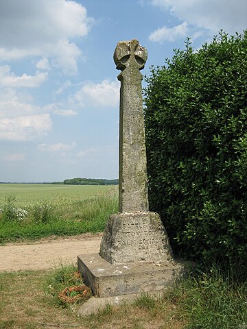
English: Dacre's Cross, near Towton, North Yorkshire. Commemorating the Battle of Towton, Palm Sunday 1461, and the death of Lord Dacre. Probably a parish boundary stone which has been inscribed. |
| Date | |
| Source | Own work |
| Author | Chemical Engineer |
| Camera location |
| View this and other nearby images on: OpenStreetMap |
|
|---|
Licensing
| I, the copyright holder of this work, release this work into the
public domain. This applies worldwide. In some countries this may not be legally possible; if so: I grant anyone the right to use this work for any purpose, without any conditions, unless such conditions are required by law. |
File history
Click on a date/time to view the file as it appeared at that time.
| Date/Time | Thumbnail | Dimensions | User | Comment | |
|---|---|---|---|---|---|
| current | 19:59, 27 June 2010 |
| 2,448 × 3,264 (2.53 MB) | Chemical Engineer | {{Information |Description={{en|1=Dacre's Cross, near Towton, North Yorkshire. Commemorating the Battle of Towton, Palm Sunday 1461, and the death of Lord Dacre. Probably a parish boundary stone which has been inscribed.}} |Source={{own}} |Author=[[User |
File usage
The following pages on the English Wikipedia use this file (pages on other projects are not listed):
Global file usage
The following other wikis use this file:
- Usage on da.wikipedia.org
- Usage on fa.wikipedia.org
- Usage on fr.wikipedia.org
- Usage on pt.wikipedia.org
- Usage on ro.wikipedia.org
- Usage on ru.wikipedia.org
- Usage on www.wikidata.org
- Usage on zh.wikipedia.org
Metadata
Size of this preview:
450 × 600 pixels. Other resolutions:
180 × 240 pixels |
360 × 480 pixels |
576 × 768 pixels |
768 × 1,024 pixels |
2,448 × 3,264 pixels.
Original file (2,448 × 3,264 pixels, file size: 2.53 MB, MIME type: image/jpeg)
| This is a file from the
Wikimedia Commons. Information from its
description page there is shown below. Commons is a freely licensed media file repository. You can help. |
Summary
| Description |
English: Dacre's Cross, near Towton, North Yorkshire. Commemorating the Battle of Towton, Palm Sunday 1461, and the death of Lord Dacre. Probably a parish boundary stone which has been inscribed. |
| Date | |
| Source | Own work |
| Author | Chemical Engineer |
| Camera location |
| View this and other nearby images on: OpenStreetMap |
|
|---|
Licensing
| I, the copyright holder of this work, release this work into the
public domain. This applies worldwide. In some countries this may not be legally possible; if so: I grant anyone the right to use this work for any purpose, without any conditions, unless such conditions are required by law. |
File history
Click on a date/time to view the file as it appeared at that time.
| Date/Time | Thumbnail | Dimensions | User | Comment | |
|---|---|---|---|---|---|
| current | 19:59, 27 June 2010 |
| 2,448 × 3,264 (2.53 MB) | Chemical Engineer | {{Information |Description={{en|1=Dacre's Cross, near Towton, North Yorkshire. Commemorating the Battle of Towton, Palm Sunday 1461, and the death of Lord Dacre. Probably a parish boundary stone which has been inscribed.}} |Source={{own}} |Author=[[User |
File usage
The following pages on the English Wikipedia use this file (pages on other projects are not listed):
Global file usage
The following other wikis use this file:
- Usage on da.wikipedia.org
- Usage on fa.wikipedia.org
- Usage on fr.wikipedia.org
- Usage on pt.wikipedia.org
- Usage on ro.wikipedia.org
- Usage on ru.wikipedia.org
- Usage on www.wikidata.org
- Usage on zh.wikipedia.org