
Size of this PNG preview of this SVG file:
800 × 539 pixels. Other resolutions:
320 × 215 pixels |
640 × 431 pixels |
1,024 × 689 pixels |
1,280 × 862 pixels |
2,560 × 1,724 pixels |
2,020 × 1,360 pixels.
Original file (SVG file, nominally 2,020 × 1,360 pixels, file size: 3.29 MB)
| This is a file from the
Wikimedia Commons. Information from its
description page there is shown below. Commons is a freely licensed media file repository. You can help. |
Summary
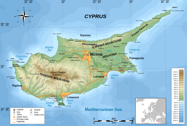
| Description | A topographical map of Cyprus, with zones and optional layers for adaptations |
| Date | 12-02-2020 |
| Source | Cyprus-topographic map-en.svg |
| Author |
|
| Permission ( Reusing this file) |
I, the copyright holder of this work, hereby publish it under the following license: This file is licensed under the
Creative Commons
Attribution-Share Alike 3.0 Unported license.
|
| Other versions | Cyprus map topographic 2.svg |
File history
Click on a date/time to view the file as it appeared at that time.
| Date/Time | Thumbnail | Dimensions | User | Comment | |
|---|---|---|---|---|---|
| current | 22:25, 12 February 2020 |
| 2,020 × 1,360 (3.29 MB) | Hogweard | {{Information |description=A topographical map of Cyprus, with zones and optional layers for adaptations |date=12-02-2020 |source={{f|Cyprus-topographic map-en.svg}} |author=*{{f|Cyprus-topographic map-en.svg}}: {{u|Ikonact}} *Derivative work: {{u|Hogweard}} |permission={{self|cc-by-sa-3.0}} |other versions= }} Category:Topographic maps of Cyprus Category:SVG maps of Cyprus |
File usage
The following pages on the English Wikipedia use this file (pages on other projects are not listed):
Global file usage
The following other wikis use this file:
- Usage on eo.wikipedia.org
- Usage on eu.wikipedia.org
- Usage on sl.wikipedia.org
- Usage on uk.wikipedia.org
- Usage on www.wikidata.org
Metadata
Size of this PNG preview of this SVG file:
800 × 539 pixels. Other resolutions:
320 × 215 pixels |
640 × 431 pixels |
1,024 × 689 pixels |
1,280 × 862 pixels |
2,560 × 1,724 pixels |
2,020 × 1,360 pixels.
Original file (SVG file, nominally 2,020 × 1,360 pixels, file size: 3.29 MB)
| This is a file from the
Wikimedia Commons. Information from its
description page there is shown below. Commons is a freely licensed media file repository. You can help. |
Summary
| Description | A topographical map of Cyprus, with zones and optional layers for adaptations |
| Date | 12-02-2020 |
| Source | Cyprus-topographic map-en.svg |
| Author |
|
| Permission ( Reusing this file) |
I, the copyright holder of this work, hereby publish it under the following license: This file is licensed under the
Creative Commons
Attribution-Share Alike 3.0 Unported license.
|
| Other versions | Cyprus map topographic 2.svg |
File history
Click on a date/time to view the file as it appeared at that time.
| Date/Time | Thumbnail | Dimensions | User | Comment | |
|---|---|---|---|---|---|
| current | 22:25, 12 February 2020 |
| 2,020 × 1,360 (3.29 MB) | Hogweard | {{Information |description=A topographical map of Cyprus, with zones and optional layers for adaptations |date=12-02-2020 |source={{f|Cyprus-topographic map-en.svg}} |author=*{{f|Cyprus-topographic map-en.svg}}: {{u|Ikonact}} *Derivative work: {{u|Hogweard}} |permission={{self|cc-by-sa-3.0}} |other versions= }} Category:Topographic maps of Cyprus Category:SVG maps of Cyprus |
File usage
The following pages on the English Wikipedia use this file (pages on other projects are not listed):
Global file usage
The following other wikis use this file:
- Usage on eo.wikipedia.org
- Usage on eu.wikipedia.org
- Usage on sl.wikipedia.org
- Usage on uk.wikipedia.org
- Usage on www.wikidata.org