Photos • Location


Size of this preview:
800 × 600 pixels. Other resolutions:
320 × 240 pixels |
640 × 480 pixels |
1,024 × 768 pixels |
1,280 × 960 pixels |
2,272 × 1,704 pixels.
Original file (2,272 × 1,704 pixels, file size: 1.36 MB, MIME type: image/jpeg)
| This is a file from the
Wikimedia Commons. Information from its
description page there is shown below. Commons is a freely licensed media file repository. You can help. |
Summary
| Description |
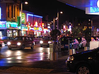
A picture of Rusholme's 'Curry Mile' at night time English: Photograph of the 'Curry Mile' at nighttime |
| Date | early 2005 |
| Source | Self-photographed |
| Author | Pete Morris |
| Permission ( Reusing this file) |
Public Domain photo |
| Camera location | | View this and other nearby images on: OpenStreetMap |
|
|---|
Licensing
| I, the copyright holder of this work, release this work into the
public domain. This applies worldwide. In some countries this may not be legally possible; if so: I grant anyone the right to use this work for any purpose, without any conditions, unless such conditions are required by law. |
File history
Click on a date/time to view the file as it appeared at that time.
| Date/Time | Thumbnail | Dimensions | User | Comment | |
|---|---|---|---|---|---|
| current | 15:32, 12 April 2005 |
| 2,272 × 1,704 (1.36 MB) | Petemorris~commonswiki | {{Information| |Description = A picture of Rusholme's 'Curry Mile' at night time |Source = self-photographed |Date = created sometime early 2005 |Author = Pete Morris |Permission = Public Domain photo }} {{PD}} |
File usage
The following pages on the English Wikipedia use this file (pages on other projects are not listed):
Global file usage
The following other wikis use this file:
- Usage on de.wikipedia.org
- Usage on zh.wikipedia.org
Metadata
Size of this preview:
800 × 600 pixels. Other resolutions:
320 × 240 pixels |
640 × 480 pixels |
1,024 × 768 pixels |
1,280 × 960 pixels |
2,272 × 1,704 pixels.
Original file (2,272 × 1,704 pixels, file size: 1.36 MB, MIME type: image/jpeg)
| This is a file from the
Wikimedia Commons. Information from its
description page there is shown below. Commons is a freely licensed media file repository. You can help. |
Summary
| Description |
A picture of Rusholme's 'Curry Mile' at night time English: Photograph of the 'Curry Mile' at nighttime |
| Date | early 2005 |
| Source | Self-photographed |
| Author | Pete Morris |
| Permission ( Reusing this file) |
Public Domain photo |
| Camera location | | View this and other nearby images on: OpenStreetMap |
|
|---|
Licensing
| I, the copyright holder of this work, release this work into the
public domain. This applies worldwide. In some countries this may not be legally possible; if so: I grant anyone the right to use this work for any purpose, without any conditions, unless such conditions are required by law. |
File history
Click on a date/time to view the file as it appeared at that time.
| Date/Time | Thumbnail | Dimensions | User | Comment | |
|---|---|---|---|---|---|
| current | 15:32, 12 April 2005 |
| 2,272 × 1,704 (1.36 MB) | Petemorris~commonswiki | {{Information| |Description = A picture of Rusholme's 'Curry Mile' at night time |Source = self-photographed |Date = created sometime early 2005 |Author = Pete Morris |Permission = Public Domain photo }} {{PD}} |
File usage
The following pages on the English Wikipedia use this file (pages on other projects are not listed):
Global file usage
The following other wikis use this file:
- Usage on de.wikipedia.org
- Usage on zh.wikipedia.org