No higher resolution available.
Creek_war_1813-14.jpg (354 × 478 pixels, file size: 46 KB, MIME type: image/jpeg)
| This is a file from the
Wikimedia Commons. Information from its
description page there is shown below. Commons is a freely licensed media file repository. You can help. |
| Description |
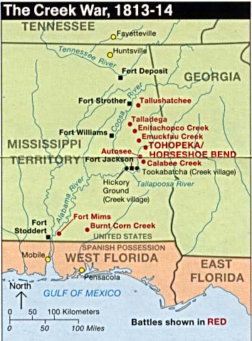
English: Map of sites of the
Creek War originally listed at
https://legacy.lib.utexas.edu/maps/alabama.html |
|||
| Source | https://legacy.lib.utexas.edu/maps/national_parks/horseshoe_bend_war_1813-14.jpg | |||
| Author | US National Park Service | |||
| Permission ( Reusing this file) |
|
File history
Click on a date/time to view the file as it appeared at that time.
| Date/Time | Thumbnail | Dimensions | User | Comment | |
|---|---|---|---|---|---|
| current | 21:08, 6 January 2018 |
| 354 × 478 (46 KB) | MarginalCost | {{Information |Description ={{en|1=Map of sites of the w:Creek War originally listed at https://legacy.lib.utexas.edu/maps/alabama.html}} |Source =https://legacy.lib.utexas.edu/maps/national_parks/horseshoe_bend_war_1813-14.jpg |Author... |
File usage
The following pages on the English Wikipedia use this file (pages on other projects are not listed):
Global file usage
The following other wikis use this file:
- Usage on es.wikipedia.org
- Usage on no.wikipedia.org
- Usage on pt.wikipedia.org
- Usage on www.wikidata.org
No higher resolution available.
Creek_war_1813-14.jpg (354 × 478 pixels, file size: 46 KB, MIME type: image/jpeg)
| This is a file from the
Wikimedia Commons. Information from its
description page there is shown below. Commons is a freely licensed media file repository. You can help. |
| Description |
English: Map of sites of the
Creek War originally listed at
https://legacy.lib.utexas.edu/maps/alabama.html |
|||
| Source | https://legacy.lib.utexas.edu/maps/national_parks/horseshoe_bend_war_1813-14.jpg | |||
| Author | US National Park Service | |||
| Permission ( Reusing this file) |
|
File history
Click on a date/time to view the file as it appeared at that time.
| Date/Time | Thumbnail | Dimensions | User | Comment | |
|---|---|---|---|---|---|
| current | 21:08, 6 January 2018 |
| 354 × 478 (46 KB) | MarginalCost | {{Information |Description ={{en|1=Map of sites of the w:Creek War originally listed at https://legacy.lib.utexas.edu/maps/alabama.html}} |Source =https://legacy.lib.utexas.edu/maps/national_parks/horseshoe_bend_war_1813-14.jpg |Author... |
File usage
The following pages on the English Wikipedia use this file (pages on other projects are not listed):
Global file usage
The following other wikis use this file:
- Usage on es.wikipedia.org
- Usage on no.wikipedia.org
- Usage on pt.wikipedia.org
- Usage on www.wikidata.org