No higher resolution available.
County_Armagh2.png (304 × 208 pixels, file size: 36 KB, MIME type: image/png)
| This is a file from the
Wikimedia Commons. Information from its
description page there is shown below. Commons is a freely licensed media file repository. You can help. |
Summary
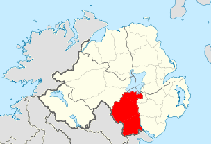
| Description |
English: Map of County Armagh, Northern Ireland |
| Date | 19:14, 1 July 2010 (UTC) |
| Source | Island of Ireland location map.svg |
| Author | Mabuska (talk) 19:14, 1 July 2010 (UTC) |
Licensing

|
Permission is granted to copy, distribute and/or modify this document under the terms of the GNU Free Documentation License, Version 1.2 or any later version published by the Free Software Foundation; with no Invariant Sections, no Front-Cover Texts, and no Back-Cover Texts. A copy of the license is included in the section entitled GNU Free Documentation License. |
File history
Click on a date/time to view the file as it appeared at that time.
| Date/Time | Thumbnail | Dimensions | User | Comment | |
|---|---|---|---|---|---|
| current | 21:50, 1 July 2010 |
| 304 × 208 (36 KB) | Mabuska | wider scope to include entire of Donegal |
| 19:14, 1 July 2010 |
 | 254 × 202 (33 KB) | Mabuska | {{Information |Description = Map of County Armagh, Northern Ireland |Source = File:Island of Ireland location map.svg |Date = ~~~~~ |Author = ~~~~ |Permission = |other_versions = }} |
File usage
The following pages on the English Wikipedia use this file (pages on other projects are not listed):
Metadata
No higher resolution available.
County_Armagh2.png (304 × 208 pixels, file size: 36 KB, MIME type: image/png)
| This is a file from the
Wikimedia Commons. Information from its
description page there is shown below. Commons is a freely licensed media file repository. You can help. |
Summary
| Description |
English: Map of County Armagh, Northern Ireland |
| Date | 19:14, 1 July 2010 (UTC) |
| Source | Island of Ireland location map.svg |
| Author | Mabuska (talk) 19:14, 1 July 2010 (UTC) |
Licensing
|
|
Permission is granted to copy, distribute and/or modify this document under the terms of the GNU Free Documentation License, Version 1.2 or any later version published by the Free Software Foundation; with no Invariant Sections, no Front-Cover Texts, and no Back-Cover Texts. A copy of the license is included in the section entitled GNU Free Documentation License. |
File history
Click on a date/time to view the file as it appeared at that time.
| Date/Time | Thumbnail | Dimensions | User | Comment | |
|---|---|---|---|---|---|
| current | 21:50, 1 July 2010 |
| 304 × 208 (36 KB) | Mabuska | wider scope to include entire of Donegal |
| 19:14, 1 July 2010 |
| 254 × 202 (33 KB) | Mabuska | {{Information |Description = Map of County Armagh, Northern Ireland |Source = File:Island of Ireland location map.svg |Date = ~~~~~ |Author = ~~~~ |Permission = |other_versions = }} |
File usage
The following pages on the English Wikipedia use this file (pages on other projects are not listed):