
Size of this preview:
509 × 599 pixels. Other resolutions:
204 × 240 pixels |
408 × 480 pixels |
652 × 768 pixels |
870 × 1,024 pixels |
1,740 × 2,048 pixels |
6,640 × 7,817 pixels.
Original file (6,640 × 7,817 pixels, file size: 9.51 MB, MIME type: image/jpeg)
| This is a file from the
Wikimedia Commons. Information from its
description page there is shown below. Commons is a freely licensed media file repository. You can help. |
Summary
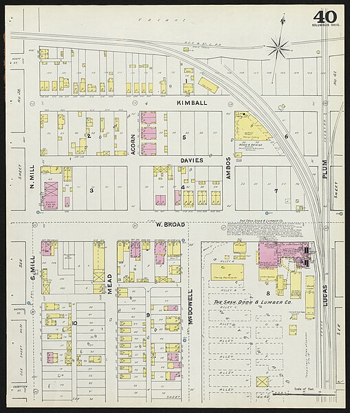
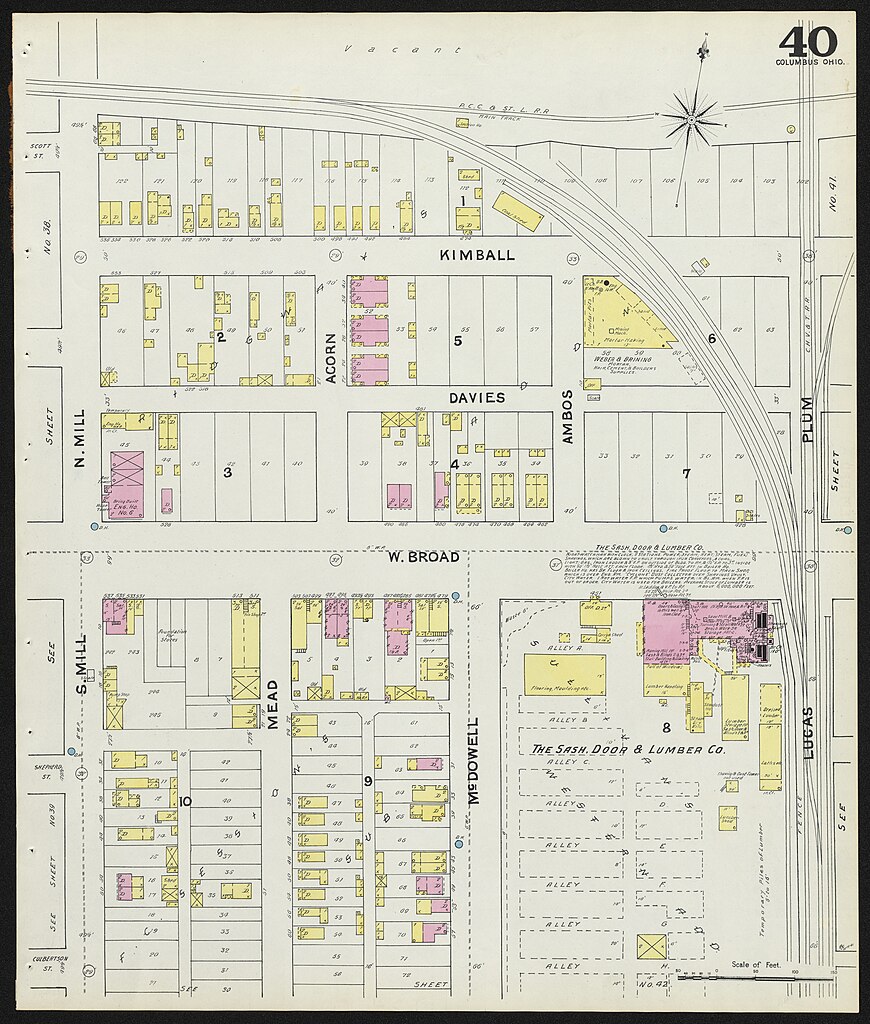
| Columbus, Delaware, Fairfield and Franklin counties, Ohio, 1891
(
|
|||||||||||||||||||||||||||
|---|---|---|---|---|---|---|---|---|---|---|---|---|---|---|---|---|---|---|---|---|---|---|---|---|---|---|---|
| Creator | |||||||||||||||||||||||||||
| Title |
Columbus, Delaware, Fairfield and Franklin counties, Ohio, 1891 |
||||||||||||||||||||||||||
| Description |
Digitization was supported by an Ohio History Fund grant. Maps are from the collection at Kent State University Libraries map collection (McGilvery Hall, Room 410). The Sanborn Maps are large scale street plans produced by the Sanborn Fire Insurance Company from 1867 to 1970. Sanborn Maps show the outline of each building including the location of windows and doors together with street names, street and sidewalk widths, property boundaries, building use, and house and block numbers. The maps display building materials, number of floors, and building purpose (if available). Businesses, churches, and government structures are often identified as well as the business type (cotton mill, automobile repair, etc.). An individual homeowner/occupier is not identified. These maps are used by a wide range of researchers including local historians to locate and identify buildings and neighborhoods, urban historians to study the growth of towns and cities, and environmentalists concerned about impact of new developments. The Library of Congress held three paper copies of the Sanborn maps for each state. In the early 1950’s, the Library of Congress distributed one set for each state to a state land grant university, and Kent State was chosen to house this important collection. |
||||||||||||||||||||||||||
| Date | 1891 | ||||||||||||||||||||||||||
| Collection |
|
||||||||||||||||||||||||||
| Source/Photographer |
|
||||||||||||||||||||||||||
| Permission ( Reusing this file) |
|
||||||||||||||||||||||||||
| Standardized rights statement |
|
||||||||||||||||||||||||||


.jpg)
File history
Click on a date/time to view the file as it appeared at that time.
| Date/Time | Thumbnail | Dimensions | User | Comment | |
|---|---|---|---|---|---|
| current | 09:47, 26 April 2022 |
| 6,640 × 7,817 (9.51 MB) | DPLA bot | Uploading DPLA ID b052b4a8ec41eb1a8151b5299953dc5d |
File usage
No pages on the English Wikipedia use this file (pages on other projects are not listed).
.jpg)
Size of this preview:
509 × 599 pixels. Other resolutions:
204 × 240 pixels |
408 × 480 pixels |
652 × 768 pixels |
870 × 1,024 pixels |
1,740 × 2,048 pixels |
6,640 × 7,817 pixels.
Original file (6,640 × 7,817 pixels, file size: 9.51 MB, MIME type: image/jpeg)
| This is a file from the
Wikimedia Commons. Information from its
description page there is shown below. Commons is a freely licensed media file repository. You can help. |
Summary
| Columbus, Delaware, Fairfield and Franklin counties, Ohio, 1891
(
|
|||||||||||||||||||||||||||
|---|---|---|---|---|---|---|---|---|---|---|---|---|---|---|---|---|---|---|---|---|---|---|---|---|---|---|---|
| Creator | |||||||||||||||||||||||||||
| Title |
Columbus, Delaware, Fairfield and Franklin counties, Ohio, 1891 |
||||||||||||||||||||||||||
| Description |
Digitization was supported by an Ohio History Fund grant. Maps are from the collection at Kent State University Libraries map collection (McGilvery Hall, Room 410). The Sanborn Maps are large scale street plans produced by the Sanborn Fire Insurance Company from 1867 to 1970. Sanborn Maps show the outline of each building including the location of windows and doors together with street names, street and sidewalk widths, property boundaries, building use, and house and block numbers. The maps display building materials, number of floors, and building purpose (if available). Businesses, churches, and government structures are often identified as well as the business type (cotton mill, automobile repair, etc.). An individual homeowner/occupier is not identified. These maps are used by a wide range of researchers including local historians to locate and identify buildings and neighborhoods, urban historians to study the growth of towns and cities, and environmentalists concerned about impact of new developments. The Library of Congress held three paper copies of the Sanborn maps for each state. In the early 1950’s, the Library of Congress distributed one set for each state to a state land grant university, and Kent State was chosen to house this important collection. |
||||||||||||||||||||||||||
| Date | 1891 | ||||||||||||||||||||||||||
| Collection |
|
||||||||||||||||||||||||||
| Source/Photographer |
|
||||||||||||||||||||||||||
| Permission ( Reusing this file) |
|
||||||||||||||||||||||||||
| Standardized rights statement |
|
||||||||||||||||||||||||||
File history
Click on a date/time to view the file as it appeared at that time.
| Date/Time | Thumbnail | Dimensions | User | Comment | |
|---|---|---|---|---|---|
| current | 09:47, 26 April 2022 |
| 6,640 × 7,817 (9.51 MB) | DPLA bot | Uploading DPLA ID b052b4a8ec41eb1a8151b5299953dc5d |
File usage
No pages on the English Wikipedia use this file (pages on other projects are not listed).