
Original file (2,000 × 1,447 pixels, file size: 536 KB, MIME type: image/jpeg)
| This is a file from the
Wikimedia Commons. Information from its
description page there is shown below. Commons is a freely licensed media file repository. You can help. |

|
This incident map image could be re-created using
vector graphics as an
SVG file. This has several advantages; see
Commons:Media for cleanup for more information. If an SVG form of this image is available, please upload it and afterwards replace this template with
{{
vector version available|new image name}}
.
It is recommended to name the SVG file “Colorado county map highlighting 14 counties affected by 2013 flooding.svg”—then the template Vector version available (or Vva) does not need the new image name parameter. |


| Description |
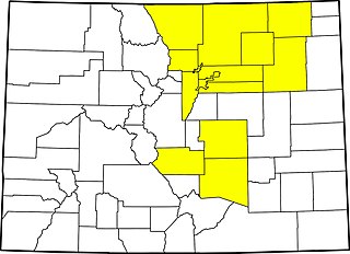
English: County map of
Colorado highlighting 14 counties declared disaster emergencies on September 13, 2013 by governor in
2013 Colorado flooding: Adams, Arapahoe, Broomfield, Boulder, Denver, El Paso, Fremont, Jefferson, Larimer, Logan, Morgan, Pueblo, Washington and Weld. |
||
| Date | Based on information current as of September 13, 2013 | ||
| Source | Modification by uploader of File:Map of Colorado counties, blank.svg | ||
| Author | Source file by Augiasstallputzer~commonswiki | ||
| Permission ( Reusing this file) |
|
File history
Click on a date/time to view the file as it appeared at that time.
| Date/Time | Thumbnail | Dimensions | User | Comment | |
|---|---|---|---|---|---|
| current | 16:53, 16 September 2013 |
| 2,000 × 1,447 (536 KB) | Postdlf | {{Information |Description={{en|County map of {{w|Colorado}} highlighting 14 counties declared disaster emergencies on September 13, 2013 by governor in {{w|2013 Colorado flooding}}: Adams, Arapahoe, Broomfield, Boulder, Denver, El Paso, Fremont, Jeffe... |
File usage
Global file usage
The following other wikis use this file:
- Usage on es.wikipedia.org
Metadata
Original file (2,000 × 1,447 pixels, file size: 536 KB, MIME type: image/jpeg)
| This is a file from the
Wikimedia Commons. Information from its
description page there is shown below. Commons is a freely licensed media file repository. You can help. |
|
|
This incident map image could be re-created using
vector graphics as an
SVG file. This has several advantages; see
Commons:Media for cleanup for more information. If an SVG form of this image is available, please upload it and afterwards replace this template with
{{
vector version available|new image name}}
.
It is recommended to name the SVG file “Colorado county map highlighting 14 counties affected by 2013 flooding.svg”—then the template Vector version available (or Vva) does not need the new image name parameter. |
| Description |
English: County map of
Colorado highlighting 14 counties declared disaster emergencies on September 13, 2013 by governor in
2013 Colorado flooding: Adams, Arapahoe, Broomfield, Boulder, Denver, El Paso, Fremont, Jefferson, Larimer, Logan, Morgan, Pueblo, Washington and Weld. |
||
| Date | Based on information current as of September 13, 2013 | ||
| Source | Modification by uploader of File:Map of Colorado counties, blank.svg | ||
| Author | Source file by Augiasstallputzer~commonswiki | ||
| Permission ( Reusing this file) |
|
File history
Click on a date/time to view the file as it appeared at that time.
| Date/Time | Thumbnail | Dimensions | User | Comment | |
|---|---|---|---|---|---|
| current | 16:53, 16 September 2013 |
| 2,000 × 1,447 (536 KB) | Postdlf | {{Information |Description={{en|County map of {{w|Colorado}} highlighting 14 counties declared disaster emergencies on September 13, 2013 by governor in {{w|2013 Colorado flooding}}: Adams, Arapahoe, Broomfield, Boulder, Denver, El Paso, Fremont, Jeffe... |
File usage
Global file usage
The following other wikis use this file:
- Usage on es.wikipedia.org