
Size of this PNG preview of this SVG file:
575 × 599 pixels. Other resolutions:
230 × 240 pixels |
460 × 480 pixels |
737 × 768 pixels |
982 × 1,024 pixels |
1,964 × 2,048 pixels |
2,000 × 2,085 pixels.
Original file (SVG file, nominally 2,000 × 2,085 pixels, file size: 824 KB)
| This is a file from the
Wikimedia Commons. Information from its
description page there is shown below. Commons is a freely licensed media file repository. You can help. |
Summary
| Description |
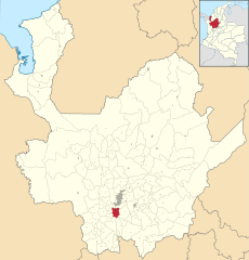
Español: Mapa del Municipio de Caldas, Antioquia (Colombia) |
| Date | |
| Source | Own work |
| Author | Milenioscuro |
Licensing
I, the copyright holder of this work, hereby publish it under the following license:
This file is licensed under the
Creative Commons
Attribution-Share Alike 3.0 Unported license.
- You are free:
- to share – to copy, distribute and transmit the work
- to remix – to adapt the work
- Under the following conditions:
- attribution – You must give appropriate credit, provide a link to the license, and indicate if changes were made. You may do so in any reasonable manner, but not in any way that suggests the licensor endorses you or your use.
- share alike – If you remix, transform, or build upon the material, you must distribute your contributions under the same or compatible license as the original.
File history
Click on a date/time to view the file as it appeared at that time.
| Date/Time | Thumbnail | Dimensions | User | Comment | |
|---|---|---|---|---|---|
| current | 04:22, 11 August 2016 |
| 2,000 × 2,085 (824 KB) | Milenioscuro | estilo |
| 22:28, 17 July 2012 |
 | 1,942 × 2,024 (1.05 MB) | Milenioscuro | limites de acuerdo a mapas oficiales | |
| 00:30, 25 December 2010 |
 | 1,995 × 2,018 (775 KB) | Milenioscuro | {{Information |Description={{es|1=Mapa del Municipio de Caldas, Antioquia (Colombia)}} |Source={{own}} |Author= Shadowxfox |Date=2010-12-24 |Permission= |other_versions= }} [[Category:SVG maps of municipalities of Antioquia (Colombia)] |
File usage
The following pages on the English Wikipedia use this file (pages on other projects are not listed):
Global file usage
The following other wikis use this file:
- Usage on avk.wikipedia.org
- Usage on de.wikipedia.org
- Usage on el.wikipedia.org
- Usage on eo.wikipedia.org
- Usage on es.wikipedia.org
- Usage on fa.wikipedia.org
- Usage on fr.wikipedia.org
- Usage on gd.wikipedia.org
- Usage on ie.wikipedia.org
- Usage on ilo.wikipedia.org
- Usage on it.wikipedia.org
- Usage on nl.wikipedia.org
- Usage on pt.wikipedia.org
- Usage on ro.wikipedia.org
- Usage on ru.wikipedia.org
- Usage on sco.wikipedia.org
- Usage on vi.wikipedia.org
- Usage on www.wikidata.org
- Usage on zh-min-nan.wikipedia.org
Metadata
Size of this PNG preview of this SVG file:
575 × 599 pixels. Other resolutions:
230 × 240 pixels |
460 × 480 pixels |
737 × 768 pixels |
982 × 1,024 pixels |
1,964 × 2,048 pixels |
2,000 × 2,085 pixels.
Original file (SVG file, nominally 2,000 × 2,085 pixels, file size: 824 KB)
| This is a file from the
Wikimedia Commons. Information from its
description page there is shown below. Commons is a freely licensed media file repository. You can help. |
Summary
| Description |
Español: Mapa del Municipio de Caldas, Antioquia (Colombia) |
| Date | |
| Source | Own work |
| Author | Milenioscuro |
Licensing
I, the copyright holder of this work, hereby publish it under the following license:
This file is licensed under the
Creative Commons
Attribution-Share Alike 3.0 Unported license.
- You are free:
- to share – to copy, distribute and transmit the work
- to remix – to adapt the work
- Under the following conditions:
- attribution – You must give appropriate credit, provide a link to the license, and indicate if changes were made. You may do so in any reasonable manner, but not in any way that suggests the licensor endorses you or your use.
- share alike – If you remix, transform, or build upon the material, you must distribute your contributions under the same or compatible license as the original.
File history
Click on a date/time to view the file as it appeared at that time.
| Date/Time | Thumbnail | Dimensions | User | Comment | |
|---|---|---|---|---|---|
| current | 04:22, 11 August 2016 |
| 2,000 × 2,085 (824 KB) | Milenioscuro | estilo |
| 22:28, 17 July 2012 |
| 1,942 × 2,024 (1.05 MB) | Milenioscuro | limites de acuerdo a mapas oficiales | |
| 00:30, 25 December 2010 |
| 1,995 × 2,018 (775 KB) | Milenioscuro | {{Information |Description={{es|1=Mapa del Municipio de Caldas, Antioquia (Colombia)}} |Source={{own}} |Author= Shadowxfox |Date=2010-12-24 |Permission= |other_versions= }} [[Category:SVG maps of municipalities of Antioquia (Colombia)] |
File usage
The following pages on the English Wikipedia use this file (pages on other projects are not listed):
Global file usage
The following other wikis use this file:
- Usage on avk.wikipedia.org
- Usage on de.wikipedia.org
- Usage on el.wikipedia.org
- Usage on eo.wikipedia.org
- Usage on es.wikipedia.org
- Usage on fa.wikipedia.org
- Usage on fr.wikipedia.org
- Usage on gd.wikipedia.org
- Usage on ie.wikipedia.org
- Usage on ilo.wikipedia.org
- Usage on it.wikipedia.org
- Usage on nl.wikipedia.org
- Usage on pt.wikipedia.org
- Usage on ro.wikipedia.org
- Usage on ru.wikipedia.org
- Usage on sco.wikipedia.org
- Usage on vi.wikipedia.org
- Usage on www.wikidata.org
- Usage on zh-min-nan.wikipedia.org