
Size of this PNG preview of this SVG file:
800 × 437 pixels. Other resolutions:
320 × 175 pixels |
640 × 350 pixels |
1,024 × 559 pixels |
1,280 × 699 pixels |
2,560 × 1,399 pixels |
1,596 × 872 pixels.
Original file (SVG file, nominally 1,596 × 872 pixels, file size: 192 KB)
| This is a file from the
Wikimedia Commons. Information from its
description page there is shown below. Commons is a freely licensed media file repository. You can help. |
Summary
| Description |
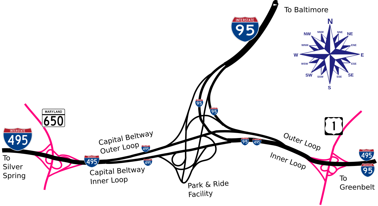
English: Drawing of the interconnect between Interstate 495 (The Capital Beltway) and Interstate 95 near Greenbelt, Maryland. |
| Date | |
| Source |
Created by Uploader This W3C-unspecified
vector image was created with
Inkscape . |
| Author | User:Rfc1394 |
Licensing
I, the copyright holder of this work, hereby publish it under the following licenses:

|
This library is free software; you can redistribute it and/or modify it under the terms of the GNU Lesser General Public License as published by the Free Software Foundation; either version 2.1 of the License, or (at your option) any later version. This library is distributed in the hope that it will be useful, but without any warranty; without even the implied warranty of merchantability or fitness for a particular purpose. See version 2.1 and version 3 of the GNU Lesser General Public License for more details. |
|
|
Permission is granted to copy, distribute and/or modify this document under the terms of the GNU Free Documentation License, Version 1.2 or any later version published by the Free Software Foundation; with no Invariant Sections, no Front-Cover Texts, and no Back-Cover Texts. A copy of the license is included in the section entitled GNU Free Documentation License. |
This file is licensed under the
Creative Commons
Attribution-Share Alike 3.0 Unported license.
- You are free:
- to share – to copy, distribute and transmit the work
- to remix – to adapt the work
- Under the following conditions:
- attribution – You must give appropriate credit, provide a link to the license, and indicate if changes were made. You may do so in any reasonable manner, but not in any way that suggests the licensor endorses you or your use.
- share alike – If you remix, transform, or build upon the material, you must distribute your contributions under the same or compatible license as the original.
You may select the license of your choice.
File history
Click on a date/time to view the file as it appeared at that time.
| Date/Time | Thumbnail | Dimensions | User | Comment | |
|---|---|---|---|---|---|
| current | 22:58, 22 August 2008 |
| 1,596 × 872 (192 KB) | Rfc1394 | Readjust size and positioning of labels |
| 22:49, 22 August 2008 |
 | 1,596 × 872 (193 KB) | Rfc1394 | Correct positioning of Interstate shields | |
| 22:45, 22 August 2008 |
 | 1,596 × 872 (180 KB) | Rfc1394 | Add some local roads (US 1 and MD 650) and the interchanges with them | |
| 21:40, 22 August 2008 |
 | 1,448 × 778 (109 KB) | Rfc1394 | {{Information |Description={{en|1=Drawing of the interconnect between Interstate 495 (The Capital Beltway) and Interstate 95 near Greenbelt, Maryland.}} |Source=Created by Uploader<br/>{{Inkscape}} |Author= User:Rfc1394 |Date=August 22, 2008 |Permissio |
File usage
The following pages on the English Wikipedia use this file (pages on other projects are not listed):
Global file usage
The following other wikis use this file:
- Usage on ja.wikipedia.org
- Usage on www.mediawiki.org
Size of this PNG preview of this SVG file:
800 × 437 pixels. Other resolutions:
320 × 175 pixels |
640 × 350 pixels |
1,024 × 559 pixels |
1,280 × 699 pixels |
2,560 × 1,399 pixels |
1,596 × 872 pixels.
Original file (SVG file, nominally 1,596 × 872 pixels, file size: 192 KB)
| This is a file from the
Wikimedia Commons. Information from its
description page there is shown below. Commons is a freely licensed media file repository. You can help. |
Summary
| Description |
English: Drawing of the interconnect between Interstate 495 (The Capital Beltway) and Interstate 95 near Greenbelt, Maryland. |
| Date | |
| Source |
Created by Uploader This W3C-unspecified
vector image was created with
Inkscape . |
| Author | User:Rfc1394 |
Licensing
I, the copyright holder of this work, hereby publish it under the following licenses:
|
|
This library is free software; you can redistribute it and/or modify it under the terms of the GNU Lesser General Public License as published by the Free Software Foundation; either version 2.1 of the License, or (at your option) any later version. This library is distributed in the hope that it will be useful, but without any warranty; without even the implied warranty of merchantability or fitness for a particular purpose. See version 2.1 and version 3 of the GNU Lesser General Public License for more details. |
|
|
Permission is granted to copy, distribute and/or modify this document under the terms of the GNU Free Documentation License, Version 1.2 or any later version published by the Free Software Foundation; with no Invariant Sections, no Front-Cover Texts, and no Back-Cover Texts. A copy of the license is included in the section entitled GNU Free Documentation License. |
This file is licensed under the
Creative Commons
Attribution-Share Alike 3.0 Unported license.
- You are free:
- to share – to copy, distribute and transmit the work
- to remix – to adapt the work
- Under the following conditions:
- attribution – You must give appropriate credit, provide a link to the license, and indicate if changes were made. You may do so in any reasonable manner, but not in any way that suggests the licensor endorses you or your use.
- share alike – If you remix, transform, or build upon the material, you must distribute your contributions under the same or compatible license as the original.
You may select the license of your choice.
File history
Click on a date/time to view the file as it appeared at that time.
| Date/Time | Thumbnail | Dimensions | User | Comment | |
|---|---|---|---|---|---|
| current | 22:58, 22 August 2008 |
| 1,596 × 872 (192 KB) | Rfc1394 | Readjust size and positioning of labels |
| 22:49, 22 August 2008 |
| 1,596 × 872 (193 KB) | Rfc1394 | Correct positioning of Interstate shields | |
| 22:45, 22 August 2008 |
| 1,596 × 872 (180 KB) | Rfc1394 | Add some local roads (US 1 and MD 650) and the interchanges with them | |
| 21:40, 22 August 2008 |
| 1,448 × 778 (109 KB) | Rfc1394 | {{Information |Description={{en|1=Drawing of the interconnect between Interstate 495 (The Capital Beltway) and Interstate 95 near Greenbelt, Maryland.}} |Source=Created by Uploader<br/>{{Inkscape}} |Author= User:Rfc1394 |Date=August 22, 2008 |Permissio |
File usage
The following pages on the English Wikipedia use this file (pages on other projects are not listed):
Global file usage
The following other wikis use this file:
- Usage on ja.wikipedia.org
- Usage on www.mediawiki.org