Photos • Location


No higher resolution available.
Clay_Coton_-_geograph.org.uk_-_59876.jpg (640 × 480 pixels, file size: 124 KB, MIME type: image/jpeg)
| This is a file from the
Wikimedia Commons. Information from its
description page there is shown below. Commons is a freely licensed media file repository. You can help. |
Summary
| Description |
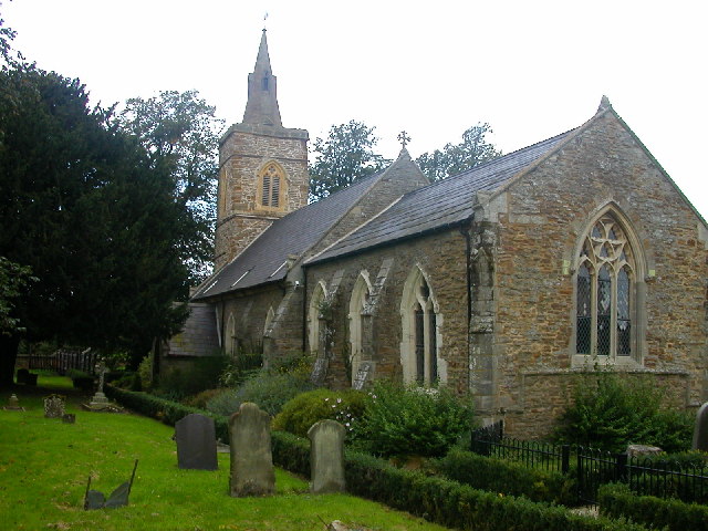
English: Clay Coton. Formerly St Andrew's church built in 1340, disused since the 1950s, now converted into a very large house. A public footpath runs through the centre of the picture and the grounds are a mixture of garden and gravestones.
|
|
| Date | ||
| Source | From geograph.org.uk | |
| Author | Ian Rob | |
| Attribution ( required by the license) | Ian Rob / Clay Coton / | |
| Camera location | | View this and other nearby images on: OpenStreetMap |
|
|---|
_heading:270.00&language=en)
| Object location | | View this and other nearby images on: OpenStreetMap |
|
|---|
_heading:270.00&language=en)
Licensing

|
This image was taken from the
Geograph project collection. See
this photograph's page on the Geograph website for the photographer's contact details. The copyright on this image is owned by Ian Rob and is licensed for reuse under the
Creative Commons Attribution-ShareAlike 2.0 license.
|
This file is licensed under the
Creative Commons
Attribution-Share Alike 2.0 Generic license.
Attribution: Ian Rob
- You are free:
- to share – to copy, distribute and transmit the work
- to remix – to adapt the work
- Under the following conditions:
- attribution – You must give appropriate credit, provide a link to the license, and indicate if changes were made. You may do so in any reasonable manner, but not in any way that suggests the licensor endorses you or your use.
- share alike – If you remix, transform, or build upon the material, you must distribute your contributions under the same or compatible license as the original.
File history
Click on a date/time to view the file as it appeared at that time.
| Date/Time | Thumbnail | Dimensions | User | Comment | |
|---|---|---|---|---|---|
| current | 13:53, 30 January 2010 |
| 640 × 480 (124 KB) | GeographBot | == {{int:filedesc}} == {{Information |description={{en|1=Clay Coton. Formerly St Andrew's church built in 1340, disused since the 1950s, now converted into a very large house. A public footpath runs through the centre of the picture and the grounds are a |
File usage
The following pages on the English Wikipedia use this file (pages on other projects are not listed):
Global file usage
The following other wikis use this file:
- Usage on ceb.wikipedia.org
- Usage on cy.wikipedia.org
- Usage on fr.wikipedia.org
- Usage on lld.wikipedia.org
- Usage on pl.wikipedia.org
- Usage on www.wikidata.org
Metadata
No higher resolution available.
Clay_Coton_-_geograph.org.uk_-_59876.jpg (640 × 480 pixels, file size: 124 KB, MIME type: image/jpeg)
| This is a file from the
Wikimedia Commons. Information from its
description page there is shown below. Commons is a freely licensed media file repository. You can help. |
Summary
| Description |
English: Clay Coton. Formerly St Andrew's church built in 1340, disused since the 1950s, now converted into a very large house. A public footpath runs through the centre of the picture and the grounds are a mixture of garden and gravestones.
|
|
| Date | ||
| Source | From geograph.org.uk | |
| Author | Ian Rob | |
| Attribution ( required by the license) | Ian Rob / Clay Coton / | |
| Camera location | | View this and other nearby images on: OpenStreetMap |
|
|---|
| Object location | | View this and other nearby images on: OpenStreetMap |
|
|---|
Licensing
|
|
This image was taken from the
Geograph project collection. See
this photograph's page on the Geograph website for the photographer's contact details. The copyright on this image is owned by Ian Rob and is licensed for reuse under the
Creative Commons Attribution-ShareAlike 2.0 license.
|
This file is licensed under the
Creative Commons
Attribution-Share Alike 2.0 Generic license.
Attribution: Ian Rob
- You are free:
- to share – to copy, distribute and transmit the work
- to remix – to adapt the work
- Under the following conditions:
- attribution – You must give appropriate credit, provide a link to the license, and indicate if changes were made. You may do so in any reasonable manner, but not in any way that suggests the licensor endorses you or your use.
- share alike – If you remix, transform, or build upon the material, you must distribute your contributions under the same or compatible license as the original.
File history
Click on a date/time to view the file as it appeared at that time.
| Date/Time | Thumbnail | Dimensions | User | Comment | |
|---|---|---|---|---|---|
| current | 13:53, 30 January 2010 |
| 640 × 480 (124 KB) | GeographBot | == {{int:filedesc}} == {{Information |description={{en|1=Clay Coton. Formerly St Andrew's church built in 1340, disused since the 1950s, now converted into a very large house. A public footpath runs through the centre of the picture and the grounds are a |
File usage
The following pages on the English Wikipedia use this file (pages on other projects are not listed):
Global file usage
The following other wikis use this file:
- Usage on ceb.wikipedia.org
- Usage on cy.wikipedia.org
- Usage on fr.wikipedia.org
- Usage on lld.wikipedia.org
- Usage on pl.wikipedia.org
- Usage on www.wikidata.org