
Size of this PNG preview of this SVG file:
201 × 158 pixels. Other resolutions:
305 × 240 pixels |
611 × 480 pixels |
977 × 768 pixels |
1,280 × 1,006 pixels |
2,560 × 2,012 pixels.
Original file (SVG file, nominally 201 × 158 pixels, file size: 92 KB)
| This is a file from the
Wikimedia Commons. Information from its
description page there is shown below. Commons is a freely licensed media file repository. You can help. |
Summary
| Description |
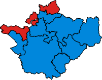
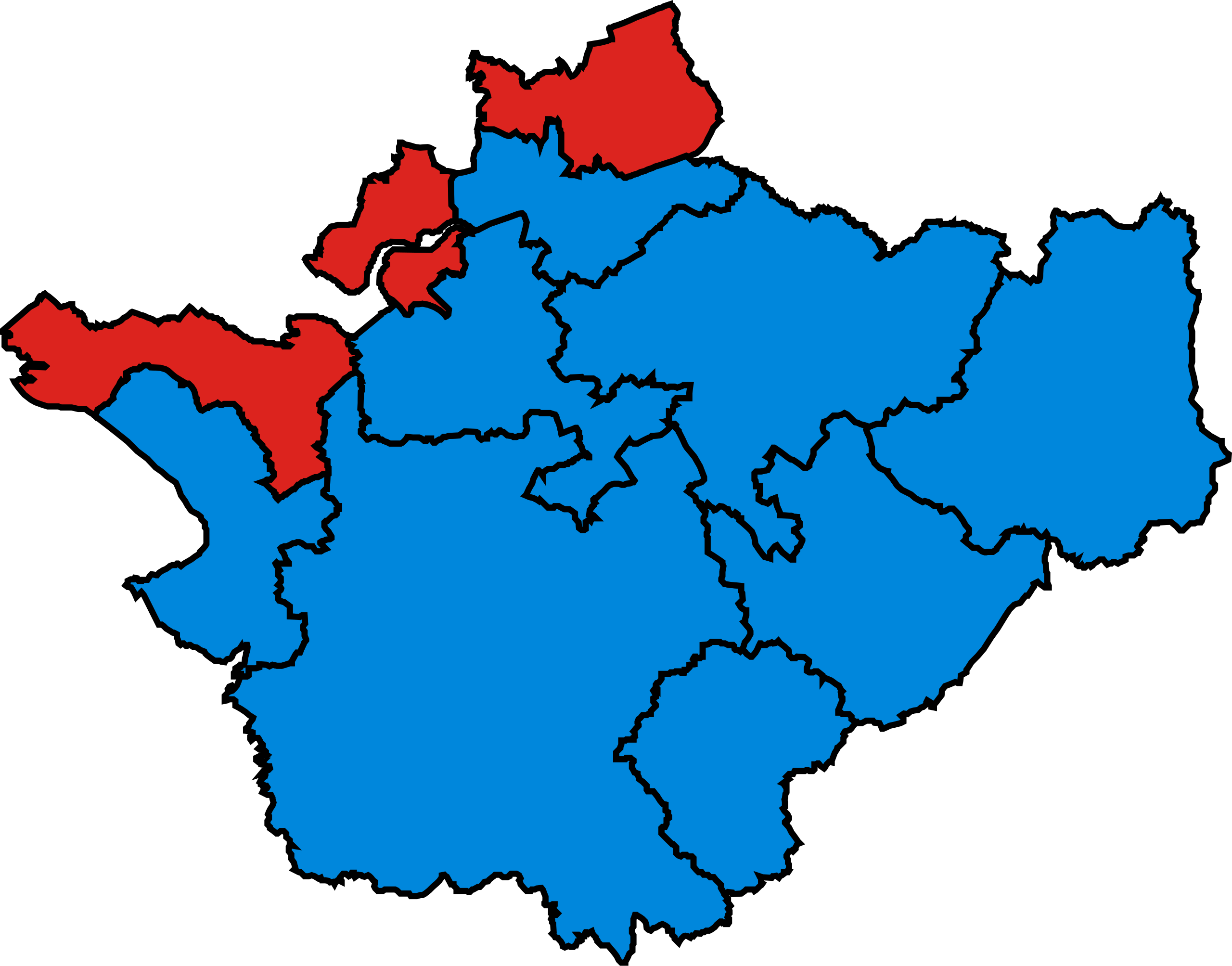
English: Map of Parliamentary constituencies in Cheshire, showing the results by party in the general election of 2010. |
| Source | Own work |
| Author | Wereon |
Licensing
| I, the copyright holder of this work, release this work into the
public domain. This applies worldwide. In some countries this may not be legally possible; if so: I grant anyone the right to use this work for any purpose, without any conditions, unless such conditions are required by law. |
File history
Click on a date/time to view the file as it appeared at that time.
| Date/Time | Thumbnail | Dimensions | User | Comment | |
|---|---|---|---|---|---|
| current | 20:44, 16 December 2019 |
| 201 × 158 (92 KB) | The- | Cropped |
| 07:05, 12 June 2016 |
 | 211 × 167 (130 KB) | RazorThunder3 | Party colours changed to match that in Wikipedia:Index of United Kingdom political parties meta attributes | |
| 20:51, 7 May 2010 |
 | 211 × 167 (188 KB) | Wereon | == {{int:filedesc}} == Map of Parliamentary constituencies in Cheshire, showing the results by party in the general election of 2010. == {{int:license}} == {{PD-self}} Category:Locator maps of parliamentary constituencies of Cheshire [[Category:2010 |
File usage
The following pages on the English Wikipedia use this file (pages on other projects are not listed):
Metadata
Size of this PNG preview of this SVG file:
201 × 158 pixels. Other resolutions:
305 × 240 pixels |
611 × 480 pixels |
977 × 768 pixels |
1,280 × 1,006 pixels |
2,560 × 2,012 pixels.
Original file (SVG file, nominally 201 × 158 pixels, file size: 92 KB)
| This is a file from the
Wikimedia Commons. Information from its
description page there is shown below. Commons is a freely licensed media file repository. You can help. |
Summary
| Description |
English: Map of Parliamentary constituencies in Cheshire, showing the results by party in the general election of 2010. |
| Source | Own work |
| Author | Wereon |
Licensing
| I, the copyright holder of this work, release this work into the
public domain. This applies worldwide. In some countries this may not be legally possible; if so: I grant anyone the right to use this work for any purpose, without any conditions, unless such conditions are required by law. |
File history
Click on a date/time to view the file as it appeared at that time.
| Date/Time | Thumbnail | Dimensions | User | Comment | |
|---|---|---|---|---|---|
| current | 20:44, 16 December 2019 |
| 201 × 158 (92 KB) | The- | Cropped |
| 07:05, 12 June 2016 |
| 211 × 167 (130 KB) | RazorThunder3 | Party colours changed to match that in Wikipedia:Index of United Kingdom political parties meta attributes | |
| 20:51, 7 May 2010 |
| 211 × 167 (188 KB) | Wereon | == {{int:filedesc}} == Map of Parliamentary constituencies in Cheshire, showing the results by party in the general election of 2010. == {{int:license}} == {{PD-self}} Category:Locator maps of parliamentary constituencies of Cheshire [[Category:2010 |
File usage
The following pages on the English Wikipedia use this file (pages on other projects are not listed):