Photos • Location


Size of this preview:
800 × 533 pixels. Other resolutions:
320 × 213 pixels |
640 × 427 pixels |
1,024 × 683 pixels |
1,280 × 853 pixels |
2,400 × 1,600 pixels.
Original file (2,400 × 1,600 pixels, file size: 2.77 MB, MIME type: image/jpeg)
| This is a file from the
Wikimedia Commons. Information from its
description page there is shown below. Commons is a freely licensed media file repository. You can help. |
Summary
| Description |
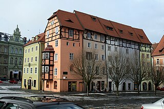
English: Špalíček - a complex of eleven medieval houses on the market square in
Cheb,
Czech Republic
Čeština: Špalíček - komplex jedenácti středověkých domů na náměstí Jiřího z Poděbrad v
Chebu západní Čechy
Deutsch: Bürgerhäuser am Stöckl in Eger – Cheb, nám. Krále Jiřího z Poděbrad 504/44 bis 500/48 (Ostseite). |
| Date | |
| Source | Own work |
| Author | Karelj |
| Camera location |
| View this and other nearby images on: OpenStreetMap |
|
|---|
Licensing
| I, the copyright holder of this work, release this work into the
public domain. This applies worldwide. In some countries this may not be legally possible; if so: I grant anyone the right to use this work for any purpose, without any conditions, unless such conditions are required by law. |
File history
Click on a date/time to view the file as it appeared at that time.
| Date/Time | Thumbnail | Dimensions | User | Comment | |
|---|---|---|---|---|---|
| current | 19:44, 30 January 2009 |
| 2,400 × 1,600 (2.77 MB) | Karelj | {{Information |Description={{en|1=Špalíček - a complex of eleven medieval houses on the market square in Cheb, Czech Republic}} {{cs|1=Špalíček - komplex jedenácti středověkých domů na náměstí Jiří |
File usage
The following pages on the English Wikipedia use this file (pages on other projects are not listed):
Global file usage
The following other wikis use this file:
- Usage on be-tarask.wikipedia.org
- Usage on be.wikipedia.org
- Usage on cs.wikipedia.org
- Usage on de.wikipedia.org
- Usage on de.wikivoyage.org
- Usage on en.wikivoyage.org
- Usage on eo.wikipedia.org
- Usage on ru.wikipedia.org
- Usage on www.wikidata.org
Metadata
Size of this preview:
800 × 533 pixels. Other resolutions:
320 × 213 pixels |
640 × 427 pixels |
1,024 × 683 pixels |
1,280 × 853 pixels |
2,400 × 1,600 pixels.
Original file (2,400 × 1,600 pixels, file size: 2.77 MB, MIME type: image/jpeg)
| This is a file from the
Wikimedia Commons. Information from its
description page there is shown below. Commons is a freely licensed media file repository. You can help. |
Summary
| Description |
English: Špalíček - a complex of eleven medieval houses on the market square in
Cheb,
Czech Republic
Čeština: Špalíček - komplex jedenácti středověkých domů na náměstí Jiřího z Poděbrad v
Chebu západní Čechy
Deutsch: Bürgerhäuser am Stöckl in Eger – Cheb, nám. Krále Jiřího z Poděbrad 504/44 bis 500/48 (Ostseite). |
| Date | |
| Source | Own work |
| Author | Karelj |
| Camera location |
| View this and other nearby images on: OpenStreetMap |
|
|---|
Licensing
| I, the copyright holder of this work, release this work into the
public domain. This applies worldwide. In some countries this may not be legally possible; if so: I grant anyone the right to use this work for any purpose, without any conditions, unless such conditions are required by law. |
File history
Click on a date/time to view the file as it appeared at that time.
| Date/Time | Thumbnail | Dimensions | User | Comment | |
|---|---|---|---|---|---|
| current | 19:44, 30 January 2009 |
| 2,400 × 1,600 (2.77 MB) | Karelj | {{Information |Description={{en|1=Špalíček - a complex of eleven medieval houses on the market square in Cheb, Czech Republic}} {{cs|1=Špalíček - komplex jedenácti středověkých domů na náměstí Jiří |
File usage
The following pages on the English Wikipedia use this file (pages on other projects are not listed):
Global file usage
The following other wikis use this file:
- Usage on be-tarask.wikipedia.org
- Usage on be.wikipedia.org
- Usage on cs.wikipedia.org
- Usage on de.wikipedia.org
- Usage on de.wikivoyage.org
- Usage on en.wikivoyage.org
- Usage on eo.wikipedia.org
- Usage on ru.wikipedia.org
- Usage on www.wikidata.org