Photos • Location


Size of this preview:
399 × 599 pixels. Other resolutions:
160 × 240 pixels |
320 × 480 pixels |
899 × 1,349 pixels.
Original file (899 × 1,349 pixels, file size: 197 KB, MIME type: image/jpeg)
| This is a file from the
Wikimedia Commons. Information from its
description page there is shown below. Commons is a freely licensed media file repository. You can help. |
Summary
| Camera location |
| View this and other nearby images on: OpenStreetMap |
|
|---|
| Description |
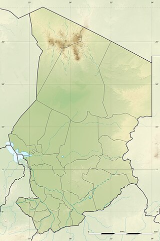
English: Blank physical map of
Chad as since the 2008-02 reform of the Regions, for geo-location purposes.
Français : Carte physique vierge du
Tchad telle que depuis la réforme des Régions de février 2008, destinée à la géolocalisation. Scale: 1:5,600,000 (precision: 1,400 m)
Geographic limits of the map:
|
||
| Date | 2009-11, updated 2011-07 | ||
| Source |
Own work
|
||
| Author | Eric Gaba ( Sting - fr:Sting) | ||
| Permission ( Reusing this file) |
|
||
| Other versions |
|

Licensing
I, the copyright holder of this work, hereby publish it under the following licenses:
This file is licensed under the
Creative Commons
Attribution-Share Alike 3.0 Unported license.
- You are free:
- to share – to copy, distribute and transmit the work
- to remix – to adapt the work
- Under the following conditions:
- attribution – You must give appropriate credit, provide a link to the license, and indicate if changes were made. You may do so in any reasonable manner, but not in any way that suggests the licensor endorses you or your use.
- share alike – If you remix, transform, or build upon the material, you must distribute your contributions under the same or compatible license as the original.

|
Permission is granted to copy, distribute and/or modify this document under the terms of the GNU Free Documentation License, Version 1.2 or any later version published by the Free Software Foundation; with no Invariant Sections, no Front-Cover Texts, and no Back-Cover Texts. A copy of the license is included in the section entitled GNU Free Documentation License. |
You may select the license of your choice.
File history
Click on a date/time to view the file as it appeared at that time.
| Date/Time | Thumbnail | Dimensions | User | Comment | |
|---|---|---|---|---|---|
| current | 22:21, 14 July 2011 |
| 899 × 1,349 (197 KB) | Sting | Sudan/South Sudan 2011-07 border update |
| 13:20, 19 July 2010 |
 | 899 × 1,349 (241 KB) | Sting | Color profile | |
| 23:26, 23 November 2009 |
 | 899 × 1,349 (242 KB) | Sting | == {{int:filedesc}} == {{Location|15|27|00|N|18|43|30|E|scale:7000000}} <br/> {{Information |Description={{en|Blank physical map of Chad as after the 2008-02 reform of the Regions, for geo-location purposes.}} {{fr|Carte physique vierge du [[ |
File usage
The following pages on the English Wikipedia use this file (pages on other projects are not listed):
- 1990 Chadian coup d'état
- Abou-Deïa Airport
- Abou Telfane Faunal Reserve
- Abéché Airport
- Aouk National Park
- Baga Sola bombings
- Bahr Salamat Faunal Reserve
- Battle of Maaten al-Sarra
- Beinamar Faunal Reserve
- Binder-Léré Faunal Reserve
- Bongor
- Breidjing Camp
- Chad National Museum
- Emi Koussi
- Ennedi Plateau
- Fada Airport
- Fada Archei Faunal Reserve
- Faya-Largeau Airport
- Goz Beïda National Park
- Guelta d'Archei
- Iro Lake
- Kébir Airport
- Lake Chad
- Lake Fitri
- Lake Katam
- Lake Tréné
- Lake Wey
- Lake Yoa
- Lakes of Ounianga
- Léré Lake
- Manda National Park
- Moundou Airport
- N'Djamena
- N'Djamena Grand Mosque
- Ouadi Doum airstrike
- Ouadi Rimé-Ouadi Achim Faunal Reserve
- Sena Oura National Park
- Soborom Hot Springs
- Tarso Ahon
- Tarso Emi Chi
- Tarso Toh
- Tarso Toon
- Tarso Voon
- Tarso Yega
- Tibesti Mountains
- Toussidé
- Yaho (archeological site)
- Zakouma National Park
- User:Clumsystiggy/sandbox
- Module:Location map/data/Chad
- Module:Location map/data/Chad/doc
Global file usage
The following other wikis use this file:
- Usage on ar.wikipedia.org
- Usage on azb.wikipedia.org
- Usage on az.wikipedia.org
- Usage on ban.wikipedia.org
- Usage on ba.wikipedia.org
- Usage on bcl.wikipedia.org
- Usage on be-tarask.wikipedia.org
- Usage on be.wikipedia.org
- Usage on bg.wikipedia.org
View more global usage of this file.
Metadata
Size of this preview:
399 × 599 pixels. Other resolutions:
160 × 240 pixels |
320 × 480 pixels |
899 × 1,349 pixels.
Original file (899 × 1,349 pixels, file size: 197 KB, MIME type: image/jpeg)
| This is a file from the
Wikimedia Commons. Information from its
description page there is shown below. Commons is a freely licensed media file repository. You can help. |
Summary
| Camera location |
| View this and other nearby images on: OpenStreetMap |
|
|---|
| Description |
English: Blank physical map of
Chad as since the 2008-02 reform of the Regions, for geo-location purposes.
Français : Carte physique vierge du
Tchad telle que depuis la réforme des Régions de février 2008, destinée à la géolocalisation. Scale: 1:5,600,000 (precision: 1,400 m)
Geographic limits of the map:
|
||
| Date | 2009-11, updated 2011-07 | ||
| Source |
Own work
|
||
| Author | Eric Gaba ( Sting - fr:Sting) | ||
| Permission ( Reusing this file) |
|
||
| Other versions |
|
Licensing
I, the copyright holder of this work, hereby publish it under the following licenses:
This file is licensed under the
Creative Commons
Attribution-Share Alike 3.0 Unported license.
- You are free:
- to share – to copy, distribute and transmit the work
- to remix – to adapt the work
- Under the following conditions:
- attribution – You must give appropriate credit, provide a link to the license, and indicate if changes were made. You may do so in any reasonable manner, but not in any way that suggests the licensor endorses you or your use.
- share alike – If you remix, transform, or build upon the material, you must distribute your contributions under the same or compatible license as the original.
|
|
Permission is granted to copy, distribute and/or modify this document under the terms of the GNU Free Documentation License, Version 1.2 or any later version published by the Free Software Foundation; with no Invariant Sections, no Front-Cover Texts, and no Back-Cover Texts. A copy of the license is included in the section entitled GNU Free Documentation License. |
You may select the license of your choice.
File history
Click on a date/time to view the file as it appeared at that time.
| Date/Time | Thumbnail | Dimensions | User | Comment | |
|---|---|---|---|---|---|
| current | 22:21, 14 July 2011 |
| 899 × 1,349 (197 KB) | Sting | Sudan/South Sudan 2011-07 border update |
| 13:20, 19 July 2010 |
| 899 × 1,349 (241 KB) | Sting | Color profile | |
| 23:26, 23 November 2009 |
| 899 × 1,349 (242 KB) | Sting | == {{int:filedesc}} == {{Location|15|27|00|N|18|43|30|E|scale:7000000}} <br/> {{Information |Description={{en|Blank physical map of Chad as after the 2008-02 reform of the Regions, for geo-location purposes.}} {{fr|Carte physique vierge du [[ |
File usage
The following pages on the English Wikipedia use this file (pages on other projects are not listed):
- 1990 Chadian coup d'état
- Abou-Deïa Airport
- Abou Telfane Faunal Reserve
- Abéché Airport
- Aouk National Park
- Baga Sola bombings
- Bahr Salamat Faunal Reserve
- Battle of Maaten al-Sarra
- Beinamar Faunal Reserve
- Binder-Léré Faunal Reserve
- Bongor
- Breidjing Camp
- Chad National Museum
- Emi Koussi
- Ennedi Plateau
- Fada Airport
- Fada Archei Faunal Reserve
- Faya-Largeau Airport
- Goz Beïda National Park
- Guelta d'Archei
- Iro Lake
- Kébir Airport
- Lake Chad
- Lake Fitri
- Lake Katam
- Lake Tréné
- Lake Wey
- Lake Yoa
- Lakes of Ounianga
- Léré Lake
- Manda National Park
- Moundou Airport
- N'Djamena
- N'Djamena Grand Mosque
- Ouadi Doum airstrike
- Ouadi Rimé-Ouadi Achim Faunal Reserve
- Sena Oura National Park
- Soborom Hot Springs
- Tarso Ahon
- Tarso Emi Chi
- Tarso Toh
- Tarso Toon
- Tarso Voon
- Tarso Yega
- Tibesti Mountains
- Toussidé
- Yaho (archeological site)
- Zakouma National Park
- User:Clumsystiggy/sandbox
- Module:Location map/data/Chad
- Module:Location map/data/Chad/doc
Global file usage
The following other wikis use this file:
- Usage on ar.wikipedia.org
- Usage on azb.wikipedia.org
- Usage on az.wikipedia.org
- Usage on ban.wikipedia.org
- Usage on ba.wikipedia.org
- Usage on bcl.wikipedia.org
- Usage on be-tarask.wikipedia.org
- Usage on be.wikipedia.org
- Usage on bg.wikipedia.org
View more global usage of this file.