Size of this preview:
798 × 600 pixels. Other resolutions:
320 × 240 pixels |
639 × 480 pixels |
1,022 × 768 pixels |
1,280 × 962 pixels |
2,560 × 1,924 pixels |
3,928 × 2,952 pixels.
Original file (3,928 × 2,952 pixels, file size: 3.08 MB, MIME type: image/png)
| This is a file from the
Wikimedia Commons. Information from its
description page there is shown below. Commons is a freely licensed media file repository. You can help. |
Summary
| Description |
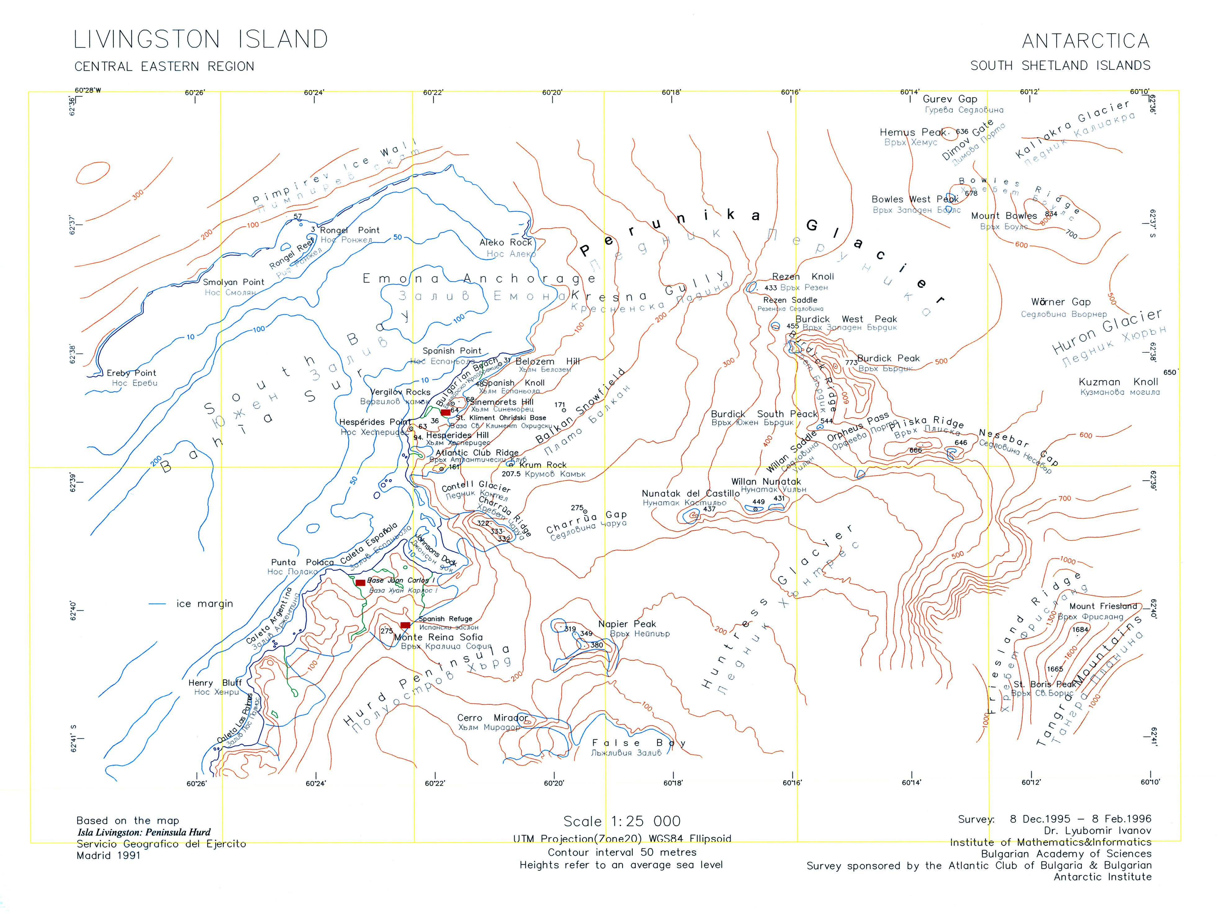
English: A version of the original 1996 map "L.L. Ivanov. Livingston Island: Central-Eastern Region. Scale 1:25000 topographic map. Sofia: Antarctic Place-names Commission of Bulgaria, 1996." uploaded by the author of that map who is also the CEO of the Antarctic Place-names Commission. |
| Date | |
| Source | Own work |
| Author | Apcbg |
| Other versions | File:Central-Eastern-Livingston-Map-1996.png |
Licensing
I, the copyright holder of this work, hereby publish it under the following licenses:
This file is licensed under the
Creative Commons
Attribution-Share Alike 3.0 Unported license.
- You are free:
- to share – to copy, distribute and transmit the work
- to remix – to adapt the work
- Under the following conditions:
- attribution – You must give appropriate credit, provide a link to the license, and indicate if changes were made. You may do so in any reasonable manner, but not in any way that suggests the licensor endorses you or your use.
- share alike – If you remix, transform, or build upon the material, you must distribute your contributions under the same or compatible license as the original.

|
Permission is granted to copy, distribute and/or modify this document under the terms of the GNU Free Documentation License, Version 1.2 or any later version published by the Free Software Foundation; with no Invariant Sections, no Front-Cover Texts, and no Back-Cover Texts. A copy of the license is included in the section entitled GNU Free Documentation License. |
You may select the license of your choice.
File history
Click on a date/time to view the file as it appeared at that time.
| Date/Time | Thumbnail | Dimensions | User | Comment | |
|---|---|---|---|---|---|
| current | 10:45, 27 July 2010 |
| 3,928 × 2,952 (3.08 MB) | Apcbg | Minor fixes. |
| 08:47, 27 July 2010 |
 | 3,928 × 2,952 (33.23 MB) | Apcbg | {{Information |Description={{en|1=A version of the original 1996 map ''L.L. Ivanov. Livingston Island: Central-Eastern Region. Scale 1:25000 topographic map. Sofia: Antarctic Place-names Commission of Bulgaria, 1996.'' uploaded by the author of that map. |
File usage
The following pages on the English Wikipedia use this file (pages on other projects are not listed):
- Aleko Point
- Atlantic Club Ridge
- Balkan Snowfield
- Belozem Hill
- Bowles West Peak
- Bulgarian Beach
- Charrúa Gap
- Contell Glacier
- Dimov Gate
- Emona Anchorage
- Gurev Gap
- Hesperides Hill
- Kresna Gully
- Krum Rock
- Mount Friesland
- Pimpirev Ice Wall
- Rezen Knoll
- Rezen Saddle
- Rongel Point
- Rongel Reef
- Sea Lion Glacier
- Sea Lion Tarn
- Sinemorets Hill
- Smolyan Point
- Spanish Knoll
- Spanish Point (Antarctica)
- St. Boris Peak
- Vergilov Rocks
- Willan Nunatak
- Willan Saddle
Global file usage
The following other wikis use this file:
- Usage on ar.wikipedia.org
- Usage on bg.wikipedia.org
- Usage on he.wikipedia.org
- Usage on it.wikipedia.org
- Usage on nl.wikipedia.org
- Usage on pt.wikipedia.org
- Usage on uk.wikipedia.org
Size of this preview:
798 × 600 pixels. Other resolutions:
320 × 240 pixels |
639 × 480 pixels |
1,022 × 768 pixels |
1,280 × 962 pixels |
2,560 × 1,924 pixels |
3,928 × 2,952 pixels.
Original file (3,928 × 2,952 pixels, file size: 3.08 MB, MIME type: image/png)
| This is a file from the
Wikimedia Commons. Information from its
description page there is shown below. Commons is a freely licensed media file repository. You can help. |
Summary
| Description |
English: A version of the original 1996 map "L.L. Ivanov. Livingston Island: Central-Eastern Region. Scale 1:25000 topographic map. Sofia: Antarctic Place-names Commission of Bulgaria, 1996." uploaded by the author of that map who is also the CEO of the Antarctic Place-names Commission. |
| Date | |
| Source | Own work |
| Author | Apcbg |
| Other versions | File:Central-Eastern-Livingston-Map-1996.png |
Licensing
I, the copyright holder of this work, hereby publish it under the following licenses:
This file is licensed under the
Creative Commons
Attribution-Share Alike 3.0 Unported license.
- You are free:
- to share – to copy, distribute and transmit the work
- to remix – to adapt the work
- Under the following conditions:
- attribution – You must give appropriate credit, provide a link to the license, and indicate if changes were made. You may do so in any reasonable manner, but not in any way that suggests the licensor endorses you or your use.
- share alike – If you remix, transform, or build upon the material, you must distribute your contributions under the same or compatible license as the original.
|
|
Permission is granted to copy, distribute and/or modify this document under the terms of the GNU Free Documentation License, Version 1.2 or any later version published by the Free Software Foundation; with no Invariant Sections, no Front-Cover Texts, and no Back-Cover Texts. A copy of the license is included in the section entitled GNU Free Documentation License. |
You may select the license of your choice.
File history
Click on a date/time to view the file as it appeared at that time.
| Date/Time | Thumbnail | Dimensions | User | Comment | |
|---|---|---|---|---|---|
| current | 10:45, 27 July 2010 |
| 3,928 × 2,952 (3.08 MB) | Apcbg | Minor fixes. |
| 08:47, 27 July 2010 |
| 3,928 × 2,952 (33.23 MB) | Apcbg | {{Information |Description={{en|1=A version of the original 1996 map ''L.L. Ivanov. Livingston Island: Central-Eastern Region. Scale 1:25000 topographic map. Sofia: Antarctic Place-names Commission of Bulgaria, 1996.'' uploaded by the author of that map. |
File usage
The following pages on the English Wikipedia use this file (pages on other projects are not listed):
- Aleko Point
- Atlantic Club Ridge
- Balkan Snowfield
- Belozem Hill
- Bowles West Peak
- Bulgarian Beach
- Charrúa Gap
- Contell Glacier
- Dimov Gate
- Emona Anchorage
- Gurev Gap
- Hesperides Hill
- Kresna Gully
- Krum Rock
- Mount Friesland
- Pimpirev Ice Wall
- Rezen Knoll
- Rezen Saddle
- Rongel Point
- Rongel Reef
- Sea Lion Glacier
- Sea Lion Tarn
- Sinemorets Hill
- Smolyan Point
- Spanish Knoll
- Spanish Point (Antarctica)
- St. Boris Peak
- Vergilov Rocks
- Willan Nunatak
- Willan Saddle
Global file usage
The following other wikis use this file:
- Usage on ar.wikipedia.org
- Usage on bg.wikipedia.org
- Usage on he.wikipedia.org
- Usage on it.wikipedia.org
- Usage on nl.wikipedia.org
- Usage on pt.wikipedia.org
- Usage on uk.wikipedia.org