
Size of this preview:
469 × 600 pixels. Other resolutions:
188 × 240 pixels |
375 × 480 pixels |
601 × 768 pixels |
801 × 1,024 pixels |
2,262 × 2,892 pixels.
Original file (2,262 × 2,892 pixels, file size: 874 KB, MIME type: image/jpeg)
| This is a file from the
Wikimedia Commons. Information from its
description page there is shown below. Commons is a freely licensed media file repository. You can help. |
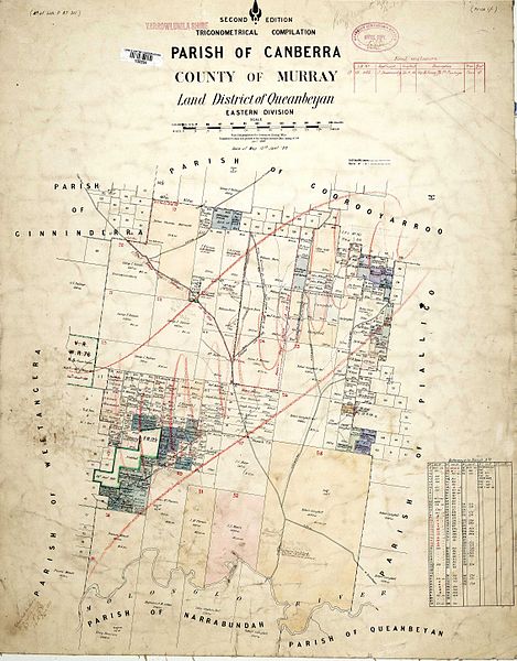
| Description | Map of the former parish of Canberra, County of Murray, Land District of Queanbeyan, Eastern Division, New South Wales. The parish includes most of what is now North Canberra including Mt. Ainslie and Black Mountain, which are both marked on the map. The main road running from the top-left to the bottom-right is roughly in the same position as the Barton Highway and Limestone Avenue. Most of the Molonglo River shown at the south of the map is now part of Lake Burley Griffin. Unfortunately it has been marked with red writing over the top "cancelled". | |||||||||||||||||||||
| Date | ||||||||||||||||||||||
| Source | New South Wales Department of Lands Parish map preservation project. [1] | |||||||||||||||||||||
| Author | Government Printing Office, NSW | |||||||||||||||||||||
| Permission ( Reusing this file) |
govt map, copyright expires 50 years after it was made [2], so:
|
|||||||||||||||||||||

File history
Click on a date/time to view the file as it appeared at that time.
| Date/Time | Thumbnail | Dimensions | User | Comment | |
|---|---|---|---|---|---|
| current | 09:16, 20 August 2007 |
| 2,262 × 2,892 (874 KB) | Roke~commonswiki | {{Information |Description=Map of the former parish of Canberra, County of Murray, Land District of Queanbeyan, Eastern Division, NSW. The parish includes most of what is now North Canberra including Mt. Ainslie and Black Mountain, wh |
File usage
The following pages on the English Wikipedia use this file (pages on other projects are not listed):
Metadata
Size of this preview:
469 × 600 pixels. Other resolutions:
188 × 240 pixels |
375 × 480 pixels |
601 × 768 pixels |
801 × 1,024 pixels |
2,262 × 2,892 pixels.
Original file (2,262 × 2,892 pixels, file size: 874 KB, MIME type: image/jpeg)
| This is a file from the
Wikimedia Commons. Information from its
description page there is shown below. Commons is a freely licensed media file repository. You can help. |
| Description | Map of the former parish of Canberra, County of Murray, Land District of Queanbeyan, Eastern Division, New South Wales. The parish includes most of what is now North Canberra including Mt. Ainslie and Black Mountain, which are both marked on the map. The main road running from the top-left to the bottom-right is roughly in the same position as the Barton Highway and Limestone Avenue. Most of the Molonglo River shown at the south of the map is now part of Lake Burley Griffin. Unfortunately it has been marked with red writing over the top "cancelled". | |||||||||||||||||||||
| Date | ||||||||||||||||||||||
| Source | New South Wales Department of Lands Parish map preservation project. [1] | |||||||||||||||||||||
| Author | Government Printing Office, NSW | |||||||||||||||||||||
| Permission ( Reusing this file) |
govt map, copyright expires 50 years after it was made [2], so:
|
|||||||||||||||||||||
File history
Click on a date/time to view the file as it appeared at that time.
| Date/Time | Thumbnail | Dimensions | User | Comment | |
|---|---|---|---|---|---|
| current | 09:16, 20 August 2007 |
| 2,262 × 2,892 (874 KB) | Roke~commonswiki | {{Information |Description=Map of the former parish of Canberra, County of Murray, Land District of Queanbeyan, Eastern Division, NSW. The parish includes most of what is now North Canberra including Mt. Ainslie and Black Mountain, wh |
File usage
The following pages on the English Wikipedia use this file (pages on other projects are not listed):