
Original file (1,000 × 864 pixels, file size: 61 KB, MIME type: image/png)
| This is a file from the
Wikimedia Commons. Information from its
description page there is shown below. Commons is a freely licensed media file repository. You can help. |
Summary
| Description |
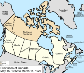
Map of the provinces and territories of Canada as they were between 1912 and 1927. On May 15 1912, parts of the Northwest Territories were given to Manitoba, Ontario, and Quebec. Also in 1912, the name officially changed from "North-West Territories" to "Northwest Territories". On March 1 1927, a disputed part of Quebec was given to the Dominion of Newfoundland by a court. Made by User:Golbez. |
| Date | 13 February 2006 (original upload date) |
| Source | No machine-readable source provided. Own work assumed (based on copyright claims). |
| Author | No machine-readable author provided. Golbez assumed (based on copyright claims). |
Licensing

|
Permission is granted to copy, distribute and/or modify this document under the terms of the GNU Free Documentation License, Version 1.2 or any later version published by the Free Software Foundation; with no Invariant Sections, no Front-Cover Texts, and no Back-Cover Texts. A copy of the license is included in the section entitled GNU Free Documentation License. |
| This file is licensed under the Creative Commons Attribution-Share Alike 3.0 Unported license. | ||
| ||
| This licensing tag was added to this file as part of the GFDL licensing update. |
- You are free:
- to share – to copy, distribute and transmit the work
- to remix – to adapt the work
- Under the following conditions:
- attribution – You must give appropriate credit, provide a link to the license, and indicate if changes were made. You may do so in any reasonable manner, but not in any way that suggests the licensor endorses you or your use.
File history
Click on a date/time to view the file as it appeared at that time.
| Date/Time | Thumbnail | Dimensions | User | Comment | |
|---|---|---|---|---|---|
| current | 17:22, 14 July 2009 |
| 1,000 × 864 (61 KB) | Golbez | New color scheme, other borders |
| 09:59, 7 August 2006 |
 | 1,000 × 864 (47 KB) | Golbez | with legend | |
| 02:24, 18 February 2006 |
 | 1,000 × 864 (46 KB) | Golbez | Better version | |
| 23:49, 13 February 2006 |
 | 1,000 × 864 (41 KB) | Golbez | better colors | |
| 06:46, 13 February 2006 |
 | 1,000 × 864 (41 KB) | Golbez | Map of the provinces and territories of Canada as they were between 1912 and 1927. On May 15 1912, parts of the Northwest Territories were given to Manitoba, Ontario, and Quebec. On March 1 1927, a disputed part of Quebec was given to the Dominion of Newf |
File usage
Global file usage
The following other wikis use this file:
- Usage on de.wikipedia.org
- Usage on es.wikipedia.org
- Usage on fr.wikipedia.org
- Usage on it.wikipedia.org
- Usage on pt.wikipedia.org
- Usage on ru.wikipedia.org
- Usage on uk.wikipedia.org
- Usage on vi.wikipedia.org
- Usage on zh.wikipedia.org
Original file (1,000 × 864 pixels, file size: 61 KB, MIME type: image/png)
| This is a file from the
Wikimedia Commons. Information from its
description page there is shown below. Commons is a freely licensed media file repository. You can help. |
Summary
| Description |
Map of the provinces and territories of Canada as they were between 1912 and 1927. On May 15 1912, parts of the Northwest Territories were given to Manitoba, Ontario, and Quebec. Also in 1912, the name officially changed from "North-West Territories" to "Northwest Territories". On March 1 1927, a disputed part of Quebec was given to the Dominion of Newfoundland by a court. Made by User:Golbez. |
| Date | 13 February 2006 (original upload date) |
| Source | No machine-readable source provided. Own work assumed (based on copyright claims). |
| Author | No machine-readable author provided. Golbez assumed (based on copyright claims). |
Licensing
|
|
Permission is granted to copy, distribute and/or modify this document under the terms of the GNU Free Documentation License, Version 1.2 or any later version published by the Free Software Foundation; with no Invariant Sections, no Front-Cover Texts, and no Back-Cover Texts. A copy of the license is included in the section entitled GNU Free Documentation License. |
| This file is licensed under the Creative Commons Attribution-Share Alike 3.0 Unported license. | ||
| ||
| This licensing tag was added to this file as part of the GFDL licensing update. |
- You are free:
- to share – to copy, distribute and transmit the work
- to remix – to adapt the work
- Under the following conditions:
- attribution – You must give appropriate credit, provide a link to the license, and indicate if changes were made. You may do so in any reasonable manner, but not in any way that suggests the licensor endorses you or your use.
File history
Click on a date/time to view the file as it appeared at that time.
| Date/Time | Thumbnail | Dimensions | User | Comment | |
|---|---|---|---|---|---|
| current | 17:22, 14 July 2009 |
| 1,000 × 864 (61 KB) | Golbez | New color scheme, other borders |
| 09:59, 7 August 2006 |
| 1,000 × 864 (47 KB) | Golbez | with legend | |
| 02:24, 18 February 2006 |
| 1,000 × 864 (46 KB) | Golbez | Better version | |
| 23:49, 13 February 2006 |
| 1,000 × 864 (41 KB) | Golbez | better colors | |
| 06:46, 13 February 2006 |
| 1,000 × 864 (41 KB) | Golbez | Map of the provinces and territories of Canada as they were between 1912 and 1927. On May 15 1912, parts of the Northwest Territories were given to Manitoba, Ontario, and Quebec. On March 1 1927, a disputed part of Quebec was given to the Dominion of Newf |
File usage
Global file usage
The following other wikis use this file:
- Usage on de.wikipedia.org
- Usage on es.wikipedia.org
- Usage on fr.wikipedia.org
- Usage on it.wikipedia.org
- Usage on pt.wikipedia.org
- Usage on ru.wikipedia.org
- Usage on uk.wikipedia.org
- Usage on vi.wikipedia.org
- Usage on zh.wikipedia.org