
Size of this PNG preview of this SVG file:
800 × 474 pixels. Other resolutions:
320 × 190 pixels |
640 × 380 pixels |
1,024 × 607 pixels |
1,280 × 759 pixels |
2,560 × 1,518 pixels |
1,027 × 609 pixels.
Original file (SVG file, nominally 1,027 × 609 pixels, file size: 486 KB)
| This is a file from the
Wikimedia Commons. Information from its
description page there is shown below. Commons is a freely licensed media file repository. You can help. |
Summary
| Description |
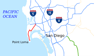
English: This is a map of State Route 209 in California, created in
w:Quantum GIS. |
| Date | |
| Source | NHPN, California State GIS |
| Author | User:Rschen7754 |
Licensing
I, the copyright holder of this work, hereby publish it under the following license:
This file is licensed under the
Creative Commons
Attribution-Share Alike 3.0 Unported license.
- You are free:
- to share – to copy, distribute and transmit the work
- to remix – to adapt the work
- Under the following conditions:
- attribution – You must give appropriate credit, provide a link to the license, and indicate if changes were made. You may do so in any reasonable manner, but not in any way that suggests the licensor endorses you or your use.
- share alike – If you remix, transform, or build upon the material, you must distribute your contributions under the same or compatible license as the original.
File history
Click on a date/time to view the file as it appeared at that time.
| Date/Time | Thumbnail | Dimensions | User | Comment | |
|---|---|---|---|---|---|
| current | 20:34, 26 August 2013 |
| 1,027 × 609 (486 KB) | Rschen7754 | labels |
| 18:43, 26 August 2013 |
 | 1,027 × 609 (339 KB) | Rschen7754 | new map | |
| 00:13, 13 February 2008 |
 | 1,152 × 640 (52 KB) | NE2 | == Summary == This is a map of former State Route 209 in California. Email me if you would like a copy of the GIS data I created for the highways. Category:California State Route 209 [[Category:Maps of state highways in Cali |
File usage
The following pages on the English Wikipedia use this file (pages on other projects are not listed):
Global file usage
The following other wikis use this file:
- Usage on de.wikipedia.org
- Usage on es.wikipedia.org
- Usage on www.wikidata.org
Metadata
Size of this PNG preview of this SVG file:
800 × 474 pixels. Other resolutions:
320 × 190 pixels |
640 × 380 pixels |
1,024 × 607 pixels |
1,280 × 759 pixels |
2,560 × 1,518 pixels |
1,027 × 609 pixels.
Original file (SVG file, nominally 1,027 × 609 pixels, file size: 486 KB)
| This is a file from the
Wikimedia Commons. Information from its
description page there is shown below. Commons is a freely licensed media file repository. You can help. |
Summary
| Description |
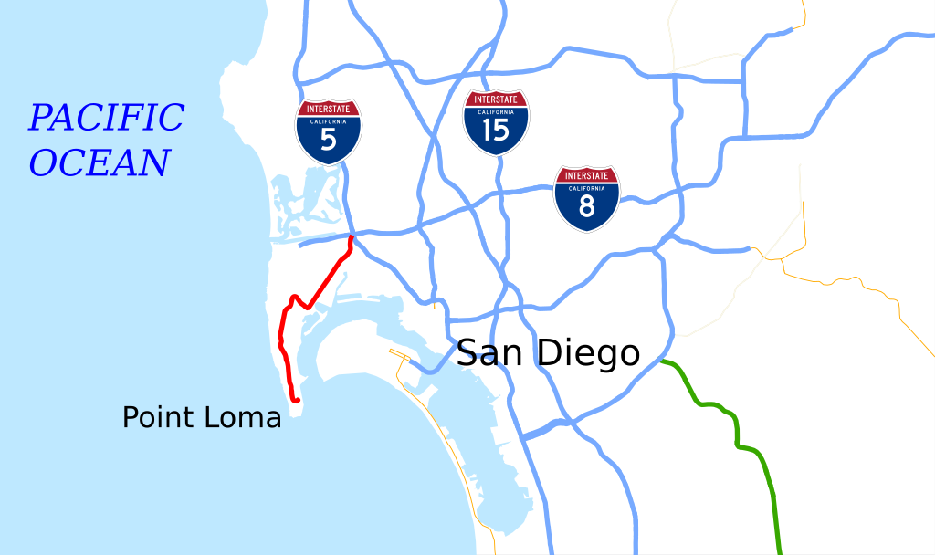
English: This is a map of State Route 209 in California, created in
w:Quantum GIS. |
| Date | |
| Source | NHPN, California State GIS |
| Author | User:Rschen7754 |
Licensing
I, the copyright holder of this work, hereby publish it under the following license:
This file is licensed under the
Creative Commons
Attribution-Share Alike 3.0 Unported license.
- You are free:
- to share – to copy, distribute and transmit the work
- to remix – to adapt the work
- Under the following conditions:
- attribution – You must give appropriate credit, provide a link to the license, and indicate if changes were made. You may do so in any reasonable manner, but not in any way that suggests the licensor endorses you or your use.
- share alike – If you remix, transform, or build upon the material, you must distribute your contributions under the same or compatible license as the original.
File history
Click on a date/time to view the file as it appeared at that time.
| Date/Time | Thumbnail | Dimensions | User | Comment | |
|---|---|---|---|---|---|
| current | 20:34, 26 August 2013 |
| 1,027 × 609 (486 KB) | Rschen7754 | labels |
| 18:43, 26 August 2013 |
| 1,027 × 609 (339 KB) | Rschen7754 | new map | |
| 00:13, 13 February 2008 |
| 1,152 × 640 (52 KB) | NE2 | == Summary == This is a map of former State Route 209 in California. Email me if you would like a copy of the GIS data I created for the highways. Category:California State Route 209 [[Category:Maps of state highways in Cali |
File usage
The following pages on the English Wikipedia use this file (pages on other projects are not listed):
Global file usage
The following other wikis use this file:
- Usage on de.wikipedia.org
- Usage on es.wikipedia.org
- Usage on www.wikidata.org