No higher resolution available.
CIS-Map.png (538 × 186 pixels, file size: 8 KB, MIME type: image/png)
| This is a file from the
Wikimedia Commons. Information from its
description page there is shown below. Commons is a freely licensed media file repository. You can help. |
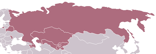
Commonwealth of Independent States - Map
| This work has been released into the
public domain by its author,
Aris Katsaris at
English Wikipedia. This applies worldwide. In some countries this may not be legally possible; if so: Aris Katsaris grants anyone the right to use this work for any purpose, without any conditions, unless such conditions are required by law. |
File history
Click on a date/time to view the file as it appeared at that time.
| Date/Time | Thumbnail | Dimensions | User | Comment | |
|---|---|---|---|---|---|
| current | 21:04, 19 March 2014 |
| 538 × 186 (8 KB) | A2D2 | Update |
| 03:03, 30 April 2005 |
| 538 × 186 (4 KB) | Messhermit~commonswiki | Commonwealth of Independent States - Map {{PD-user-en| Aris Katsaris}} |
File usage
The following pages on the English Wikipedia use this file (pages on other projects are not listed):
Global file usage
The following other wikis use this file:
- Usage on af.wikipedia.org
- Usage on hif.wikipedia.org
- Usage on id.wikipedia.org
- Usage on kn.wikipedia.org
- Usage on ko.wikipedia.org
- Usage on lt.wikipedia.org
- Usage on mwl.wikipedia.org
- Usage on no.wikipedia.org
- Usage on pl.wiktionary.org
- Usage on pt.wikipedia.org
- Usage on ro.wikipedia.org
- Usage on ru.wikipedia.org
- Usage on su.wikipedia.org
- Usage on vi.wikipedia.org
- Usage on zh-yue.wikipedia.org
No higher resolution available.
CIS-Map.png (538 × 186 pixels, file size: 8 KB, MIME type: image/png)
| This is a file from the
Wikimedia Commons. Information from its
description page there is shown below. Commons is a freely licensed media file repository. You can help. |
Commonwealth of Independent States - Map
| This work has been released into the
public domain by its author,
Aris Katsaris at
English Wikipedia. This applies worldwide. In some countries this may not be legally possible; if so: Aris Katsaris grants anyone the right to use this work for any purpose, without any conditions, unless such conditions are required by law. |
File history
Click on a date/time to view the file as it appeared at that time.
| Date/Time | Thumbnail | Dimensions | User | Comment | |
|---|---|---|---|---|---|
| current | 21:04, 19 March 2014 |
| 538 × 186 (8 KB) | A2D2 | Update |
| 03:03, 30 April 2005 |
| 538 × 186 (4 KB) | Messhermit~commonswiki | Commonwealth of Independent States - Map {{PD-user-en| Aris Katsaris}} |
File usage
The following pages on the English Wikipedia use this file (pages on other projects are not listed):
Global file usage
The following other wikis use this file:
- Usage on af.wikipedia.org
- Usage on hif.wikipedia.org
- Usage on id.wikipedia.org
- Usage on kn.wikipedia.org
- Usage on ko.wikipedia.org
- Usage on lt.wikipedia.org
- Usage on mwl.wikipedia.org
- Usage on no.wikipedia.org
- Usage on pl.wiktionary.org
- Usage on pt.wikipedia.org
- Usage on ro.wikipedia.org
- Usage on ru.wikipedia.org
- Usage on su.wikipedia.org
- Usage on vi.wikipedia.org
- Usage on zh-yue.wikipedia.org