
Size of this PNG preview of this SVG file:
704 × 600 pixels. Other resolutions:
282 × 240 pixels |
564 × 480 pixels |
902 × 768 pixels |
1,202 × 1,024 pixels |
2,404 × 2,048 pixels |
1,425 × 1,214 pixels.
Original file (SVG file, nominally 1,425 × 1,214 pixels, file size: 313 KB)
| This is a file from the
Wikimedia Commons. Information from its
description page there is shown below. Commons is a freely licensed media file repository. You can help. |
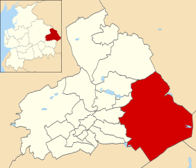
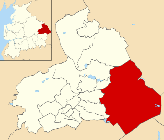
| Description | Map of Pendle, Lancashire, UK with electoral wards shown. Boulsworth ward highlighted. Equirectangular map projection on WGS 84 datum, with N/S stretched 165% Geographic limits: *West: 2.35W *East: 2.04W *North: 53.96N *South: 53.80N |
| Date | (UTC) |
| Source | |
| Author |
|
.svg)
I, the copyright holder of this work, hereby publish it under the following license:
This file is licensed under the
Creative Commons
Attribution-Share Alike 3.0 Unported license.
- You are free:
- to share – to copy, distribute and transmit the work
- to remix – to adapt the work
- Under the following conditions:
- attribution – You must give appropriate credit, provide a link to the license, and indicate if changes were made. You may do so in any reasonable manner, but not in any way that suggests the licensor endorses you or your use.
- share alike – If you remix, transform, or build upon the material, you must distribute your contributions under the same or compatible license as the original.
Original upload log
This image is a derivative work of the following images:
-
File:Pendle_UK_ward_map_2010_(blank).svg licensed with Cc-by-sa-3.0
- 2011-04-24T22:47:35Z Nilfanion 1425x1214 (320670 Bytes) {{Information |Description=Map of Pendle, Lancashire, UK with electoral wards shown. Equirectangular map projection on WGS 84 datum, with N/S stretched 165% Geographic limits: *West: 2.35W *East: 2.04W *North: 53.96N *South
Uploaded with derivativeFX
File history
Click on a date/time to view the file as it appeared at that time.
| Date/Time | Thumbnail | Dimensions | User | Comment | |
|---|---|---|---|---|---|
| current | 15:44, 7 May 2011 |
| 1,425 × 1,214 (313 KB) | BigDom | {{Information |Description=Map of Pendle, Lancashire, UK with electoral wards shown. Boulsworth ward highlighted. Equirectangular map projection on WGS 84 datum, with N/S stretched 165% Geographic limits: *West: 2.35W *East: 2.04W *North: 53.96N *South: |
File usage
The following pages on the English Wikipedia use this file (pages on other projects are not listed):
Global file usage
The following other wikis use this file:
- Usage on www.wikidata.org
Size of this PNG preview of this SVG file:
704 × 600 pixels. Other resolutions:
282 × 240 pixels |
564 × 480 pixels |
902 × 768 pixels |
1,202 × 1,024 pixels |
2,404 × 2,048 pixels |
1,425 × 1,214 pixels.
Original file (SVG file, nominally 1,425 × 1,214 pixels, file size: 313 KB)
| This is a file from the
Wikimedia Commons. Information from its
description page there is shown below. Commons is a freely licensed media file repository. You can help. |
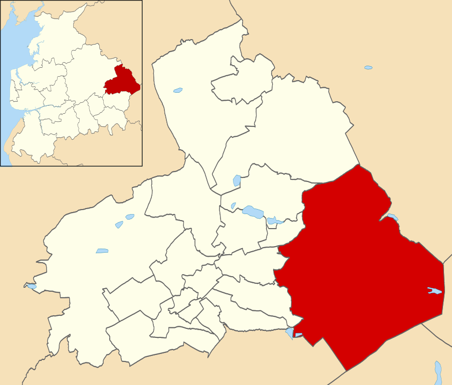
| Description | Map of Pendle, Lancashire, UK with electoral wards shown. Boulsworth ward highlighted. Equirectangular map projection on WGS 84 datum, with N/S stretched 165% Geographic limits: *West: 2.35W *East: 2.04W *North: 53.96N *South: 53.80N |
| Date | (UTC) |
| Source | |
| Author |
|
I, the copyright holder of this work, hereby publish it under the following license:
This file is licensed under the
Creative Commons
Attribution-Share Alike 3.0 Unported license.
- You are free:
- to share – to copy, distribute and transmit the work
- to remix – to adapt the work
- Under the following conditions:
- attribution – You must give appropriate credit, provide a link to the license, and indicate if changes were made. You may do so in any reasonable manner, but not in any way that suggests the licensor endorses you or your use.
- share alike – If you remix, transform, or build upon the material, you must distribute your contributions under the same or compatible license as the original.
Original upload log
This image is a derivative work of the following images:
-
File:Pendle_UK_ward_map_2010_(blank).svg licensed with Cc-by-sa-3.0
- 2011-04-24T22:47:35Z Nilfanion 1425x1214 (320670 Bytes) {{Information |Description=Map of Pendle, Lancashire, UK with electoral wards shown. Equirectangular map projection on WGS 84 datum, with N/S stretched 165% Geographic limits: *West: 2.35W *East: 2.04W *North: 53.96N *South
Uploaded with derivativeFX
File history
Click on a date/time to view the file as it appeared at that time.
| Date/Time | Thumbnail | Dimensions | User | Comment | |
|---|---|---|---|---|---|
| current | 15:44, 7 May 2011 |
| 1,425 × 1,214 (313 KB) | BigDom | {{Information |Description=Map of Pendle, Lancashire, UK with electoral wards shown. Boulsworth ward highlighted. Equirectangular map projection on WGS 84 datum, with N/S stretched 165% Geographic limits: *West: 2.35W *East: 2.04W *North: 53.96N *South: |
File usage
The following pages on the English Wikipedia use this file (pages on other projects are not listed):
Global file usage
The following other wikis use this file:
- Usage on www.wikidata.org