Bostmtnterrain.jpg (800 × 406 pixels, file size: 307 KB, MIME type: image/jpeg)
| Description |
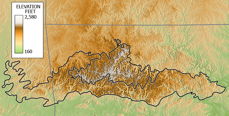
Elevation map of the Boston Mountains of Arkansas and Oklahoma based on Shuttle Radar Topography Mission (SRTM) 3 arcsecond digital elevation model data. |
|---|---|
| Source |
Own work |
| Date |
10 January 2007 |
| Author | |
| Permission ( Reusing this file) |
See below.
|
Elevation map of the Boston Mountains of Arkansas and Oklahoma based on Shuttle Radar Topography Mission (SRTM) 3 arcsecond digital elevation model data.
| I, the copyright holder of this work, hereby release it into the
public domain. This applies worldwide. If this is not legally possible: |
 | This file is a candidate to be copied to
Wikimedia Commons.
Any user may perform this transfer; refer to Wikipedia:Moving files to Commons for details. If this file has problems with attribution, copyright, or is otherwise ineligible for Commons, then remove this tag and DO NOT transfer it; repeat violators may be blocked from editing. Other Instructions
| ||
| |||
| This media file is either in the public domain or published under a free license, and contains no inbound file links. If this media file is useful, then it should be transferred to the Wikimedia Commons. If this media is not useful, then please propose it for deletion or list it at files for discussion. |
File history
Click on a date/time to view the file as it appeared at that time.
| Date/Time | Thumbnail | Dimensions | User | Comment | |
|---|---|---|---|---|---|
| current | 04:46, 12 January 2007 |
| 800 × 406 (307 KB) | Tosborn ( talk | contribs) | Elevation map of the Boston Mountains of Arkansas and Oklahoma based on Shuttle Radar Topography Mission (SRTM) 3 arcsecond digitial elevation model data. |
You cannot overwrite this file.
File usage
Metadata
Bostmtnterrain.jpg (800 × 406 pixels, file size: 307 KB, MIME type: image/jpeg)
| Description |
Elevation map of the Boston Mountains of Arkansas and Oklahoma based on Shuttle Radar Topography Mission (SRTM) 3 arcsecond digital elevation model data. |
|---|---|
| Source |
Own work |
| Date |
10 January 2007 |
| Author | |
| Permission ( Reusing this file) |
See below.
|
Elevation map of the Boston Mountains of Arkansas and Oklahoma based on Shuttle Radar Topography Mission (SRTM) 3 arcsecond digital elevation model data.
| I, the copyright holder of this work, hereby release it into the
public domain. This applies worldwide. If this is not legally possible: |
|
| This file is a candidate to be copied to
Wikimedia Commons.
Any user may perform this transfer; refer to Wikipedia:Moving files to Commons for details. If this file has problems with attribution, copyright, or is otherwise ineligible for Commons, then remove this tag and DO NOT transfer it; repeat violators may be blocked from editing. Other Instructions
| ||
| |||
| This media file is either in the public domain or published under a free license, and contains no inbound file links. If this media file is useful, then it should be transferred to the Wikimedia Commons. If this media is not useful, then please propose it for deletion or list it at files for discussion. |
File history
Click on a date/time to view the file as it appeared at that time.
| Date/Time | Thumbnail | Dimensions | User | Comment | |
|---|---|---|---|---|---|
| current | 04:46, 12 January 2007 |
| 800 × 406 (307 KB) | Tosborn ( talk | contribs) | Elevation map of the Boston Mountains of Arkansas and Oklahoma based on Shuttle Radar Topography Mission (SRTM) 3 arcsecond digitial elevation model data. |
You cannot overwrite this file.