
Size of this PNG preview of this SVG file:
800 × 444 pixels. Other resolutions:
320 × 178 pixels |
640 × 356 pixels |
1,024 × 569 pixels |
1,280 × 711 pixels |
2,560 × 1,422 pixels |
828 × 460 pixels.
Original file (SVG file, nominally 828 × 460 pixels, file size: 132 KB)
| This is a file from the
Wikimedia Commons. Information from its
description page there is shown below. Commons is a freely licensed media file repository. You can help. |
Summary
| Description |
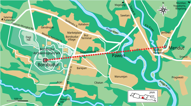
English: The map of Borobudur Archaeological Park and its surrounding, showing that Mendut, Pawon, and Borobudur forming a straight line. Self made, redrawed from google map. |
| Date | |
| Source | Own work |
| Author | Gunawan Kartapranata |
| Other versions |
|


Licensing
I, the copyright holder of this work, hereby publish it under the following licenses:
This file is licensed under the
Creative Commons
Attribution-Share Alike 3.0 Unported license.
- You are free:
- to share – to copy, distribute and transmit the work
- to remix – to adapt the work
- Under the following conditions:
- attribution – You must give appropriate credit, provide a link to the license, and indicate if changes were made. You may do so in any reasonable manner, but not in any way that suggests the licensor endorses you or your use.
- share alike – If you remix, transform, or build upon the material, you must distribute your contributions under the same or compatible license as the original.

|
Permission is granted to copy, distribute and/or modify this document under the terms of the GNU Free Documentation License, Version 1.2 or any later version published by the Free Software Foundation; with no Invariant Sections, no Front-Cover Texts, and no Back-Cover Texts. A copy of the license is included in the section entitled GNU Free Documentation License. |
You may select the license of your choice.
File history
Click on a date/time to view the file as it appeared at that time.
| Date/Time | Thumbnail | Dimensions | User | Comment | |
|---|---|---|---|---|---|
| current | 16:54, 11 March 2011 |
| 828 × 460 (132 KB) | Gunkarta | spelling |
| 16:47, 11 March 2011 |
 | 828 × 460 (132 KB) | Gunkarta | Java, enarging some text | |
| 16:40, 11 March 2011 |
 | 828 × 460 (132 KB) | Gunkarta | {{Information |Description ={{en|1=The map of Borobudur Archaeological Park and its surrounding, showing that Mendut, Pawon, and Borobudur forming a straight line. Self made, redrawed from google map. }} |Source ={{own}} |Author =[[User |
File usage
The following pages on the English Wikipedia use this file (pages on other projects are not listed):
Global file usage
The following other wikis use this file:
- Usage on arz.wikipedia.org
- Usage on ast.wikipedia.org
- Usage on az.wikipedia.org
- Usage on be.wikipedia.org
- Usage on bn.wikipedia.org
- Usage on ca.wikipedia.org
- Usage on cs.wikipedia.org
- Usage on de.wikipedia.org
- Usage on de.wikivoyage.org
- Usage on es.wikipedia.org
- Usage on fr.wikipedia.org
- Usage on gu.wikipedia.org
- Usage on he.wikipedia.org
- Usage on hr.wikipedia.org
- Usage on hy.wikipedia.org
- Usage on ja.wikipedia.org
- Usage on jv.wikipedia.org
- Usage on ml.wikipedia.org
- Usage on mt.wikipedia.org
- Usage on nl.wikipedia.org
- Usage on pt.wikipedia.org
- Usage on ru.wikipedia.org
- Usage on simple.wikipedia.org
- Usage on ta.wikipedia.org
- Usage on www.wikidata.org
Size of this PNG preview of this SVG file:
800 × 444 pixels. Other resolutions:
320 × 178 pixels |
640 × 356 pixels |
1,024 × 569 pixels |
1,280 × 711 pixels |
2,560 × 1,422 pixels |
828 × 460 pixels.
Original file (SVG file, nominally 828 × 460 pixels, file size: 132 KB)
| This is a file from the
Wikimedia Commons. Information from its
description page there is shown below. Commons is a freely licensed media file repository. You can help. |
Summary
| Description |
English: The map of Borobudur Archaeological Park and its surrounding, showing that Mendut, Pawon, and Borobudur forming a straight line. Self made, redrawed from google map. |
| Date | |
| Source | Own work |
| Author | Gunawan Kartapranata |
| Other versions |
|
Licensing
I, the copyright holder of this work, hereby publish it under the following licenses:
This file is licensed under the
Creative Commons
Attribution-Share Alike 3.0 Unported license.
- You are free:
- to share – to copy, distribute and transmit the work
- to remix – to adapt the work
- Under the following conditions:
- attribution – You must give appropriate credit, provide a link to the license, and indicate if changes were made. You may do so in any reasonable manner, but not in any way that suggests the licensor endorses you or your use.
- share alike – If you remix, transform, or build upon the material, you must distribute your contributions under the same or compatible license as the original.
|
|
Permission is granted to copy, distribute and/or modify this document under the terms of the GNU Free Documentation License, Version 1.2 or any later version published by the Free Software Foundation; with no Invariant Sections, no Front-Cover Texts, and no Back-Cover Texts. A copy of the license is included in the section entitled GNU Free Documentation License. |
You may select the license of your choice.
File history
Click on a date/time to view the file as it appeared at that time.
| Date/Time | Thumbnail | Dimensions | User | Comment | |
|---|---|---|---|---|---|
| current | 16:54, 11 March 2011 |
| 828 × 460 (132 KB) | Gunkarta | spelling |
| 16:47, 11 March 2011 |
| 828 × 460 (132 KB) | Gunkarta | Java, enarging some text | |
| 16:40, 11 March 2011 |
| 828 × 460 (132 KB) | Gunkarta | {{Information |Description ={{en|1=The map of Borobudur Archaeological Park and its surrounding, showing that Mendut, Pawon, and Borobudur forming a straight line. Self made, redrawed from google map. }} |Source ={{own}} |Author =[[User |
File usage
The following pages on the English Wikipedia use this file (pages on other projects are not listed):
Global file usage
The following other wikis use this file:
- Usage on arz.wikipedia.org
- Usage on ast.wikipedia.org
- Usage on az.wikipedia.org
- Usage on be.wikipedia.org
- Usage on bn.wikipedia.org
- Usage on ca.wikipedia.org
- Usage on cs.wikipedia.org
- Usage on de.wikipedia.org
- Usage on de.wikivoyage.org
- Usage on es.wikipedia.org
- Usage on fr.wikipedia.org
- Usage on gu.wikipedia.org
- Usage on he.wikipedia.org
- Usage on hr.wikipedia.org
- Usage on hy.wikipedia.org
- Usage on ja.wikipedia.org
- Usage on jv.wikipedia.org
- Usage on ml.wikipedia.org
- Usage on mt.wikipedia.org
- Usage on nl.wikipedia.org
- Usage on pt.wikipedia.org
- Usage on ru.wikipedia.org
- Usage on simple.wikipedia.org
- Usage on ta.wikipedia.org
- Usage on www.wikidata.org