
Original file (2,192 × 1,512 pixels, file size: 2.79 MB, MIME type: image/jpeg)
| This is a file from the
Wikimedia Commons. Information from its
description page there is shown below. Commons is a freely licensed media file repository. You can help. |
Summary
| Description |
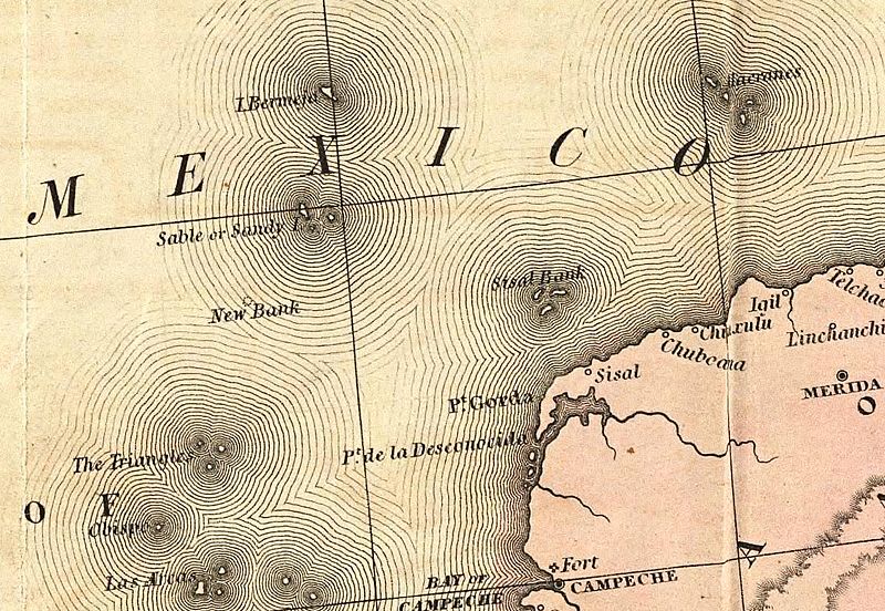
English: Old map showing the Mexican phantom island Bermeja. |
| Date | |
| Source | A Map of the United States of Mexico, 3rd ed. |
| Author | Tanner, Henry S. |
Licensing
|
This work is in the public domain in its country of origin and other countries and areas where the copyright term is the author's life plus 70 years or fewer.
| |
| This file has been identified as being free of known restrictions under copyright law, including all related and neighboring rights. | |
File history
Click on a date/time to view the file as it appeared at that time.
| Date/Time | Thumbnail | Dimensions | User | Comment | |
|---|---|---|---|---|---|
| current | 10:14, 29 July 2016 |
| 2,192 × 1,512 (2.79 MB) | Themadchopper | larger |
| 01:24, 13 March 2009 |
 | 548 × 378 (97 KB) | Gabagool | {{Information |Description={{en|1=Old map showing the Mexican phantom island Bermeja.}} |Source=[http://www.davidrumsey.com/luna/servlet/detail/RUMSEY~8~1~218~20035:A-Map-Of-The-United-States-Of-Mexico] |Author=Tanner, Henry S. |Date=1846 |Permission= |ot |
File usage
Global file usage
The following other wikis use this file:
- Usage on ca.wikipedia.org
- Usage on ceb.wikipedia.org
- Usage on de.wikipedia.org
- Usage on eo.wikipedia.org
- Usage on es.wikipedia.org
- Usage on fr.wikipedia.org
- Usage on he.wikipedia.org
- Usage on hu.wikipedia.org
- Usage on id.wikipedia.org
- Usage on it.wikipedia.org
- Usage on ja.wikipedia.org
- Usage on ko.wikipedia.org
- Usage on pl.wikipedia.org
- Usage on ru.wikipedia.org
- Usage on sv.wikipedia.org
- Usage on uk.wikipedia.org
- Usage on www.wikidata.org
Metadata
Original file (2,192 × 1,512 pixels, file size: 2.79 MB, MIME type: image/jpeg)
| This is a file from the
Wikimedia Commons. Information from its
description page there is shown below. Commons is a freely licensed media file repository. You can help. |
Summary
| Description |
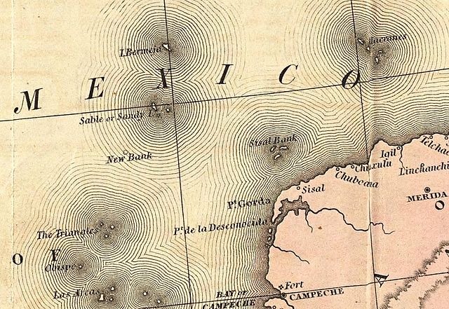
English: Old map showing the Mexican phantom island Bermeja. |
| Date | |
| Source | A Map of the United States of Mexico, 3rd ed. |
| Author | Tanner, Henry S. |
Licensing
|
This work is in the public domain in its country of origin and other countries and areas where the copyright term is the author's life plus 70 years or fewer.
| |
| This file has been identified as being free of known restrictions under copyright law, including all related and neighboring rights. | |
File history
Click on a date/time to view the file as it appeared at that time.
| Date/Time | Thumbnail | Dimensions | User | Comment | |
|---|---|---|---|---|---|
| current | 10:14, 29 July 2016 |
| 2,192 × 1,512 (2.79 MB) | Themadchopper | larger |
| 01:24, 13 March 2009 |
| 548 × 378 (97 KB) | Gabagool | {{Information |Description={{en|1=Old map showing the Mexican phantom island Bermeja.}} |Source=[http://www.davidrumsey.com/luna/servlet/detail/RUMSEY~8~1~218~20035:A-Map-Of-The-United-States-Of-Mexico] |Author=Tanner, Henry S. |Date=1846 |Permission= |ot |
File usage
Global file usage
The following other wikis use this file:
- Usage on ca.wikipedia.org
- Usage on ceb.wikipedia.org
- Usage on de.wikipedia.org
- Usage on eo.wikipedia.org
- Usage on es.wikipedia.org
- Usage on fr.wikipedia.org
- Usage on he.wikipedia.org
- Usage on hu.wikipedia.org
- Usage on id.wikipedia.org
- Usage on it.wikipedia.org
- Usage on ja.wikipedia.org
- Usage on ko.wikipedia.org
- Usage on pl.wikipedia.org
- Usage on ru.wikipedia.org
- Usage on sv.wikipedia.org
- Usage on uk.wikipedia.org
- Usage on www.wikidata.org