This is a file from the Wikimedia Commons
From Wikipedia, the free encyclopedia

Original file(SVG file, nominally 430 × 500 pixels, file size: 20 KB)

Summary

Description
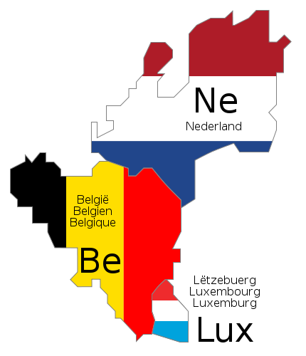
Deutsch: Schematische Karte der Benelux-Länder. Die Länderbezeichnungen sind jeweils in den offiziellen Landessprachen angegeben.
English: Schematic map of Benelux. The country names are given in the official languages of each state.
Français : Carte schématique du Benelux. Les noms des pays sont indiqués dans les langues officielles respectives de chaque état.
Nederlands: Schematische kaart van de Benelux. De landsnamen worden weergegeven in de officiële taal of talen van het betreffende land.
Date
Source Own work. The schematic design is derived from Benelux.png (released under GFDL), and the flag colors were taken from Flag of Belgium.svg, Flag of Luxembourg.svg and Flag of the Netherlands.svg (both PD)
Author
Permission
( Reusing this file)
GNU head Permission is granted to copy, distribute and/or modify this document under the terms of the GNU Free Documentation License, Version 1.2 or any later version published by the Free Software Foundation; with no Invariant Sections, no Front-Cover Texts, and no Back-Cover Texts. A copy of the license is included in the section entitled GNU Free Documentation License.
w:en:Creative Commons
attribution share alike
This file is licensed under the Creative Commons Attribution-Share Alike 3.0 Unported license.
You are free:
  • to share – to copy, distribute and transmit the work
  • to remix – to adapt the work
Under the following conditions:
  • attribution – You must give appropriate credit, provide a link to the license, and indicate if changes were made. You may do so in any reasonable manner, but not in any way that suggests the licensor endorses you or your use.
  • share alike – If you remix, transform, or build upon the material, you must distribute your contributions under the same or compatible license as the original.
This licensing tag was added to this file as part of the GFDL licensing update.
Other versions
SVG development
InfoField
 
The SVG code is valid.
 
This flag map was created with Inkscape.
 
 This flag map uses embedded text that can be easily translated using a text editor.

Information

Captions

Add a one-line explanation of what this file represents

In dieser Datei abgebildete Objekte

depicts

17 June 2009

image/svg+xml

a624c2fe9295977c1b2942034b9d1647276ed2ee

20,393 byte

500 pixel

430 pixel

File history

Click on a date/time to view the file as it appeared at that time.

Date/TimeThumbnailDimensionsUserComment
current 10:46, 17 June 2009 Thumbnail for version as of 10:46, 17 June 2009430 × 500 (20 KB) Bibi Saint-Polfix internal trouble with text nodes
10:28, 17 June 2009 Thumbnail for version as of 10:28, 17 June 2009430 × 500 (21 KB) Bibi Saint-Pol{{inkscape}} {{Information |Description= {{en|1=Schematic map of w:en:Benelux. The country names are given in the official languages of each state.}} {{fr|1=Carte schématique du w:fr:Benelux. Les noms des pays sont indiqués dans les langues of
The following pages on the English Wikipedia use this file (pages on other projects are not listed):

Global file usage


Videos

Youtube | Vimeo | Bing

Websites

Google | Yahoo | Bing

Encyclopedia

Google | Yahoo | Bing

Facebook