
Original file (1,000 × 632 pixels, file size: 113 KB, MIME type: image/png)
| This is a file from the
Wikimedia Commons. Information from its
description page there is shown below. Commons is a freely licensed media file repository. You can help. |
Summary
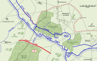
Map of Bazentin le Petit sector on the morning of 14 July 1916, Battle of Bazentin Ridge, showing the German second defensive position.
German trenches are shown in blue, including the communications trenches connecting to the (captured) first position. German barbed wire is shown as dotted blue lines. The start line of the assault brigades of the British 21st Division is shown in red. The position reached by the 21st Division and neighbouring 7th Division at 9 am is shown as the dashed red line.
Based on a trench map from the British Public Record Office.
| This work has been released into the
public domain by its author,
Gsl. This applies worldwide. In some countries this may not be legally possible; if so: |
File history
Click on a date/time to view the file as it appeared at that time.
| Date/Time | Thumbnail | Dimensions | User | Comment | |
|---|---|---|---|---|---|
| current | 10:38, 21 October 2005 |
| 1,000 × 632 (113 KB) | Igiveup | Map of Bazentin le Petit sector on the morning of 14 July 1916, Battle of Bazentin Ridge, showing the German second defensive position. German trenches are shown in blue, including the communications trenches connecting to the (captured) first position. |
File usage
Global file usage
The following other wikis use this file:
- Usage on af.wikipedia.org
- Usage on azb.wikipedia.org
- Usage on ca.wikipedia.org
- Usage on el.wikipedia.org
- Usage on es.wikipedia.org
- Usage on fr.wikipedia.org
- Usage on hu.wikipedia.org
- Usage on id.wikipedia.org
- Usage on it.wikipedia.org
- Usage on lt.wikipedia.org
- Usage on no.wikipedia.org
Original file (1,000 × 632 pixels, file size: 113 KB, MIME type: image/png)
| This is a file from the
Wikimedia Commons. Information from its
description page there is shown below. Commons is a freely licensed media file repository. You can help. |
Summary
Map of Bazentin le Petit sector on the morning of 14 July 1916, Battle of Bazentin Ridge, showing the German second defensive position.
German trenches are shown in blue, including the communications trenches connecting to the (captured) first position. German barbed wire is shown as dotted blue lines. The start line of the assault brigades of the British 21st Division is shown in red. The position reached by the 21st Division and neighbouring 7th Division at 9 am is shown as the dashed red line.
Based on a trench map from the British Public Record Office.
| This work has been released into the
public domain by its author,
Gsl. This applies worldwide. In some countries this may not be legally possible; if so: |
File history
Click on a date/time to view the file as it appeared at that time.
| Date/Time | Thumbnail | Dimensions | User | Comment | |
|---|---|---|---|---|---|
| current | 10:38, 21 October 2005 |
| 1,000 × 632 (113 KB) | Igiveup | Map of Bazentin le Petit sector on the morning of 14 July 1916, Battle of Bazentin Ridge, showing the German second defensive position. German trenches are shown in blue, including the communications trenches connecting to the (captured) first position. |
File usage
Global file usage
The following other wikis use this file:
- Usage on af.wikipedia.org
- Usage on azb.wikipedia.org
- Usage on ca.wikipedia.org
- Usage on el.wikipedia.org
- Usage on es.wikipedia.org
- Usage on fr.wikipedia.org
- Usage on hu.wikipedia.org
- Usage on id.wikipedia.org
- Usage on it.wikipedia.org
- Usage on lt.wikipedia.org
- Usage on no.wikipedia.org