
Size of this PNG preview of this SVG file:
465 × 465 pixels. Other resolutions:
240 × 240 pixels |
480 × 480 pixels |
768 × 768 pixels |
1,024 × 1,024 pixels |
2,048 × 2,048 pixels.
Original file (SVG file, nominally 465 × 465 pixels, file size: 173 KB)
| This is a file from the
Wikimedia Commons. Information from its
description page there is shown below. Commons is a freely licensed media file repository. You can help. |
Summary
| Description |
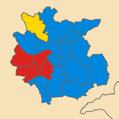
English: Map of Bath, Avon, UK showing the results of the 1983 local election.
Colours: Conservative
Labour
SDP-Liberal Alliance |
| Date | |
| Source |
This file was derived from:
Bath UK ward map 1975 (blank).svg:
|
| Author |
|
.svg)
Licensing
This file is licensed under the
Creative Commons
Attribution-Share Alike 4.0 International license.
- You are free:
- to share – to copy, distribute and transmit the work
- to remix – to adapt the work
- Under the following conditions:
- attribution – You must give appropriate credit, provide a link to the license, and indicate if changes were made. You may do so in any reasonable manner, but not in any way that suggests the licensor endorses you or your use.
- share alike – If you remix, transform, or build upon the material, you must distribute your contributions under the same or compatible license as the original.
File history
Click on a date/time to view the file as it appeared at that time.
| Date/Time | Thumbnail | Dimensions | User | Comment | |
|---|---|---|---|---|---|
| current | 07:56, 4 May 2020 |
| 465 × 465 (173 KB) | Ytfc23 | Correcting the Bathwick/Combe Down ward boundary. |
| 17:11, 3 May 2020 |
 | 465 × 465 (172 KB) | Ytfc23 | Uploaded a work by * Bath UK ward map 1975 (blank).svg: Ytfc23, created using Ordnance Survey data *Derivative work: Ytfc23 from {{Derived from|Bath UK ward map 1975 (blank).svg|display=50}} with UploadWizard |
.svg)
File usage
The following pages on the English Wikipedia use this file (pages on other projects are not listed):
Metadata
Size of this PNG preview of this SVG file:
465 × 465 pixels. Other resolutions:
240 × 240 pixels |
480 × 480 pixels |
768 × 768 pixels |
1,024 × 1,024 pixels |
2,048 × 2,048 pixels.
Original file (SVG file, nominally 465 × 465 pixels, file size: 173 KB)
| This is a file from the
Wikimedia Commons. Information from its
description page there is shown below. Commons is a freely licensed media file repository. You can help. |
Summary
| Description |
English: Map of Bath, Avon, UK showing the results of the 1983 local election.
Colours: Conservative
Labour
SDP-Liberal Alliance |
| Date | |
| Source |
This file was derived from:
Bath UK ward map 1975 (blank).svg:
|
| Author |
|
Licensing
This file is licensed under the
Creative Commons
Attribution-Share Alike 4.0 International license.
- You are free:
- to share – to copy, distribute and transmit the work
- to remix – to adapt the work
- Under the following conditions:
- attribution – You must give appropriate credit, provide a link to the license, and indicate if changes were made. You may do so in any reasonable manner, but not in any way that suggests the licensor endorses you or your use.
- share alike – If you remix, transform, or build upon the material, you must distribute your contributions under the same or compatible license as the original.
File history
Click on a date/time to view the file as it appeared at that time.
| Date/Time | Thumbnail | Dimensions | User | Comment | |
|---|---|---|---|---|---|
| current | 07:56, 4 May 2020 |
| 465 × 465 (173 KB) | Ytfc23 | Correcting the Bathwick/Combe Down ward boundary. |
| 17:11, 3 May 2020 |
| 465 × 465 (172 KB) | Ytfc23 | Uploaded a work by * Bath UK ward map 1975 (blank).svg: Ytfc23, created using Ordnance Survey data *Derivative work: Ytfc23 from {{Derived from|Bath UK ward map 1975 (blank).svg|display=50}} with UploadWizard |
File usage
The following pages on the English Wikipedia use this file (pages on other projects are not listed):