
Size of this preview:
800 × 589 pixels. Other resolutions:
320 × 235 pixels |
640 × 471 pixels |
1,024 × 753 pixels |
1,280 × 942 pixels |
2,560 × 1,884 pixels |
4,000 × 2,943 pixels.
Original file (4,000 × 2,943 pixels, file size: 6.85 MB, MIME type: image/png)
| This is a file from the
Wikimedia Commons. Information from its
description page there is shown below. Commons is a freely licensed media file repository. You can help. |
| Description |
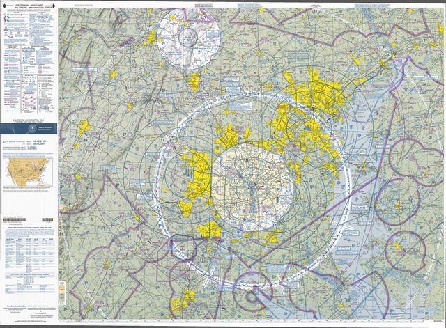
English: VFR Terminal Area Raster Aeronautical Chart Baltimore/Washington, 82nd edition. This map is valid until 28 July 2011, be sure to get the newest edition at the official
FAA website |
| Date |
|
| Source | Baltimore-Washington_TAC_82.tif in Baltimore-Washington_TAC_82.zip. Note: The ZIP-File may become unavailable when the map is updated, newer editions will be available here |
| Author | US Department of Transportation, Federal Aviation Administration, National Aeronautical Navigation Services |
| Other versions |
This image or file is a work of a
Federal Aviation Administration employee, taken or made as part of that person's official duties. As a
work of the
U.S. federal government, the image is in the
public domain in the United States.
|
 |
File history
Click on a date/time to view the file as it appeared at that time.
| Date/Time | Thumbnail | Dimensions | User | Comment | |
|---|---|---|---|---|---|
| current | 12:54, 27 April 2011 |
| 4,000 × 2,943 (6.85 MB) | El Grafo | smaller version to enable thumbnails |
| 12:49, 27 April 2011 |
 | 8,000 × 5,885 (25.57 MB) | El Grafo | {{Information |Description={{en|1=VFR Terminal Area Raster Aeronautical Chart Baltimore/Washington, 82nd edition. This map is valid until {{date|2011|07|28}}, be sure to get the newest edition at the official [http://aeronav.faa.gov/index.asp?xml=aeronav/ |
File usage
The following pages on the English Wikipedia use this file (pages on other projects are not listed):
Global file usage
The following other wikis use this file:
- Usage on bg.wikipedia.org
- Usage on de.wikipedia.org
- Usage on fa.wikipedia.org
- Usage on fi.wikipedia.org
- Usage on ja.wikipedia.org
- Usage on oc.wikipedia.org
- Usage on vi.wikipedia.org
Size of this preview:
800 × 589 pixels. Other resolutions:
320 × 235 pixels |
640 × 471 pixels |
1,024 × 753 pixels |
1,280 × 942 pixels |
2,560 × 1,884 pixels |
4,000 × 2,943 pixels.
Original file (4,000 × 2,943 pixels, file size: 6.85 MB, MIME type: image/png)
| This is a file from the
Wikimedia Commons. Information from its
description page there is shown below. Commons is a freely licensed media file repository. You can help. |
| Description |
English: VFR Terminal Area Raster Aeronautical Chart Baltimore/Washington, 82nd edition. This map is valid until 28 July 2011, be sure to get the newest edition at the official
FAA website |
| Date |
|
| Source | Baltimore-Washington_TAC_82.tif in Baltimore-Washington_TAC_82.zip. Note: The ZIP-File may become unavailable when the map is updated, newer editions will be available here |
| Author | US Department of Transportation, Federal Aviation Administration, National Aeronautical Navigation Services |
| Other versions |
This image or file is a work of a
Federal Aviation Administration employee, taken or made as part of that person's official duties. As a
work of the
U.S. federal government, the image is in the
public domain in the United States.
|
|
File history
Click on a date/time to view the file as it appeared at that time.
| Date/Time | Thumbnail | Dimensions | User | Comment | |
|---|---|---|---|---|---|
| current | 12:54, 27 April 2011 |
| 4,000 × 2,943 (6.85 MB) | El Grafo | smaller version to enable thumbnails |
| 12:49, 27 April 2011 |
| 8,000 × 5,885 (25.57 MB) | El Grafo | {{Information |Description={{en|1=VFR Terminal Area Raster Aeronautical Chart Baltimore/Washington, 82nd edition. This map is valid until {{date|2011|07|28}}, be sure to get the newest edition at the official [http://aeronav.faa.gov/index.asp?xml=aeronav/ |
File usage
The following pages on the English Wikipedia use this file (pages on other projects are not listed):
Global file usage
The following other wikis use this file:
- Usage on bg.wikipedia.org
- Usage on de.wikipedia.org
- Usage on fa.wikipedia.org
- Usage on fi.wikipedia.org
- Usage on ja.wikipedia.org
- Usage on oc.wikipedia.org
- Usage on vi.wikipedia.org